Atchison County flood map guides property owners on hazard zones
Atchison County’s flood-zone map ties owners to the FEMA records that drive insurance, permits, and lending. The key zones, tools, and local communities are all in one place.
A property near the Missouri River in Atchison can look dry on a clear day and still sit inside a mapped flood zone. Atchison County keeps its flood-zones page, county web map, and FEMA materials together for owners, buyers, builders, lenders, and renters in Atchison, Effingham, Huron, Lancaster, Muscotah, and the unincorporated parts of the county.
It is tied to official map records, floodplain rules, and the county’s own land-use process, including Resolution #2014-1393 and the development-permit materials that cite K.S.A. 12-766 and K.A.R. 5-44-1 through 5-44-6.
Start with the county map
Start with the Atchison County flood-zones page, which points straight to the county’s web map and FEMA-related floodplain documents. The county’s preliminary Flood Insurance Study for Atchison County and incorporated areas covers the City of Atchison, Atchison County unincorporated areas, the City of Effingham, the City of Huron, the City of Lancaster, and the City of Muscotah.
Use that county map first, then compare what you see with FEMA’s Flood Map Service Center, the official federal source for flood map searches and map products. If a parcel sits near the Missouri River, in low ground, or in one of the county’s incorporated communities, the map check should happen before you sign a contract, pull a permit, or assume flood insurance will not matter.
A straightforward way to work through it:
1. Open the county flood-zones page and search the parcel or address on the county web map.
2. Check whether the site falls inside a Special Flood Hazard Area.
3. Compare the parcel against FEMA map products and, if needed, the Kansas floodplain viewer.
4. Pull any map-change records, such as a Letter of Map Amendment or a Letter of Map Revision-Based on Fill, before you rely on the current label.
What the FEMA records actually decide
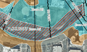
FEMA defines a Special Flood Hazard Area as the area subject to flooding by the 1% annual chance flood. The listed special flood hazard zones are A, AE, AH, AO, AR, and A99.
A floodplain is the broader area that can flood, while a floodway is the part of the floodplain that carries moving water and is usually treated more tightly in development decisions. A property can be close to water and still not be mapped in the highest-risk zone, which is why proximity alone is not enough for an insurance or lending decision.
FEMA mapping exists for Atchison County and its incorporated communities. If you are comparing old assumptions with current records, the official label comes from the map set and the related studies, not from a neighbor’s memory of where water stood in a previous storm.
Why the zone affects insurance, permits, and financing
Flood-zone status can change the cost and paperwork attached to a property. Homes or lots mapped in a Special Flood Hazard Area often trigger stronger lender scrutiny, and flood insurance questions become central instead of optional. Even where a lender does not require coverage, the map status can still influence what an insurer quotes and how a buyer prices the risk.
Permits can be affected just as quickly. Atchison County’s floodplain-management resolution says the county intends to recognize and evaluate flood hazards in official land-use actions, and the county’s permit materials tie that work to the floodplain-management ordinance and Kansas regulations. The result is that a deck, addition, fill project, driveway change, or new build can require a floodplain review before the county signs off.
Resale is affected too. Buyers, appraisers, title companies, and lenders often want the same questions answered before closing: is the lot in a special flood hazard area, is there a floodway on or near the parcel, and has FEMA ever changed the mapped status. If the answer is unclear, the file can slow down even when the house itself has never flooded.
Where Atchison County residents should look closely
The county’s strongest local reference points are the City of Atchison, the Missouri River corridor, and the incorporated communities named in the county’s flood study: Effingham, Huron, Lancaster, and Muscotah.
Kansas also keeps a current effective floodplain viewer and a Base Flood Elevation Portal. The elevation portal is a collaboration between the Kansas Geological Survey’s Data Access and Support Center and the Kansas Department of Agriculture’s Division of Water Resources, which makes it useful when a property owner needs more than a simple yes-or-no zone answer.
Before assuming a parcel is safe, ask these specific questions:
- Is my parcel in a Special Flood Hazard Area, and if so, which zone is it in?
- Is there a mapped floodway nearby that could affect what I can build?
- What is the base flood elevation for the site?
- Has FEMA issued a Letter of Map Amendment or a Letter of Map Revision-Based on Fill for this parcel?
- Do the county map and the FEMA map still match?
Why the maps keep changing
FEMA does not treat flood mapping as a one-time decision. It provides tools for Letters of Map Amendment and Letters of Map Revision-Based on Fill, along with a public status page for map change requests. Those tools exist because survey data, fill, and engineering studies can change how a parcel is mapped over time.
This article was produced by Prism’s automated news system from verified source data, official records, and press releases, then run through automated quality and moderation checks before publishing. The system is built and supervised by the people who set the standards it runs under. Read our full AI policy.
Did this article answer your question?