Baker County braces for rare May heat, record highs possible Sunday, Tuesday
Baker City could hit 86 today and 91 Tuesday, threatening May records as the warm spell raises fire risk and strain on ranch work, irrigation and outdoor plans.
Five days of unusual May warmth will push Baker County into a summer-like pattern just as ranch crews, gardeners, outdoor workers and spring sports are getting busy. Baker City could touch 86 degrees today and climb to 91 Tuesday, a level that would put new pressure on local records and dry out fuels across Eastern Oregon.
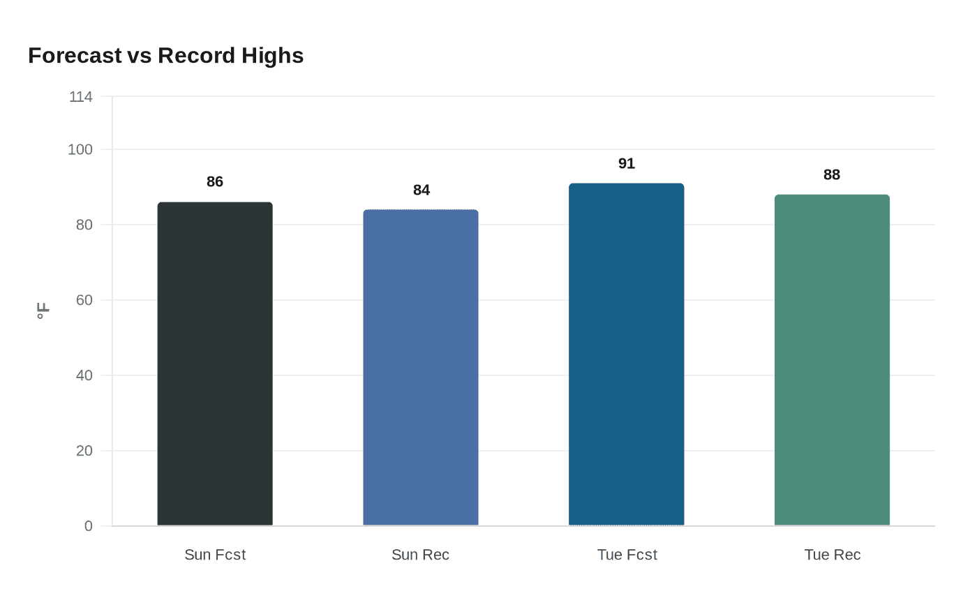
The National Weather Service office in Pendleton, which serves northeast Oregon and uses weather risk outlooks and briefing products for local forecasting, says a high-pressure ridge will keep sunshine abundant for much of the week. Sunday’s forecast high of 86 would edge past the May 10 record of 84 degrees set in 2013. Tuesday’s forecast of 91 would break the May 12 mark of 88 set in 1993. Baker City Airport has only reached 90 degrees this early in the season in one other year on record, 1966, when temperatures hit 90 on May 3 and May 4.

The practical impact will be felt far beyond the thermometer. Early-season heat can speed evaporation from fields and gardens, increase irrigation demand and force ranchers to check stock water sooner. Outdoor workers and anyone spending long hours on pavement, construction sites or county roads will need to plan for heat that is far more typical of midsummer than mid-May. Seniors, students and athletes with afternoon activities will also face warmer conditions than many have seen so far this spring.
The warmth also adds to fire concern in a region that is already dry enough to warrant close attention. The Baker Field Office of the Bureau of Land Management is based in Baker City and manages about a half million acres across eight counties in Oregon and Washington. The agency says about 87 percent of wildfires nationwide are caused by people, and its Oregon and Washington fire restriction order applies to all BLM-managed public lands from May through October. During periods of high or extreme danger, restrictions can limit campfires, chainsaws, smoking and access to some locations.
Baker City has already run warmer than usual in the first week of May, with daytime highs in the 70s, and NOAA climate normals are designed as the baseline for judging how far this stretch runs above typical conditions. A cooldown beginning Wednesday should ease the record threat, with highs settling back into the low 80s and no new record concerns later in the week. Until then, Baker County is facing a short, sharp burst of heat that could change how people work, travel and burn in the open country.
This article was produced by Prism’s automated news system from verified source data, official records, and press releases, then run through automated quality and moderation checks before publishing. The system is built and supervised by the people who set the standards it runs under. Read our full AI policy.
Did this article answer your question?