Baker County Faces High Wind Watch Saturday, Gusts Expected Through Evening
A cold front is pushing west-to-northwest winds through Baker County today, with gusts potentially reaching 41 mph in Baker City and up to 50 mph on ridgetops.

A cold front swept into Baker County on Saturday, bringing the strong west-to-northwest winds the National Weather Service had been forecasting since Thursday, with gusts expected to continue through the evening hours.
The National Weather Service office in Boise issued a high wind watch for Baker County covering 11 a.m. to 8 p.m. Saturday, citing west winds of 30 to 40 mph with gusts up to 55 mph possible, particularly on ridgetops. By early Saturday morning, the agency issued an updated wind advisory for Baker, Harney, and Malheur counties, with the revised forecast calling for northwest winds of 25 to 35 mph and gusts up to 50 mph. Baker City itself is forecast to see gusts as high as 41 mph, with the mountains bearing the brunt of the strongest winds.
The NWS Boise advisory, updated at 2:40 a.m. Saturday, warned that "gusty winds will blow around unsecured objects," that tree limbs could come down, and that power outages were possible. High-profile vehicles face particular hazards on the road. "Winds this strong can make driving difficult, especially for high profile vehicles," the advisory stated. "Use extra caution."
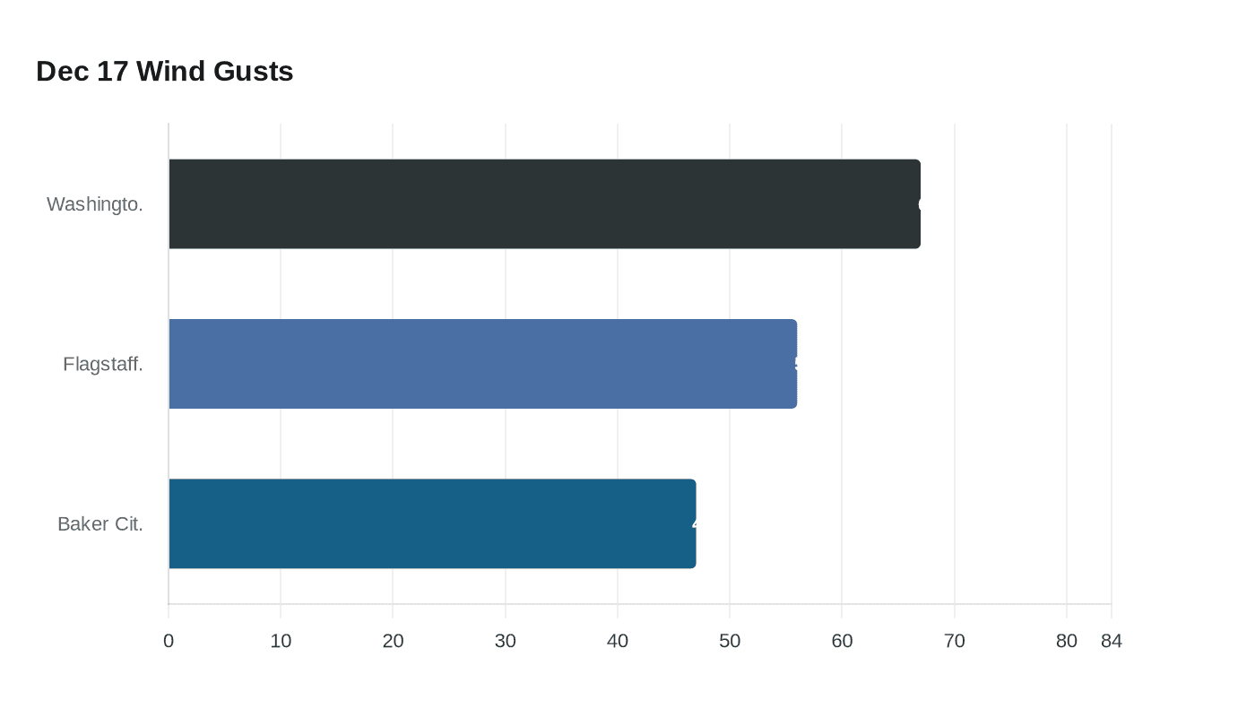
The storm draws a direct comparison to a December 17, 2025 event that left a measurable mark across Baker Valley. That day, the Baker City Airport recorded a peak gust of 47 mph, while a weather station operated by Oregon Trail Electric Cooperative at Washington Gulch and Pocahontas roads, about three miles west of Baker City, clocked a 67 mph gust at 7:15 a.m. A wind gauge at the Oregon Trail Interpretive Center on Flagstaff Hill, roughly five miles east of the city, hit 56 mph.
The December storm knocked out power to 1,081 Oregon Trail Electric Cooperative customers in Baker County, with the hardest-hit area centered on Haines, where 764 customers lost service. About 277 customers in the Wingville area were also without power. The cooperative restored service to all customers by that evening. The Baker County Sheriff's Office dispatch center fielded multiple reports of downed power lines across Baker Valley, including on Pocahontas, Brown, and Old Wingville roads.
The distinction between the current watch and a higher-level warning matters for how residents should respond. A watch signals that conditions are favorable for high winds to develop; if damaging winds appear nearly certain, the weather service can upgrade it to a warning. Saturday's early-morning advisory update indicated the agency was tracking the storm closely as it moved through the region.
Securing outdoor objects and monitoring NWS updates through the afternoon and evening remains the primary guidance from forecasters as the front pushes through.
This article was produced by Prism’s automated news system from verified source data, official records, and press releases, then run through automated quality and moderation checks before publishing. The system is built and supervised by the people who set the standards it runs under. Read our full AI policy.
Did this article answer your question?