Baker County guide highlights Hells Canyon Scenic Byway stops, routes
The byway's real value in Baker County is practical: Baker City, Richland and Halfway are the stops that keep visitors spending, while remote miles demand fuel and lodging planning.
Baker City sits at the intersection of three Oregon Scenic Byways, Richland and Halfway anchor the middle of the route, and Hewitt Holcomb Park gives visitors a county-run base along Brownlee Reservoir. The road also demands planning: there are more than eighty miles without gas, and its backroads can shift with snow, road debris and seasonal openings.
Baker County towns that benefit most
Baker City is the natural place to start or finish a Hells Canyon run because the byway intersects Interstate 84 there, and travelers should reserve lodging before the trip. From there, the money trail spreads into smaller stops that matter to local businesses: Travel Baker County highlights Richland, Hewitt Holcomb Park, Halfway and the bottom of Hells Canyon as favorite stops, and its boating guide ties Hewitt Holcomb Park to Brownlee Reservoir, campgrounds and boat ramps.
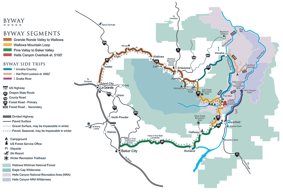
How the route lays out
Travel Oregon lists the Hells Canyon Scenic Byway as a 208-mile, 335-kilometer loop through northeastern Oregon, with the best driving window from June through October. The route circles the Wallowa Mountains and connects with Interstate 84 at both La Grande and Baker City, so Baker County is one gateway among several, not the only one. The route crosses land tied to the ancestral homeland of the Nez Perce tribe, and the U.S. Forest Service says Hells Canyon National Recreation Area covers 652,488 acres and includes the deepest river gorge in North America.
Mileage that matters on the ground
Halfway to Copperfield at the Snake River is 21 paved miles, Copperfield to Hells Canyon Dam is 27 paved miles, and Copperfield back to Baker City is 70 paved miles on OR 86. Joseph to Hells Canyon Overlook is a gravel side trip for a canyon view from above, and the entire byway is paved highway even though the overlook spur is not. Before they leave town, travelers are steered toward a free Oregon State Highway map, the Hells Canyon Scenic Byway brochure and the Hells Canyon and Wallowa Mountains Outdoor Recreation map.
Conditions that change plans
The byway is remote enough that road conditions can change a day on the road without much warning. As of June 3, 2026, Forest Road 39 between Halfway and the Pine Valley, Joseph and Enterprise was open to passenger vehicles, with livestock, wildlife, narrow stretches, potholes, rocks and sticks still a hazard, especially early in the season. The Joseph-to-Halfway segment closes with snow in winter, and most of the drive passes through natural regions with limited services. Travelers who want current trail, campground or backroad information are directed to the ranger district offices at Halfway or Joseph.
River access, campgrounds and spending
For travelers who want to get off the pavement, Brownlee Reservoir and the Snake River create the most obvious places to spend time and money. Brownlee Reservoir forms the eastern border of Baker County, a boating and fishing destination with multiple campgrounds and boat ramps, including Hewitt Holcomb Park in Richland and other recreation sites along Snake River Road between Richland and Huntington. Below Hells Canyon Dam, the wild and scenic section of the Snake River opens into rafting and jet-boat country, with Canyon Outfitters and Hells Canyon Adventures as local guides. The U.S. Forest Service requires a permit to float the Wild and Scenic Snake River at any time of year, with the primary season running from the Friday before Memorial Day through September 10 under the Four Rivers Lottery.
Why the byway matters to county policy
Travel Oregon says scenic byway travelers spend an average of $104 per day, and federal byway designation can make communities eligible for special grant funding opportunities. The Oregon Department of Transportation’s management plan records that the route’s significance was established through inventory work and public outreach, and it records an early debate over whether increased tourism was desirable before concluding that Baker County’s focus is tourism as a chief economic strategy.
This article was produced by Prism’s automated news system from verified source data, official records, and press releases, then run through automated quality and moderation checks before publishing. The system is built and supervised by the people who set the standards it runs under. Read our full AI policy.
Did this article answer your question?