Baker County Trails Offer Alpine Lakes, Ridgelines and Mining History Nearby
Alpine lakes, ridgelines and old mining scars sit within an hour of Baker City — here's how to find the best of them this spring and summer.

The Elkhorn and Blue mountain ranges bracket Baker County like a pair of outstretched arms, and what lies within their reach surprises even longtime residents. Within a short drive of Baker City, trails climb to glittering alpine lakes, trace exposed ridgelines with views stretching across high desert and timbered slopes, and wind through landscapes still marked by the picks and sluice boxes of Oregon's mining era. Spring and summer open the full menu, and knowing where to start makes the difference between a memorable day out and a frustrating search for a trailhead.
Where the mountains begin
Baker County's geography is the reason this trail network exists at all. The Blue Mountains rise to the northwest and the Elkhorns push up sharply to the west and southwest of Baker City, forming a compact mountain island above the surrounding rangeland. Elevations climb quickly once you leave the valley floor, which means that within roughly an hour of downtown Baker City you can move from high desert scrub into subalpine forest and, higher still, into open rocky terrain above treeline. That vertical range is what delivers the variety: a single day can include wildflower meadows at mid-elevation, a cold lake basin tucked beneath a granite ridgeline, and a return through terrain that still shows the earthwork scars of nineteenth-century mining operations.
Alpine lakes worth the climb
Few destinations in eastern Oregon punch above their weight the way the alpine lake basins of the Elkhorns do. These lakes sit in glacially carved bowls, typically accessible by trail once snowpack recedes in late spring or early summer. Water temperatures stay cold well into August, which keeps crowds modest even on peak weekends. The trails to these basins tend to gain elevation steadily rather than brutally, making them accessible to hikers with moderate fitness while still rewarding the effort with genuine alpine scenery: rocky shorelines, reflected peaks, and the kind of quiet that is genuinely hard to find closer to town.
Timing matters here. Snowmelt can linger at higher elevations into June some years, and trails that look passable on a map may still cross wet or icy stretches in early spring. Checking current conditions before heading out is worth the extra step, particularly for basins above 7,000 feet.
Ridgeline routes and long views
The Elkhorn Crest is the signature high-country experience for Baker County hikers. The ridgeline runs north to south along the spine of the Elkhorn Mountains and offers the kind of panoramic exposure that makes a moderate hike feel considerably more dramatic. On clear days the views extend across the Baker Valley to the Wallowa Mountains to the northeast, and westward into the layered ridges of the broader Blue Mountain system. Trails along or approaching the crest tend to be well-defined and can be tackled as out-and-back day hikes or linked together for longer routes.
Wind and afternoon thunderstorms are the practical considerations on any exposed ridgeline. Summer storms can build quickly over the Elkhorns, and the open terrain that makes the views so good also offers no shelter. Starting early and being willing to turn around if weather develops is the sensible approach rather than a precautionary one.
Mining history written on the land
Baker County was shaped as much by gold and silver as by geology, and that history is still visible on the ground in ways that make these trails more than just a workout. The region saw significant mining activity in the latter half of the 1800s, and remnants of that era, collapsed adits, tailing piles, disturbed drainages, and the occasional standing structure, appear along several trail corridors. These are not museum exhibits behind glass; they are simply part of the landscape, which is part of what makes them interesting.
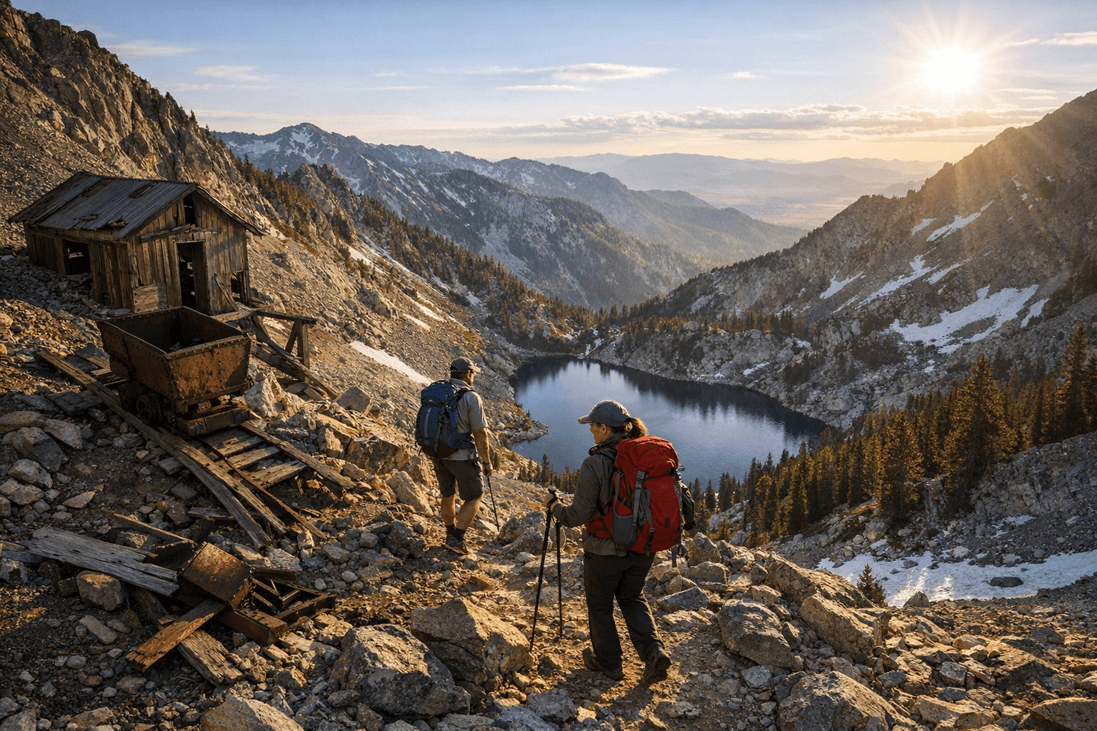
The presence of old mine workings also comes with a practical note: open shafts and unstable structures deserve a wide berth. The visual interest is real, but the physical risks of approaching deteriorating mine infrastructure are equally real. The best approach is to observe these features from the trail and resist the temptation to explore further.
For anyone interested in the deeper history, Baker City itself holds significant context. The town's architecture and the resources at the Oregon Trail Interpretive Center connect the mining and settlement eras to the landscape you are walking through, and a visit to either before or after a trail day adds a layer of meaning to what you have seen.
Planning a spring or summer day
The window for comfortable, snow-free hiking across most of Baker County's higher trails runs from late June through September, with July and August being the most reliably open months. Lower elevation trails and those on south-facing slopes can be accessible earlier, sometimes by late April or May. The shoulder seasons, particularly late spring and early fall, offer cooler temperatures and noticeably fewer people, which is often the best combination available.
A few practical considerations apply across most of these routes:
- Bring more water than you expect to need. Springs and streams exist but water sources at higher elevations are not always reliable late in the season.
- Cell coverage is limited to nonexistent on most Elkhorn and Blue Mountain trails. Download offline maps before leaving Baker City.
- Afternoon thunderstorms are a regular feature of the July and August pattern. Plan to be off exposed ridgelines by early afternoon.
- Early June hikers should carry microspikes or be prepared to turn back if lingering snow makes a trail unsafe.
- A current Recreate Responsibly approach to fire restrictions matters: summer fire danger in the Elkhorns can be extreme, and open fires may be prohibited on many days.
Getting oriented from Baker City
Baker City sits at roughly 3,450 feet elevation, which means the trailheads you are heading toward often start well above that. Most Elkhorn Crest access points are reachable via paved and improved gravel roads, though road conditions vary by season and recent weather. A high-clearance vehicle is not required for most popular trailheads but is useful for the more remote access roads.
The compact geography that makes Baker County so appealing for day hiking is also its defining character. You do not need to drive five hours to reach genuine mountain terrain. The alpine lakes, the long ridgeline views, and the mining-era remnants are all within reach of a morning departure from Baker City, which leaves the afternoon free for the kind of quiet recovery that a good day in the mountains earns.
This article was produced by Prism’s automated news system from verified source data, official records, and press releases, then run through automated quality and moderation checks before publishing. The system is built and supervised by the people who set the standards it runs under. Read our full AI policy.
Did this article answer your question?