Petroglyph National Monument offers trail hikes and ancient rock art
Just minutes from metro Albuquerque, Petroglyph National Monument lets you hike among volcanic cliffs and centuries-old carvings without leaving the city.
A rare kind of access-to-history outing
Petroglyph National Monument stands out on Albuquerque’s west side because it puts deep cultural history within easy reach of Bernalillo County residents. In one place, you get short hikes, wide desert views, volcanic rock, and thousands of ancient carvings etched into basalt by people who lived here long before the modern city took shape.
The monument protects one of the largest petroglyph sites in North America, and its appeal is as practical as it is historic. You can spend an hour or a half day there without leaving the metro area, which makes it one of the most accessible ways to experience the region’s archaeology, geology, and Indigenous history in the same outing.
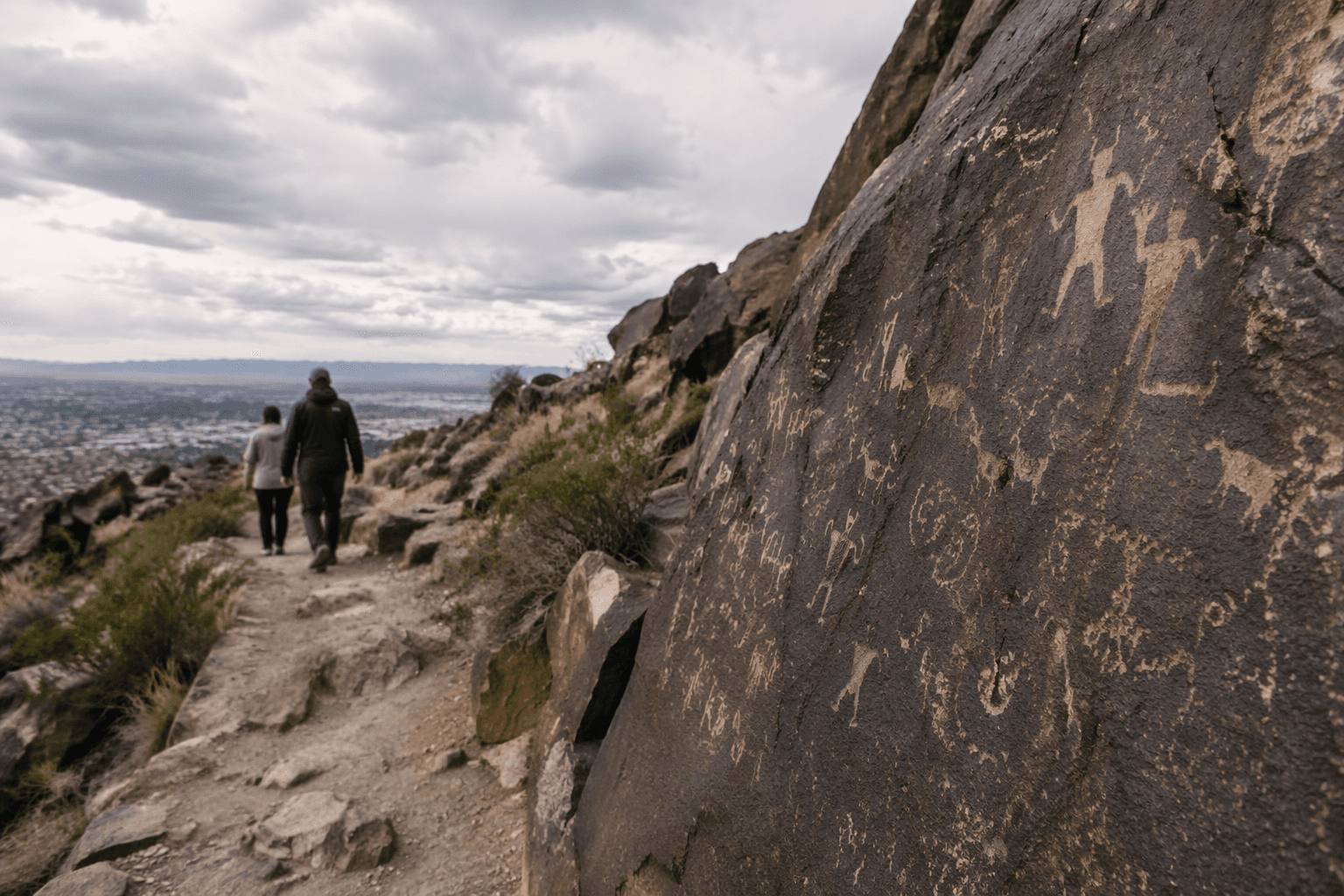
What the landscape is telling you
The monument stretches about 17 miles along Albuquerque’s West Mesa, with a western boundary that includes a chain of dormant fissure volcanoes. Those dark basalt cliffs are not just dramatic scenery. They are part of a landscape shaped by eruptions more than 100,000 years ago, and they became a canvas for rock art over many centuries.
National Park Service materials say the carvings and symbols on the volcanic rocks were made by Native Americans and Spanish settlers 400 to 700 years ago. Partner materials also note that some images may be as old as 3,000 years, and that about 90 percent of the petroglyphs were made by ancestral Puebloans. That long span is what makes the monument feel less like a single historic site and more like a record of generations of human presence.
The broader timeline matters, too. Ancestral Puebloan carving traditions developed across the centuries before and after Spanish colonization began in 1540, followed by the Pueblo Revolt in 1680 and Spanish recolonization in 1692. Those shifts shaped who lived in the region, who moved through it, and who left marks on the stone.
Which trail areas best show the monument’s story
The trail system is part of the monument’s appeal because it offers different ways to encounter the same landscape. Some trailheads are best for quick petroglyph viewing, while others emphasize the geology and open desert views that frame the volcanic escarpment. That variety makes the site useful whether you are bringing kids, walking with visitors, or looking for a quieter hike close to home.
Several named access areas help define the experience:
Boca Negra Canyon
This area is a strong choice when you want a more immediate connection to the rock art. It is one of the places where the monument’s carvings and basalt cliffs come together most directly, making it a good introduction for first-time visitors who want a clear view of why the site is protected.
Rinconada Canyon
Rinconada gives you a broader sense of the monument’s desert setting. It is well suited to visitors who want to understand the scale of the West Mesa and the relationship between the open landscape and the carved volcanic rocks.
Volcanoes Day Use Area
If the geology is what you want to see first, this area is the place to start. It connects the monument’s volcanic history to the trails and helps explain why the basalt escarpment became such an important place for rock art.
Piedras Marcadas Canyons
This section adds another layer to the story by showing how petroglyphs appear across different parts of the monument, not just in a single canyon. It reinforces the idea that the site is a network of cultural resources spread across the mesa, not a one-stop viewpoint.
How to visit without damaging what makes the site special
Petroglyph National Monument is not only a recreation area, it is also a protected cultural landscape. Park materials describe it as culturally significant to many contemporary Indigenous peoples, which means the carvings are not just old images to photograph. They are sacred and archaeological resources that still matter today.
The basic rules of respectful visiting are simple, but they matter a great deal:
- Stay on marked trails.
- Do not touch, chalk, trace, or climb on petroglyphs.
- Treat carved rocks as heritage, not props.
- Pack out trash and leave the landscape as you found it.
- Plan your timing carefully, because the monument is a day-use park.
That last point is important for anyone planning a stop after work or before dinner. The visitor center and trailhead parking lots close in the afternoon, with access managed to protect the site and keep use concentrated during daytime hours. The day-use format is one reason the monument still feels relatively intact despite how close it is to a major city.
Why the monument matters now
Petroglyph National Monument was authorized on June 27, 1990, which makes it a young federal protection for an ancient landscape. The monument is cooperatively managed by the National Park Service and the City of Albuquerque, a partnership that reflects its dual role as both a protected cultural resource and a local public destination.
For Bernalillo County, that mix is part of the point. You can stand on Albuquerque’s west side and see volcanic landforms, ancestral imagery, and living cultural significance in the same frame. Few places in the metro area offer that combination of easy access and long human memory, and fewer still ask so clearly for careful, respectful visitation.
Petroglyph National Monument endures because it is not only scenery. It is one of the clearest places in the county where the present-day city meets a much older story, still visible in stone.
This article was produced by Prism’s automated news system from verified source data, official records, and press releases, then run through automated quality and moderation checks before publishing. The system is built and supervised by the people who set the standards it runs under. Read our full AI policy.
Know something we missed? Have a correction or additional information?
Submit a Tip