Hawaii Mesonet Records 135 mph Wind Gust During Powerful Kona Low Storm
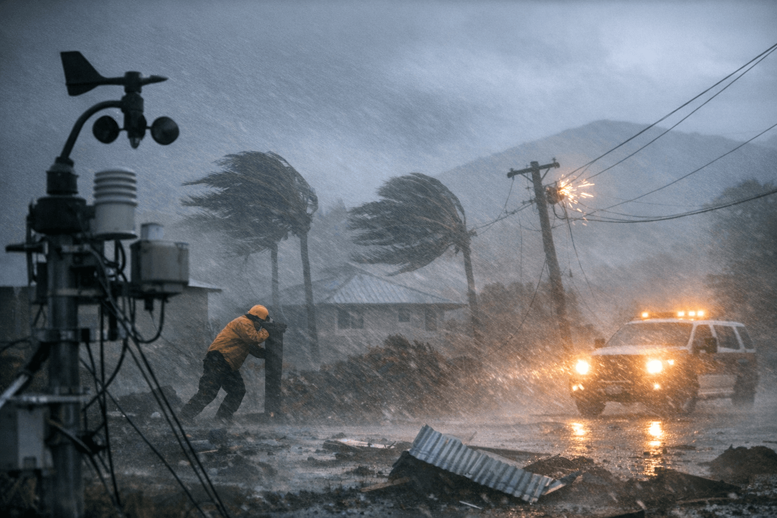
A North Kona weather station recorded a 135.4 mph gust at 4:20 a.m. on March 14, with sustained winds averaging 105 mph — the force of a Category 2 hurricane.

At 4:20 a.m. on March 14, the Kaiāulu Puʻuwaʻawaʻa Hawaiʻi Mesonet station in North Kona captured a maximum wind gust of 135.4 mph, according to the UH Hawaiʻi Climate Data Portal, as a powerful Kona low system pushed hurricane-force conditions across the Big Island.
The reading was not an isolated spike. Between 4:10 and 4:25 a.m., sustained winds at the station averaged 105 mph over that 15-minute period, a threshold the University of Hawaiʻi described as equivalent to a Category 2 hurricane. The UH Hawaiʻi Climate Data Portal's storm report noted that the Kaiāulu Puʻuwaʻawaʻa station "recorded wind speeds that frequently exceeded 100 mph between midnight and 6:45 AM" on March 14. A High Wind Warning was in effect for the entire Big Island at the time.
Rainfall compounded the destruction. The University reported that Hawaiʻi Island recorded 16 to 32 inches of rain across broad areas, with isolated spots nearing 62 inches, and flash flooding was reported across the island. On Maui, peak totals reached up to 62 inches in local areas. The Kuiki Hawaiʻi Mesonet station on the east rim of Haleakalā crater recorded 36 inches in a 24-hour period beginning Friday evening, March 13. At the upper elevations of Haleakalā, 33 inches fell in the 24-hour period beginning Friday morning, March 13, nearly doubling the previous record for 24-hour rainfall there, according to KHON2's reporting of UH Climate Data Portal figures.
The storm's extremes were documented by the Hawaiʻi Mesonet, a University of Hawaiʻi weather monitoring network that now operates more than 70 stations statewide. Tom Giambelluca, the Mesonet's project lead and former director of the UH Water Resources Research Center, said the network fills a gap that left much of the state blind to localized weather threats.
"Before the project began, Hawaiʻi was one of only 20 states without a comprehensive statewide weather monitoring system, meaning we previously had no access to information in many of these areas," Giambelluca said in a University news release. "Now, the system is constantly collecting data on rainfall, soil moisture, and other weather variables that can tell us in real time if an area is highly susceptible to fires or flooding, which ultimately allows us to be as prepared as possible."
The Kaiāulu Puʻuwaʻawaʻa station sits with Maunakea visible in the background, a remote North Kona location that, without the Mesonet, would have produced no instrument record of one of the most intense wind events to strike Hawaiʻi Island in recent years.
This article was produced by Prism’s automated news system from verified source data, official records, and press releases, then run through automated quality and moderation checks before publishing. The system is built and supervised by the people who set the standards it runs under. Read our full AI policy.
Did this article answer your question?