Lapakahi trail reveals how ancient North Kohala villagers survived the coast
Lapakahi’s 1.1-mile loop shows how North Kohala villagers used salt pans, canoe plants and a protected reef to survive a dry coast.

A dry mile of lava and shoreline in North Kohala opens a window into survival. At Lapakahi State Historical Park, the trail is a self-guided walk through partially restored village remains on an easy 1.1-mile loop with about 50 feet of elevation gain. The park opens daily from 8 a.m. to 3:30 p.m., the gate locks at 4 p.m., and there is no entrance fee, making it one of the simplest ways to read Hawaii Island’s coastal history on foot.
What the trail reveals
Lapakahi is set up as two linked loops, and that structure matters. The main 0.5-mile loop leads to a canoe hālau, salt-making pans, and the major walled habitation complex along Koaie Cove, while a second 0.3-mile loop continues north so visitors can see more of how the village worked. The route is short, but it is packed with the physical signs of a community that had to organize daily life around a dry shoreline, limited freshwater, and the resources it could gather from both land and sea.
That is why the park is useful for more than a quick stop between Waimea, Kawaihae, and Hāwī. The trail is easy, the ground is dry and open, and the path gives a clear look at how a coastal settlement was arranged to support fishing, salt making, and household life in one place. Lapakahi is not a scenic ruin on the edge of the ocean; it is a mapped-out lesson in how North Kohala people adapted to a harsh environment and made a village function there.
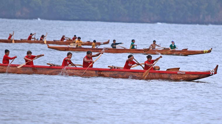
Salt, canoes and a working coastal economy
The village layout shows how interdependent the coast was. Salt-making pans sat near the canoe hālau and the habitation area because these were not separate activities. They were part of a single system in which people processed food, prepared for fishing, and moved goods along the shoreline and beyond.
The park brochure also points to canoe plants such as māo, milo, hinahina kahakai, ilima, and niu. Those plants supported food, medicine, building materials, cordage, dye, and shade, which is exactly the kind of practical knowledge that kept a small coastal community viable. On a dry coast where every resource had to be used carefully, the landscape itself was part of the village infrastructure.

Lapakahi sits within an ahupuaa system that linked mauka and makai, and that is the key to understanding the place today. The trail once connected land and sea exchange, so the salt pans, canoe structures, habitation complex, and nearshore reef should be read together rather than as isolated attractions. The site shows how survival depended on moving through, and managing, the entire coastal ecosystem.
How the park became protected ground
Lapakahi State Historical Park was officially established in 1973, and it was added to the National Register of Historic Places on July 2, 1973. That timeline matters because it shows the village was recognized early as a place worth preserving, not simply a scenic stretch of coast. It also means the park has been under formal state stewardship for decades, long enough for its meaning to expand from archaeology into public education and coastal management.
A major shoreline parcel was added in March 2011, when 17 acres were brought into the park. The tract had been threatened with potential development, and the inholding contained hundreds of pre-contact sites, including a fishing village, canoe landing areas, and residences of konohiki or alii. That addition was a policy decision as much as a preservation move, because it protected land that still carried the layout of the ancient shoreline community.
The 2011 acquisition also tied Lapakahi to wider North Kohala conservation efforts involving local organizations, NOAA, the State Legacy Land Conservation Program, and other partners. The result is a park boundary that reflects active stewardship, not just old maps. What visitors see today is shaped by public action taken to keep the coast open, readable, and intact.
The reef offshore is part of the story
The marine landscape off Lapakahi matters just as much as the ruins on land. The Lapakahi Marine Life Conservation District covers 146 acres, was established in 1979, and its boundary extends about 500 feet from shore. Subzone A includes Koaie Cove, the same area that anchors the interpretive trail and the village’s visible remains.

That protection makes the site useful in present-day debates over reef stewardship and climate resilience. The brochure warns that strong currents exist beyond Koaie Cove and urges visitors to stay within the protected area, a reminder that the ocean here is not a backdrop. It is a living part of the cultural landscape, and the rules that govern it shape both safety and conservation.
Archaeology, erosion and living stewardship
Lapakahi has been a major archaeological case study for decades. William Bonk’s 1969 excavations in the southern portions of Koaie Village produced key material for understanding the site, and earlier excavation work framed the village through an ecological approach that linked settlement patterns to native land divisions and surrounding resources. That scholarship is one reason Lapakahi is so often used to explain how Hawaiian communities organized life in difficult coastal settings.
The site is also changing in real time. A 2023 report documented storm damage that exposed a coastal midden in the interpretive area, at a canoe shed site first recorded in the 1970s. Radiocarbon dating from that work suggests the deposits began accumulating in the late prehistoric period, which turns erosion into a preservation issue with direct consequences for what survives on the shoreline.
Lapakahi is not only a historic place; it is also a place where Hawaiian knowledge continues. Friends of the Future says haumāna of Papa Henry Auwae steward a portion of the park under an agreement with the Department of Land and Natural Resources and continue practicing lāau lapaau there. That living use gives the park an added layer of meaning: it is a place where cultural practice, teaching, and caretaking still sit alongside archaeology and public access.
For anyone walking the loop, the lesson is plain. Lapakahi shows how North Kohala villagers survived by tying salt, fishing, settlement design, native plants, and reef stewardship into one working system, and that system still shapes how the coast should be understood today.
This article was produced by Prism’s automated news system from verified source data, official records, and press releases, then run through automated quality and moderation checks before publishing. The system is built and supervised by the people who set the standards it runs under. Read our full AI policy.
Did this article answer your question?