Wind Advisory Continues for Big Island Summits, Gusts Reaching 60 mph
Summit winds of 35–50 mph with 60 mph gusts persist on the Big Island after a high wind warning was canceled, the tail end of a powerful Kona low.
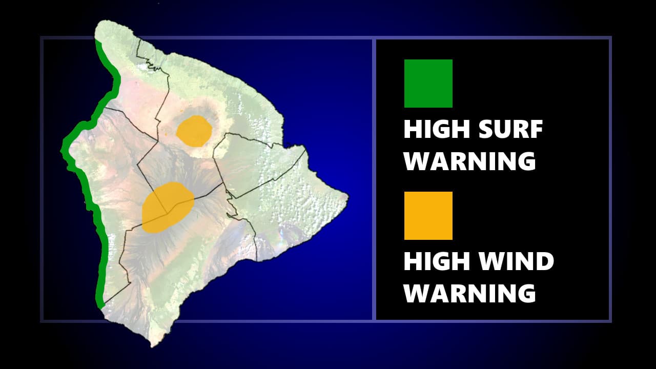
Sustained winds of 35 to 50 mph with gusts reaching 60 mph continued to batter Big Island summits through Wednesday, with the National Weather Service maintaining a wind advisory even after canceling the more severe high wind warning that had been in effect during the peak of a powerful Kona low weather system.
The advisory is the remnant of a storm that brought blizzard conditions to the highest elevations starting Thursday evening, March 12, with forecasters describing high levels of instability, wind shear, and atmospheric forcing converging over the islands. By Friday, March 13, conditions had intensified enough that southwesterly winds were driving damaging gusts along mountain slopes, with the northern and eastern slopes of steep terrain bearing the worst of it. The NWS said Hawaiʻi should expect "a combination of flash flooding, damaging winds, snow and ice over the highest Big Island summits, and strong to severe thunderstorms over the next few days."
The Kona low generated hazards far beyond wind. A Winter Storm Warning for Big Island summits placed conditions at elevations above roughly 11,000 feet into the extremely hazardous category, with snow and ice compounding the sustained gusts. Statewide, the storm prompted closures of public and charter schools, state offices, and Judiciary operations on Friday, March 13. On Oʻahu, a flash flood warning for the entire island was extended until at least 2:45 p.m. that Thursday, and flooding shuttered Haleʻiwa Elementary and Waialua High and Intermediate schools on the North Shore.
Thunderstorms capable of producing hurricane-force gusts over coastal waters represented an additional threat through Saturday, with Big Island Video News reporting that even outside of terrain-enhanced gusts, strong convective cells could produce severe wind events along the shoreline and over open water.

Kilauea added another layer of hazard during the event. According to the U.S. Geological Survey, an eruptive episode sent tephra outside Hawaii Volcanoes National Park into adjacent communities, compounding conditions already strained by wind, flooding, and winter weather at elevation.
The current advisory, with its 60 mph ceiling on gusts, represents a significant step down from the storm's peak, when wind gust reports exceeded 100 mph and caused widespread power outages across the state. Anyone traveling to or working near Mauna Kea or Mauna Loa summit areas should confirm current NWS Honolulu products before heading up, as advisory boundaries and effective periods can shift quickly in the aftermath of a Kona low of this magnitude.
This article was produced by Prism’s automated news system from verified source data, official records, and press releases, then run through automated quality and moderation checks before publishing. The system is built and supervised by the people who set the standards it runs under. Read our full AI policy.
Did this article answer your question?