Buncombe County formed in 1791, built on centuries of Indigenous history
Buncombe County’s lines and Asheville’s courthouse power trace back to 1791, but the deeper story begins with Cherokee homelands and thousands of years of Indigenous life.
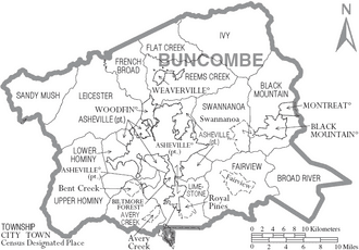
Buncombe County’s map still carries two histories at once: a county formed by a 1791 legislative act and a much older landscape shaped for thousands of years by Indigenous peoples. Asheville’s rise as the county seat in 1797 fixed where courts, records, and county business would sit, and that decision still shapes how people in Black Mountain, Weaverville, Woodfin, Candler, Arden, Fairview and Leicester experience local government.
Before the county, this was Indigenous land
Archaeologists and county historians place human presence in the area far earlier than the county’s creation. The Cherokee are identified as the first Native American residents of present-day Buncombe County, and the county’s own historic material says Indigenous peoples and cultures lived here for thousands of years before European settlement. That longer timeline matters because Buncombe did not begin with a courthouse or a boundary line. It began with a homeland.
The valley-and-ridge landscape that later became Buncombe was part of a wider Indigenous world long before the first permanent county lines were drawn. Any account of the county has to start there, because the later political map was laid over places already known, traveled, and inhabited for generations.
1791: carving a county out of the frontier
Buncombe County was created in 1791 from parts of Burke and Rutherford counties. The North Carolina General Assembly drafted the bill in December 1791, and some county-history accounts say the original proposed name was Union before lawmakers changed it to Buncombe. The county took its name from Colonel Edward Buncombe, a Revolutionary War soldier, giving the new county a post-Revolution identity tied to the politics of the young state.
That founding was not just a naming exercise. It marked the reorganization of a frontier region as settlement pushed westward and new administrative boundaries followed. Buncombe also sat in a larger western district that later gave rise to counties including Haywood, Yancey, Henderson and Madison, so its creation was part of a wider pattern of subdivision as North Carolina’s mountain counties took shape.
The geography of the place explains part of the boundary story. Settlers began crossing into the Swannanoa Valley shortly after the Revolutionary War, around 1784 or 1785, and the Swannanoa River area had served as a dividing line between Burke and Rutherford counties before Buncombe was formed. In other words, the county was not drawn on blank paper. It emerged from a landscape already used to mark movement, settlement and jurisdiction.
Why Asheville became the seat
Asheville was established as the seat of the newly created Buncombe County in 1797, and that choice still defines where power concentrates. Courts, records, public meetings and many county services are centered in Asheville, which means the city became more than a population center. It became the organizing town for Buncombe’s public business.
Asheville was officially incorporated in 1797 and named for Governor Samuel Ashe. One preservation source describes the city’s early role plainly: it prospered as a thoroughfare for settlers moving west and drovers moving livestock. That combination of county government and traffic through town helped turn Asheville into the region’s administrative and commercial hub, not just a place on the map but the place where the map’s decisions were managed.
The courthouse decision matters because it shaped everyday civic life. Residents who need court records, attend county meetings or deal with county agencies still travel to Asheville for much of that business. The county seat fixed the center of gravity early, and it has stayed there.
The county lines still shape local identity
Buncombe’s boundaries are old, but they still organize how people think about where they live and who governs them. A county formed from Burke and Rutherford now contains a mix of mountain communities and Asheville neighborhoods that share one county system while maintaining distinct identities of their own. That tension between one county government and many place-based identities is part of Buncombe’s civic character.
The county’s 2020 population was 269,452, a reminder that a political boundary drawn in the 18th century now governs a large modern population. The same courthouse-centered structure that made sense for a frontier county still channels services and records for a metropolitan county with far more residents, neighborhoods, and local concerns than the founders could have imagined.
That is why the old geography still shows up in present-day life. Asheville’s role as county seat keeps public power concentrated downtown, while communities beyond the city limits remain tied to decisions made there. The county’s origin story is not abstract. It explains why some residents think of Asheville as the place where Buncombe County happens, even when they live miles away in the county’s mountain communities.
Why the early record is incomplete
Buncombe County’s early paper trail is thinner than many people assume. Courthouse fires in 1830 and 1865 destroyed many early records, wiping out a large part of the county’s documentary memory. That loss helps explain why later historians, genealogists and special collections researchers have had to reconstruct pieces of the county’s early story from scattered references and later accounts.
The damaged record is not a footnote. It affects how the county remembers itself. When records disappear, names, petitions, land changes and local disputes become harder to trace, which is one reason Buncombe’s early history often rests on a mix of legislative history, county histories and preservation work rather than a complete archive.
What Buncombe’s founding still explains
Buncombe County was not simply created in 1791. It was assembled from older boundary lines, Indigenous homelands and a frontier settlement pattern that pushed into the Swannanoa Valley after the Revolution. Asheville’s selection as county seat in 1797 locked in a civic center that still concentrates government power, records and routine county business.
That is why Buncombe County still looks the way it does. Its neighborhoods and towns sit inside lines drawn when the county was formed from Burke and Rutherford, and its public life still bends toward Asheville because lawmakers and settlers made it so more than two centuries ago.
This article was produced by Prism’s automated news system from verified source data, official records, and press releases, then run through automated quality and moderation checks before publishing. The system is built and supervised by the people who set the standards it runs under. Read our full AI policy.
Did this article answer your question?