BLM Prescribed Burn Chars 291 Acres Along Dolores River West Rim
U.S. Wildland Firefighters burned 291 acres along the Dolores River West Rim on March 13, with smoke drifting into low-lying areas after dark.

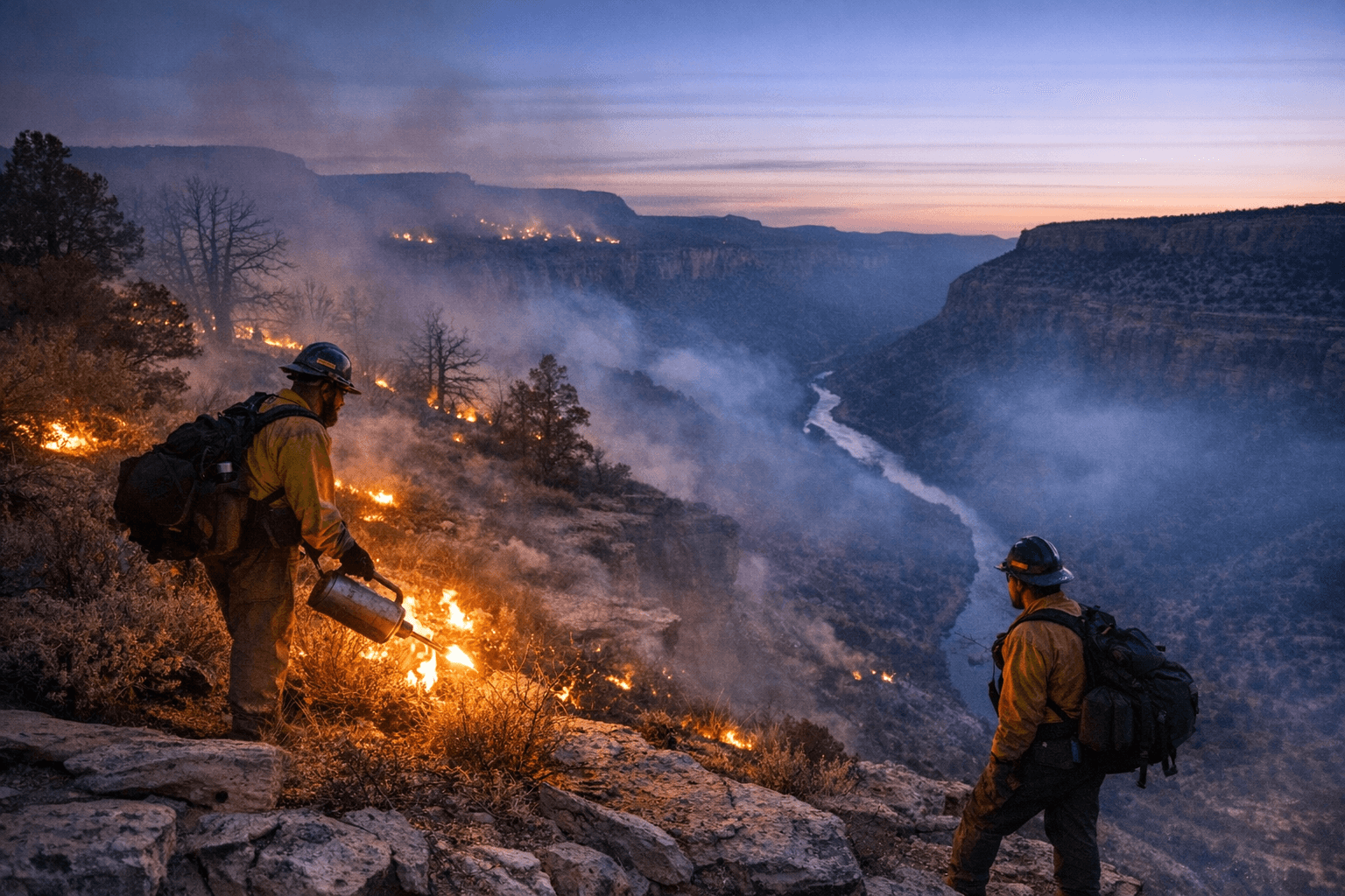
Smoke rose above the West Rim of the Dolores River on March 13 as U.S. Wildland Firefighters completed a prescribed burn covering approximately 291 acres. The burn was visible throughout the day, with smoke potentially settling into low-lying areas after dark, according to updates pushed through official BLM accounts alongside links to air quality information.
The operation fits within a broader vegetation management effort by the BLM Tres Rios Field Office across two project areas east of Dove Creek. In the West Dolores Rim Project Area, located about seven miles east of Dove Creek and known locally as the "East and North Pines," crews are working to treat up to 1,900 acres of ponderosa pine and Gambel oak. Separately, the Dawson Project Area, split between San Miguel and Dolores counties roughly 13 miles east-northeast of Dove Creek and 10 miles east of Egnar, is slated for treatment of up to 885 acres of pinyon, juniper, and mixed mountain shrub.
Tyler Corbin, acting BLM Fire Management Specialist, described the controls built into each operation. "Both project areas have detailed prescribed burn plans outlining specific parameters that must be met to ensure the burn is controlled successfully," Corbin said. "We will continue to monitor weather conditions and air quality to minimize the potential for smoke impacts on the health and safety of our communities and fire resources."
Smoke permits obtained from the Colorado State Air Pollution Control Division govern the atmospheric conditions under which any burn can proceed. BLM planning materials note that smoke during daytime operations is concentrated mostly during the warmest hours, while cooler evening temperatures can allow smoke to linger and accumulate in low-lying terrain, including the Dolores River Canyon.
The San Juan National Forest's Dolores Ranger District is running parallel prescribed burn work in the same region. A separate planning release from the Dolores Ranger District noted that smoke from those operations may be visible as far as Mancos, Cortez, and along Highway 491 between Dove Creek and Pleasant View.
The agencies cite several overlapping goals: reducing the hazardous fuels that feed large unplanned wildfires, protecting wildland-urban interface communities, improving big game and sage grouse habitat, and restoring the fire-adapted ponderosa pine ecosystems that historically shaped this landscape. BLM noted that several West Dolores Rim Project units treated in prior seasons are already showing signs of improved habitat.
A fall burn window is also planned for the West Rim corridor, with a separate 370-acre unit northeast of Dove Creek and 552 acres at Rabbit Mountain, northwest of Bayfield, targeted for September through October treatment depending on weather and fuel conditions.
Residents with questions about prescribed burn timing or smoke impacts can contact Southwest District Fire Mitigation Specialist John Wroblewski at (970) 240-5335, or Dolores Ranger District Acting Fire Management Officer Caleb Schutz at (970) 882-6844 or Caleb.Schutz@usda.gov. Maps and operational updates are posted to InciWeb at inciweb.wildfire.gov, and air quality information is available through the Colorado Air Pollution Control Division's website.
This article was produced by Prism’s automated news system from verified source data, official records, and press releases, then run through automated quality and moderation checks before publishing. The system is built and supervised by the people who set the standards it runs under. Read our full AI policy.
Did this article answer your question?


