McPhee Reservoir Powers Agriculture, Tribal Water, and Life in Dolores County
McPhee Reservoir delivers 90,900 acre-feet of water annually across 61,660 acres, making it the engine behind Dolores County's farms, tribal lands, municipal taps, and a trout fishery below the dam.
90,900 acre-feet of water moving through 48 miles of tunnels and canals to a tribal reservation, under fields of alfalfa and barley in Dove Creek, and through the taps of towns across Montezuma Valley: that is what McPhee Reservoir delivers every average year. Few pieces of infrastructure in southwestern Colorado carry this much weight for this many people, and fewer still carry it so quietly.
What the Dolores Project Actually Does
McPhee Dam and Reservoir is the principal storage feature of the Dolores Project, which includes a system of canals, tunnels, and laterals to deliver water to over 61,000 acres of land. The project, located in the Dolores and San Juan River Basins in southwestern Colorado, provides project water for 61,660 acres and benefits the area's economy by increasing agricultural production and strengthening service-related enterprises dependent on agriculture.
The purposes are deliberately broad: this multipurpose project provides 12.8 MW of installed generating capacity along with municipal and industrial water, irrigation water, and recreation and fish and wildlife enhancement. It serves the Dove Creek area, central Montezuma Valley, and communities on the Ute Mountain Ute Indian Reservation at Towaoc, making it a hub for competing and complementary interests across county and tribal lines.
The Infrastructure Moving Water Across the Region
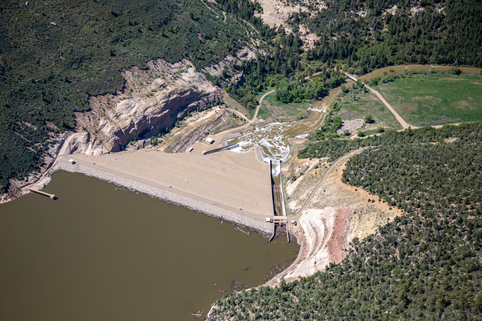
Primary storage of Dolores River flows for all project purposes is provided by McPhee Reservoir, formed by McPhee Dam and Great Cut Dike. From that central point, an intricate delivery network fans out in three directions.
Water for the Dove Creek area travels through one of the most mechanically demanding routes in the system. The Dove Creek Canal heads at the end of the pump discharge line at Great Cut Dike and extends northwest for 39.5 miles to Monument Creek Reservoir. It has an initial capacity of 380 cubic feet per second and a terminal capacity of 30 cubic feet per second. The South Canal, a 7.6-mile branch off the main canal, further extends delivery to surrounding agricultural lands.
Towaoc receives its water through an entirely different corridor. Water for that area is conveyed 48 miles from the reservoir by the Dolores Tunnel and the Dolores and Towaoc Canals. Both the Dove Creek and Towaoc service areas rely on sprinkler irrigation systems, while the Montezuma Valley area is served by releases at Great Cut Dike and the Dolores Tunnel and Canal feeding into an existing gravity distribution system.
McPhee Dam, located on the Dolores River, is a rolled earth, sand, gravel, and rockfill structure with a volume of approximately 6,230,000 cubic yards. The crest of the dam is 270 feet high above streambed, 1,300 feet in length, and 30 feet wide. The reservoir has a total capacity of 381,195 acre-feet, including 229,200 acre-feet of active capacity, 151,900 acre-feet of inactive capacity, and 95 acre-feet of dead storage.
Feeding the Fields: Agriculture and the Local Economy
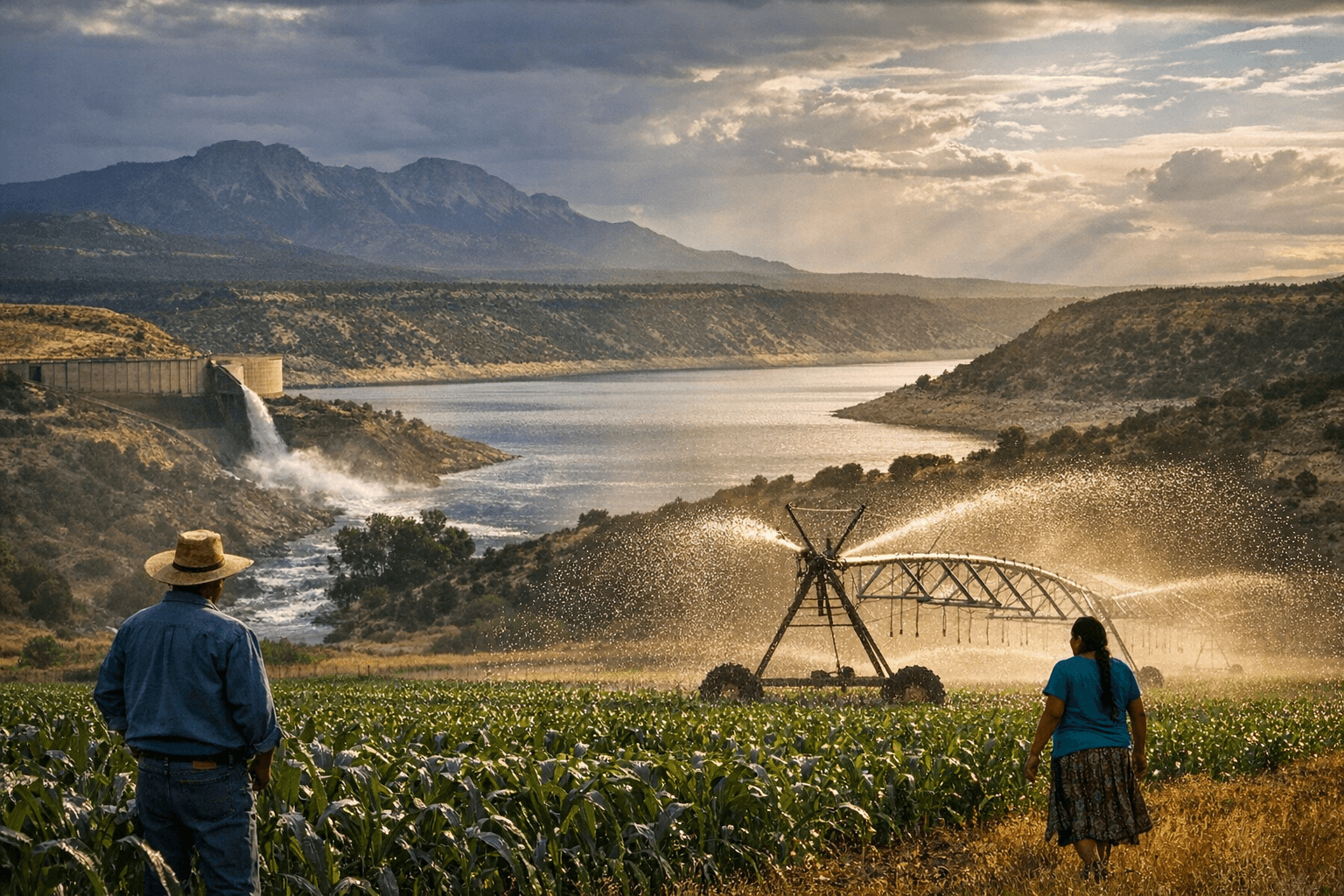
Project water is available for 61,660 acres and benefits the area's economy by increasing agricultural production and strengthening service-related enterprises dependent on agriculture. Main crops are alfalfa, pasture, barley, oats, and corn silage for livestock feed.
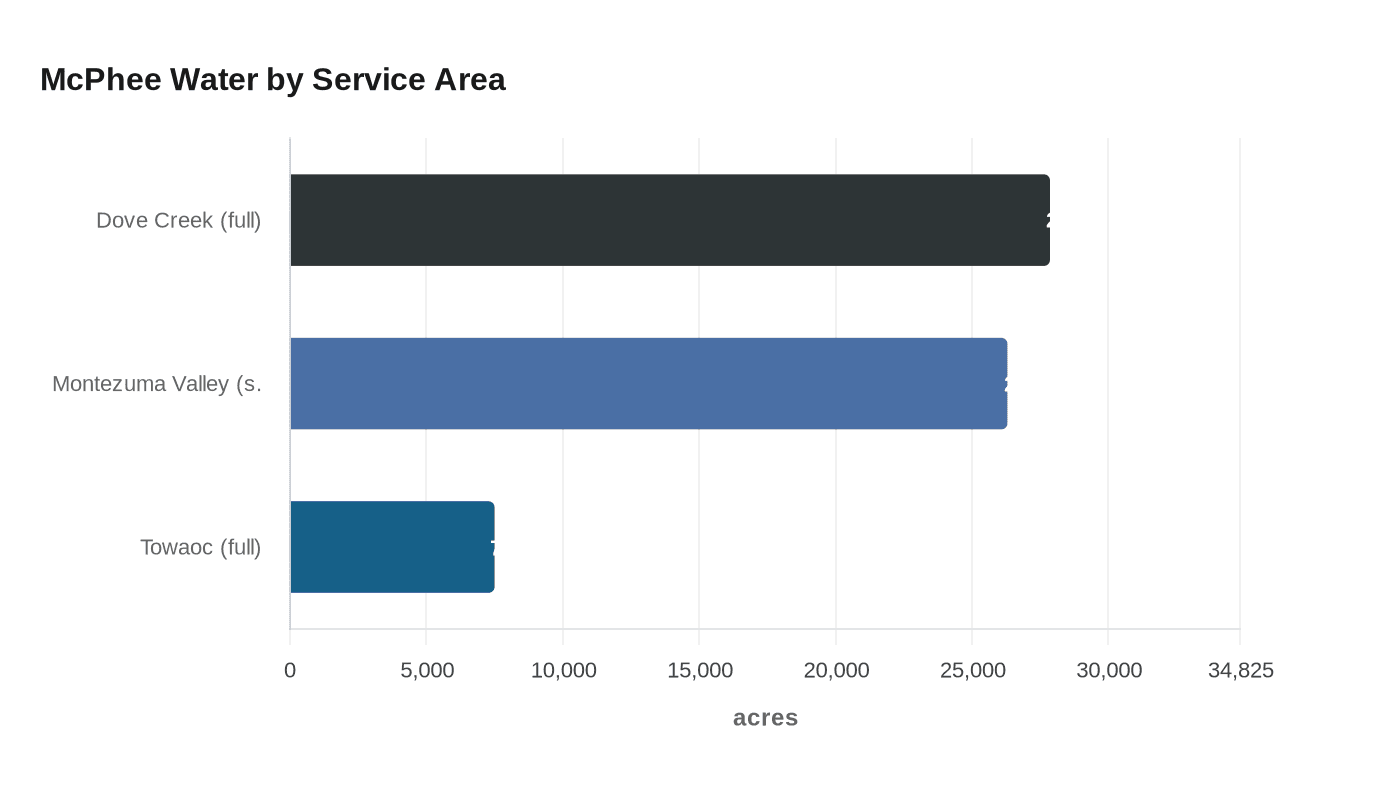
The annual supply is distributed with precision. An average annual supply of 90,900 acre-feet of water is provided to 27,860 acres of full service land in Dove Creek, 7,500 acres of full service land in Towaoc, and 26,300 acres of supplemental service land in Montezuma Valley. That breakdown reflects not just geography but the layered legal obligations the project was built to fulfill.
For municipal and industrial users, the project carries an 8,700 acre-foot allocation that "will permit a moderate, but healthy, future growth rate for the area." In 1996, residents of the Dolores Water Conservancy District took that commitment further: the DWCD electorate voted to tax itself to cover the repayment cost of excess Cortez and Dove Creek municipal supplies, ensuring a sufficient water supply for the entire community going forward.
Tribal Water and a Unique Federal Obligation
The Dolores Project carries a legal distinction that sets it apart from virtually every other Bureau of Reclamation project in the West. It took over 100 years to deliver clean, reliable water to the Ute Mountain Ute Reservation. The Dolores Project is one of two water projects constructed as a result of the Colorado Ute Indian Water Rights Settlement Act of 1988.
In exchange, the tribe received allocations from the Dolores Project that brought drinking water for household use and economic development to the tribal community of Towaoc for the first time. In addition to providing household taps for tribal residents, the original plan also included the construction of an irrigated 7,600-acre farm and ranch.
For the Ute Mountain Ute Tribe, the settlement meant access to Dolores Project water, an entitlement to Animas-La Plata Project water, and rights to over 27,000 acre-feet of water from rivers that flow near or through their reservation. The Bureau of Reclamation designed the full service irrigation delivery system for maximum efficiency specifically to stretch the available water supply and assist in settling the tribe's reserved water rights claims, an engineering and legal achievement built into the bones of the project from the start.
Carry-Over Storage: The Safety Net for Dry Years
McPhee Reservoir stores most of the flow of the river throughout the entire year, with spills only occurring during spring in years when the reservoir cannot store all the inflows. Over the past 30 years, annual inflows into McPhee Reservoir have averaged 327,000 acre-feet. Inflows can vary greatly year to year; in the drought of 2002, annual inflows totaled merely 79,757 acre-feet, whereas just three years later in 2005, recorded inflows were up to 516,457 acre-feet.
That range makes carry-over storage one of the most critical functions the reservoir performs. All Dolores Project users benefit from McPhee Reservoir carry-over storage, allowing the conservation of water during years of plenty for use during the inevitable dry years. Carry-over storage is critical to sustain a viable agricultural economy and guarantee a reliable community domestic supply. Without that buffer, a single drought year could devastate both farms and households across the region.
Fisheries, Recreation, and Wildlife
A quality catch and release trout fishery has been created below the dam with releases of water from McPhee Reservoir. When reservoir inflow is high enough during spring runoff, releases will be made for white-water rafters. Today, the reservoir and boat ramps, campgrounds, roads and other constructed facilities have created recreational opportunities for the enjoyment of the public.
The Dolores Project also includes a storage allocation for a fishery pool that provides for perennial baseflow below the dam. The McPhee Dam facility operates year-round on fishery releases from McPhee Reservoir, while the Towaoc Canal plant operates from April to October on the irrigation water supply conveyed through the canal.
Dawson Draw Reservoir, located west of McPhee Reservoir, was constructed specifically for fish and wildlife enhancement and is supplied primarily from irrigation return flows. Dawson Draw and Totten Lake together receive a combined average of approximately 800 acre-feet of project water annually from McPhee Reservoir through existing facilities, supporting waterfowl habitat and new lake fisheries that the project created. Project funds also provided for the acquisition and improvement of land north and east of the Dolores River for winter range, helping to offset big game habitat losses caused by project construction.
Fishing is open year-round at the reservoir, with species including walleye, small and largemouth bass, trout, crappie, northern pike, perch, and kokanee salmon. The reservoir is stocked with both warm and cold-water fish.
Hydroelectric Power
Powerplants are located on McPhee Dam and the Towaoc Canal to generate an annual average of 36,578,000 kilowatt-hours, which enters the Colorado River Storage Project power transmission system. That figure represents more energy than the project itself requires to operate. Over the last ten years, the Dolores Project has generated enough power to supply (on average) 2,706 U.S. homes.
Who Manages It All
The Dolores Water Conservancy District administers project and joint-use facilities within its boundaries, and the Ute Mountain Ute Indian Tribe and the Bureau of Indian Affairs administer facilities serving the reservation. The Forest Service, Bureau of Land Management, and Colorado Division of Wildlife participate in managing recreational and cultural facilities and wildlife lands.
A Project Built on Competing Priorities
The Dolores Project was the last federal project constructed as part of the Colorado River Storage Project until the completion of the Animas-La Plata Project in 2011. That distinction underscores just how much was riding on McPhee: it had to serve farmers in Dove Creek, supplement irrigation across Montezuma Valley, fulfill a century-old tribal water obligation, sustain a river fishery, generate clean hydropower, and protect downstream landowners from floods, all from a single reservoir in the canyon above the town of Dolores.
When full, McPhee Reservoir covers an area of 4,470 acres. It extends 10 miles up the Dolores River, 4 miles up Beaver Creek, 1 mile up Dry Creek, 2 miles up House Creek, and 2 miles across the Sage Hen flats. That physical footprint tells only part of the story. The full reach of what McPhee does stretches far beyond the waterline: into dry-land fields, through kitchen faucets, across reservation boundaries, and down a river where trout hold in cold currents maintained by deliberate releases from behind the dam.
Know something we missed? Have a correction or additional information?
Submit a Tip
