AI Camera Alerts Contain Wildfire Near Turtle Mountain, Protecting Douglas County
A Pano AI equipped camera detected a lightning strike fire in a remote section of Douglas County wilderness on December 22, 2025, and sent live footage and coordinates that helped crews locate and suppress the blaze. The rapid detection and coordinated use of helitack and county aerial resources contained the fire in under four hours, underscoring the local value of camera networks and regional support for aerial firefighting.
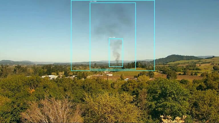
A lightning strike ignited a remote wildfire near Turtle Mountain on December 22, 2025, and an artificial intelligence enabled Pano AI camera in the county’s monitoring network detected smoke and sent alerts with precise coordinates to first responders. The Douglas County Office of Emergency Management used the live imagery to route the helitack crew and the county firefighting helicopter, allowing firefighters to reach the remote site on foot in about two hours, put the helicopter over the fire within roughly 30 minutes, and contain the blaze in under four hours.
Douglas County Office of Emergency Management director Mike Alexander said the alert provided live footage and a precise location that sped response and helped crews focus resources. The quick detection and accurate triangulation of smoke cut hours off what can be a much longer search in rugged terrain, reducing the chance that a small ignition becomes a much larger incident that threatens homes, infrastructure, ranchland and recreation areas.
The county’s camera network has grown to about a dozen units in and near Douglas County, funded through partnerships with local utilities including Xcel Energy and Core, and employing Pano AI technology to triangulate smoke and supply coordinates. Commissioner Abe Laydon, founder and chair of the Douglas County Wildfire Action Collaborative, emphasized the value of combining that technology with the county’s helitack and aerial firefighting capability. Laydon said the county has pursued investments in aerial wildfire response and is seeking regional support to sustain and expand those resources.
For residents, the episode highlights two practical benefits. Faster detection and precise coordinates reduce response times and lower suppression costs, and they also improve public safety by limiting smoke exposure and the potential need for evacuations. The event also illustrates how local investments and partnerships with utilities and technology providers can multiply the effectiveness of limited firefighting assets in rural terrain.
As Douglas County evaluates next steps, officials will weigh continued camera deployment and broader regional cooperation for aerial resources to ensure similar incidents remain small and contained. The December 22 response demonstrated how combining modern detection tools with trained local crews can protect communities and natural landscapes in high risk areas.
This article was produced by Prism’s automated news system from verified source data, official records, and press releases, then run through automated quality and moderation checks before publishing. The system is built and supervised by the people who set the standards it runs under. Read our full AI policy.
Did this article answer your question?