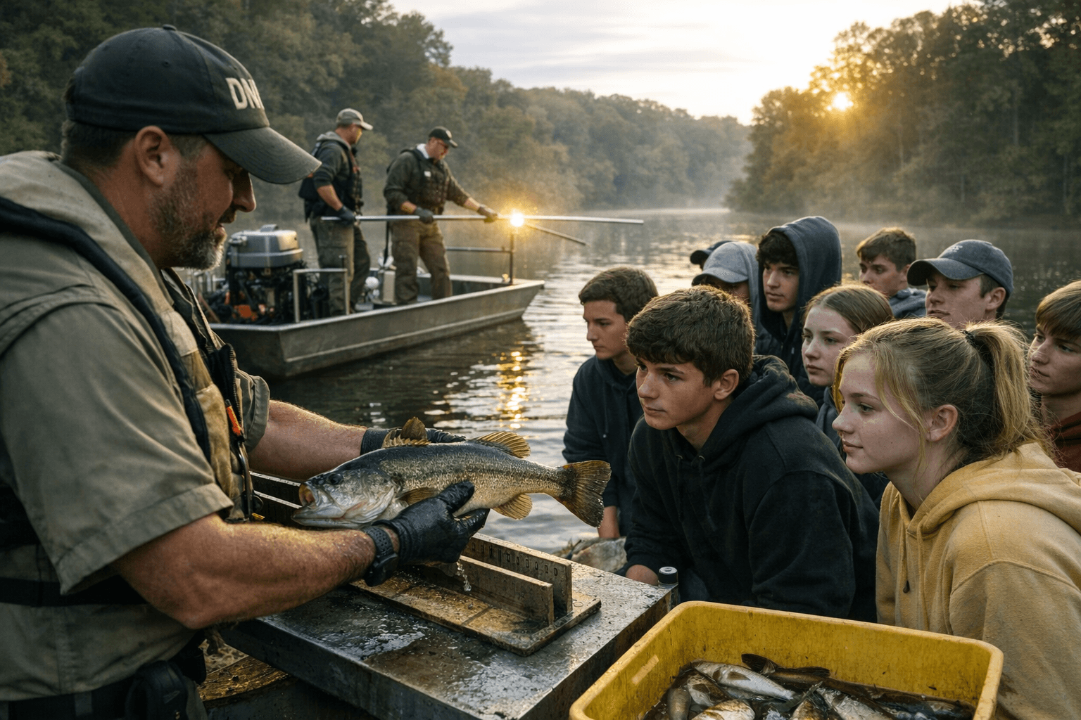
Jasper High students learn DNR fish surveying at Huntingburg Lake
About 70 Jasper High students saw DNR biologists stun, measure and release fish at Huntingburg Lake, where access and fish quality affect local anglers.
About 70 Jasper High School students got a close look at the kind of fish survey work that helps shape what local anglers find at Huntingburg Lake and other Indiana waters. The visit showed how the Indiana Department of Natural Resources checks native fish communities, habitat and water quality, work that matters not just to science students but to families who fish, and to the bait shops and sporting-goods stores that depend on steady outdoor recreation.
The students, from AP Biology and Environmental Studies, spent Tuesday at Huntingburg Lake learning how DNR biologists conduct field surveys on lakes and ponds. They were shown how the boats’ electrical current is used to temporarily stun fish, then watched as biologists collected the fish for study. The lesson moved well beyond the classroom, giving Jasper High students a direct look at how conservation science happens in a real Dubois County waterway.
Indiana DNR says standardized fish community surveys are completed each May and June using trap nets, gill nets and nighttime electrofishing. Captured fish are identified, measured and immediately returned to the lake. The agency says it has completed fish community surveys at hundreds of natural lakes and man-made lakes since 2010, building a long-running record that helps track whether lakes are changing and whether fish populations remain healthy.
That record includes Huntingburg Lake itself. A DNR bathymetric survey dated June 7, 2011 lists the lake at 181 acres, underscoring that this is a closely monitored public waterbody, not just a scenic stop for a school outing. DNR’s Where to Fish map also notes that public access sites are approximate and should be confirmed before launching, a practical reminder for boaters and shoreline anglers who depend on local access points being open and usable.
The broader value of the trip is that it tied a familiar place in Huntingburg, Indiana, to the same survey methods used statewide. Indiana’s fish-surveys data, preserved in the Indiana Data Hub, now cover 2010 through 2025, showing how this work feeds a continuing scientific record. For Dubois County, that means the health of a lake can shape catch quality, recreation and spending, all from data gathered one fish at a time.
This article was produced by Prism’s automated news system from verified source data, official records, and press releases, then run through automated quality and moderation checks before publishing. The system is built and supervised by the people who set the standards it runs under. Read our full AI policy.
Did this article answer your question?