Goochland Fire-Rescue Dashboard Gives Residents Live Emergency Response Updates
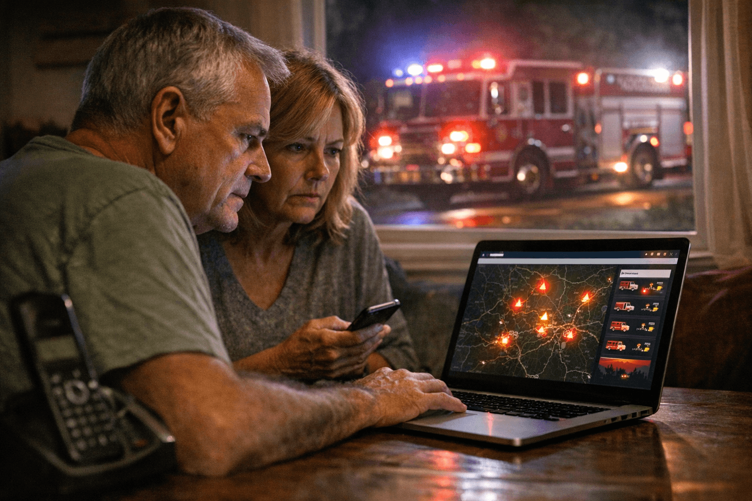
A live incidents heat map and real-time crew tracker on the Goochland Fire-Rescue website let residents see exactly where crews are deployed before picking up the phone.
Goochland's geography has always made emergency response a complex equation. Spread across hundreds of square miles of semi-rural landscape, with a mix of career and volunteer Fire-Rescue staffing covering everything from interstate corridors along I-64 to back-country roads with no formal addresses, the county has long faced the communication challenge every rural jurisdiction knows: when something happens, neighbors want to know what's going on.
The Goochland Department of Fire-Rescue has answered that with a public-facing live response dashboard that gives any resident with a smartphone a real-time window into active incidents across the county.
What the Dashboard Shows
The live dashboard is built around transparency. It displays an interactive incidents heat map, current response status, call types, and aggregated statistics that update as crews respond. If units are staged near a structure fire on a rural route or working a multi-vehicle crash on I-64, that activity appears on the dashboard in real time, along with enough context to understand why nearby resources may already be committed.
The heat map feature is particularly useful for understanding response geography. Because Goochland covers a large area with varied population density, response times naturally differ from the Route 250 corridor to the more remote western reaches of the county. The dashboard makes that context visible rather than leaving residents to wonder why an engine hasn't arrived yet. The department and county encourage bookmarking the site for exactly this kind of situational awareness.
When to Call 9-1-1 and When Not To
The dashboard is a transparency tool, not an emergency communication channel. For any life-threatening situation, call 9-1-1 immediately: unconscious person, severe bleeding, chest pain or shortness of breath, active fire, or crime in progress. The dashboard should never delay that call.
For everything that doesn't require lights and sirens, the Fire-Rescue website lists non-emergency contact numbers and public education resources. Those lines handle:
- Reporting non-urgent safety concerns
- Requesting smoke detector installation assistance
- Inquiring about burn permits
- Signing up for CPR classes or community education programs
Knowing which number to use matters in a county where call volume during a major storm or highway incident already stretches resources. Routing routine questions through non-emergency lines keeps the 9-1-1 system available for calls where seconds count.
Using the Dashboard During Storms and Road Incidents
Where the dashboard earns its keep is during the kind of widespread, slow-moving events that generate high public anxiety and repetitive call volume: winter storms, flooding, roadway hazardous-material responses, or planned controlled burns that produce visible smoke across multiple neighborhoods.
Checking the dashboard before calling dispatch gives residents the situational context to make better decisions: whether a road closure is being actively worked, whether mutual-aid resources from neighboring jurisdictions have been called in, or whether a smoke column is a permitted agricultural burn rather than a structure fire. County NewsFlash posts complement the dashboard during these events, providing official instructions, shelter locations, and evacuation guidance when conditions escalate.
Signing Up for CodeRED Alerts
The dashboard shows what's happening; CodeRED tells you directly when something affects your address. Goochland County maintains the CodeRED alert system and distributes updates through official county channels. Registration takes only a few minutes through the Goochland County official website.
The county's NewsFlash system runs parallel to CodeRED, publishing announcements about road closures, community meetings, and developing incidents. Many of those posts include direct links to register for alerts and list dedicated email addresses for residents with follow-up questions. Both systems together cover the two most common needs during an emergency: knowing it's happening and knowing what to do next.
Registration is worth auditing at least once a year. Phone numbers and email addresses change, and an outdated contact record means an alert goes nowhere when it matters most. If you have a medical-alert subscription through a private provider, it's worth a conversation with them about how Goochland Fire-Rescue's local protocols interact with their monitoring service.
Practical Steps for Every Household
Goochland's rural character creates a specific challenge for callers reporting emergencies from unfamiliar roads: describing your location clearly. Many county roads lack highly visible signage, and rural route addresses don't always translate intuitively into GPS directions for approaching units. A few habits close that gap:
1. Save 9-1-1 in your contacts so it's accessible under stress, not just by memory.
2. When calling from a rural road, lead with a landmark, mile marker, or GPS coordinates. On I-64, mile markers are the fastest location reference for first responders.
3. Keep three bookmarks on your phone: the Goochland Fire-Rescue dashboard for situational awareness, the county NewsFlash page for official advisories, and Virginia 511 for real-time road conditions and closure information.
4. Confirm your CodeRED registration once a year, especially after a phone number or email change.
A County Investing in Public Transparency
Goochland Fire-Rescue's decision to publish a live response dashboard reflects a broader shift in how local emergency management agencies approach public trust. By making active incident data visible rather than keeping it internal, the department reduces the anxious "what's happening out there?" calls that flood non-emergency lines during large incidents, and it gives residents the context to make practical decisions rather than waiting passively for official word.
For a county that spans the distance it does, with the staffing mix it carries, that transparency is a practical tool for a community that has to work alongside its emergency services. The Goochland Fire-Rescue website hosts the dashboard, department contact information, and community program listings. If you spot an error on any public dashboard, the posted contact details are the right channel to flag it for correction.
This article was produced by Prism’s automated news system from verified source data, official records, and press releases, then run through automated quality and moderation checks before publishing. The system is built and supervised by the people who set the standards it runs under. Read our full AI policy.
Did this article answer your question?
