Boardman Lake Loop Offers Traverse City Residents Four Miles of Year-Round Recreation
Four miles around Boardman Lake, the "BLT" trail connects Traverse City's library, breweries, and waterfront through woods, boardwalks, and kayak launches.

Four miles. That's all it takes to circle Boardman Lake, pass two breweries, cross a river twice, spot a swan, and end up exactly where you started, feeling like you've been somewhere worth going. The Boardman Lake Loop Trail, known around town simply as the "BLT," has quietly become one of Traverse City's most complete recreational assets: a fully accessible, beginner-friendly loop that threads together the city's parks, neighborhoods, institutions, and waterfront into a single continuous path just south of downtown.
Known locally as the "BLT," the trail connects several local businesses, public parks, and valuable community assets, including the Traverse Area District Library. It took years of collaboration among the City of Traverse City, Grand Traverse County, Garfield Township, and TART Trails to close the loop. For decades, the east shore segment terminated near Medalie Park at the southern end, leaving the western shore unconnected. TART's staff, volunteers, and community members invested countless hours over several years to continue the trail over a narrow section of the lake and along a substantial section of the western shore, ultimately connecting to existing trail infrastructure near 14th Street. A TrailLink user marked the milestone in October 2022, posting simply: "Now completed!"
A Loop Built for Everyone
The BLT checks nearly every box for inclusive trail design. TART Trails describes it as fully ADA accessible, and TrailLink lists it as wheelchair accessible. With less than 100 feet of total elevation gain across its four miles, the difficulty rating is firmly beginner, making it equally welcoming to a grandparent on a slow walk and a parent pushing a stroller on a Tuesday morning. Cross-country skiers can use the trail in winter, extending the loop's usefulness well beyond the warm-weather months that define most northern Michigan trail activity.
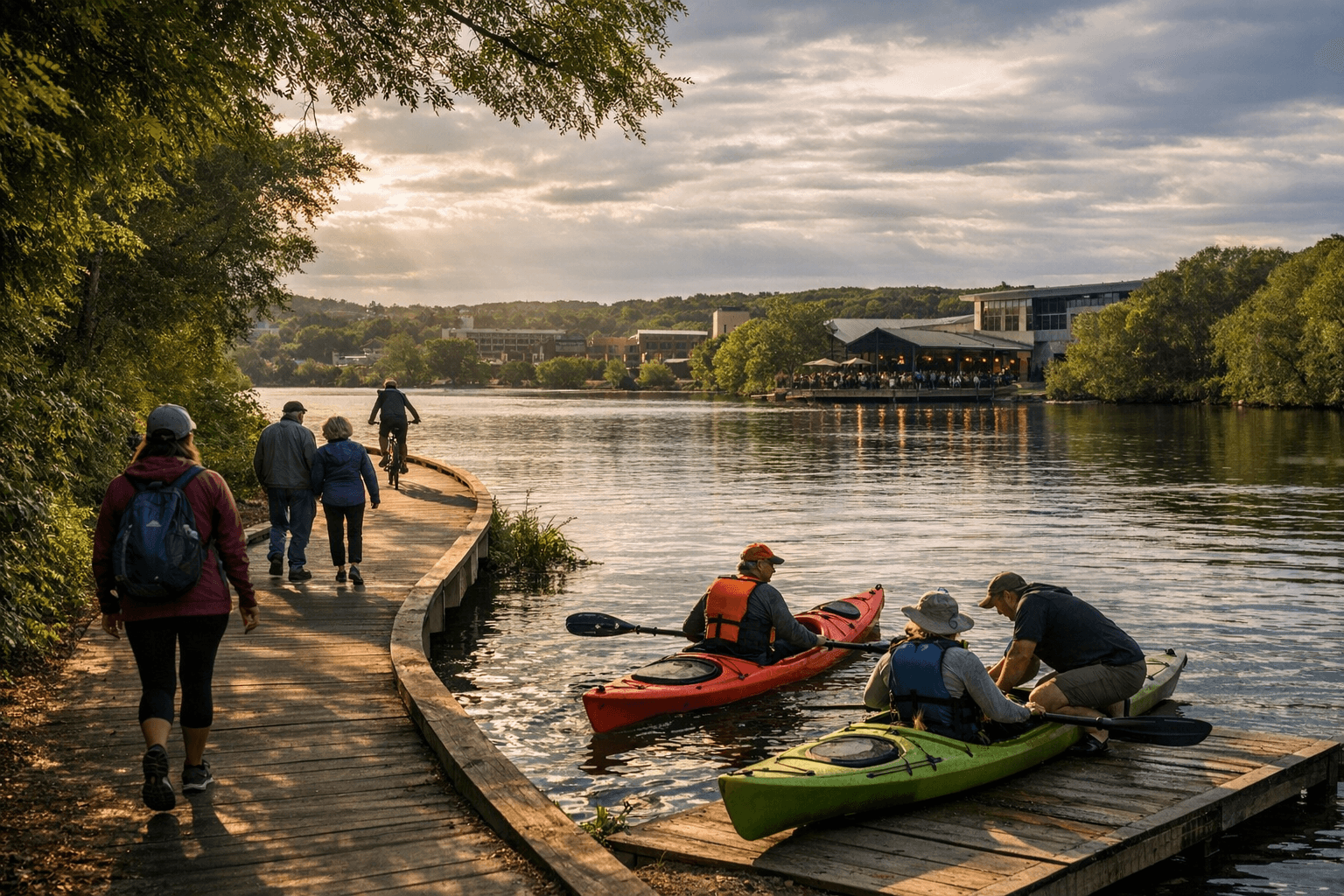
Surface variety is part of what makes the trail feel like four distinct experiences stitched into one. Sections run on asphalt, concrete, and pavement; others transition to boardwalk, wooden bridges, and crushed limestone or crushed stone; a small stretch of hard-packed dirt and gravel completes the mix. The southern end includes an extended boardwalk over Boardman Lake Cove with bump-out sections designed for rest and recreation. Two bridges carry walkers and cyclists across the Boardman/Ottaway River, and the western shore features lookout piers, fishing decks, and kayak launches that turn a casual lap into something closer to a waterfront experience.
The Route, Segment by Segment
The northern portion of the loop runs closest to downtown, offering an urban character with commercial access. This stretch puts trail users within easy reach of Oryana Community Co-op, The Filling Station Microbrewery, and Right Brain Brewery, along with other businesses in the area. It's also where the trail connects to NMC's University Center and Logan's Landing, and where Cass Road businesses link south toward the Boardman/Ottaway River Trail.
The eastern segment is the trail's oldest and, for many regulars, its most beloved. The woods close in, the city noise falls away, and the lake stays visible through the trees for nearly the entire stretch. As MyNorth described it: "Slip into the woods on the east side of the lake. This is the oldest part of the trail and truly serene. You feel like you are away from it all and thoughts of the city disappear. It's shaded and you can see the lake every inch of the way. Watch for swans and those sailboats I told you about, plus golden retrievers out walking their owners."
The southern end is where the trail's engineering ambition becomes most visible. The extended boardwalk over Boardman Lake Cove, with its bump-out rest areas, represents the infrastructure that finally closed the gap that had frustrated trail users for decades. Medalie Park sits here, offering parking and access to Logan's Landing. The western segment completes the circuit with lookout piers and fishing decks that face back across the water, giving the final stretch a sense of arrival before the trail returns to its northern, urban character.
Where to Start and How to Park
Hull Park, tucked behind the Traverse Area District Library off Hannah Road, is a natural starting point. There's typically ample parking, and the boat launch nearby often hosts young sailors heading out onto Boardman Lake. Setting out counter-clockwise from Hull Park, heading west first, means saving the serene eastern woods for the second half of the loop, an arrangement that builds toward the trail's quietest and most scenic stretch.
Three main access zones serve different parts of the loop:
- Northwest access: Oryana 10th St Trailhead, with additional parking at 8th St, Lake St, and 14th St.
- Northeast access: Off Hannah Road, just south of the Traverse Area District Library (Hull Park).
- South access: Medalie Park in the Logan's Landing area, off South Airport Road.
Trail endpoints, as listed on TrailLink, are E 10th St & Lake Ave and South Airport Rd & Park Dr.
Restrooms are available seasonally at Hull Park and Medalie Park via porta-lets, and year-round inside Oryana Co-op for those starting or finishing on the northwest side of the loop.
Getting There on Two Wheels
Cycling is one of the loop's most popular uses, and several local shops are positioned to help whether you need a rental, a tune-up, or advice on where to ride. Brick Wheels, City Bike Shop, and McLain Cycle and Fitness are all conveniently located near the trail and are recognized as local champions for cyclists in the area.
TrailLink reviewer michael.g.ocallaghan, who has ridden the loop "multiple times at different times of the year," described it simply: "It's a nice easy 4 mile loop. It's pleasant seeing people pushing their babies in strollers, riding bikes, and walking, and enjoying this beautiful scenery." Another reviewer, jencichoski, called it "a very nice addition to TC" and recommended it to anyone looking to "get out of the (relative) hustle and bustle of downtown traverse."
The Partnership That Made It Happen
The BLT is owned by the City of Traverse City in partnership with Grand Traverse County and Garfield Township. TART Trails collaborates with all three entities to support the trail's development and ongoing maintenance. The result is a piece of public infrastructure that functions simultaneously as a fitness amenity, a transportation corridor, a wildlife corridor, and a connector between some of the city's most-used community institutions.
For maps, downloadable GPX files, and current trail information, TART Trails maintains details at traversetrails.org. TrailLink also hosts the trail under ID 6863548, where users can download a GPX file, print a trail map, and read the growing archive of reviews that document the loop's evolution from a partial east-shore path into the complete circuit it is today.
A four-mile walk or ride around Boardman Lake won't take most people more than two hours, but the combination of wooded solitude on the east shore, waterfront infrastructure on the south and west, and neighborhood connectivity on the north makes it feel like considerably more than a simple loop around a lake.
This article was produced by Prism’s automated news system from verified source data, official records, and press releases, then run through automated quality and moderation checks before publishing. The system is built and supervised by the people who set the standards it runs under. Read our full AI policy.
Did this article answer your question?


