FEMA Draft Maps Significantly Expand Harris County 100-Year Floodplain Footprint
FEMA released draft maps expanding Harris County's 100-year floodplain footprint, potentially changing insurance, permitting and property risk for many neighborhoods.

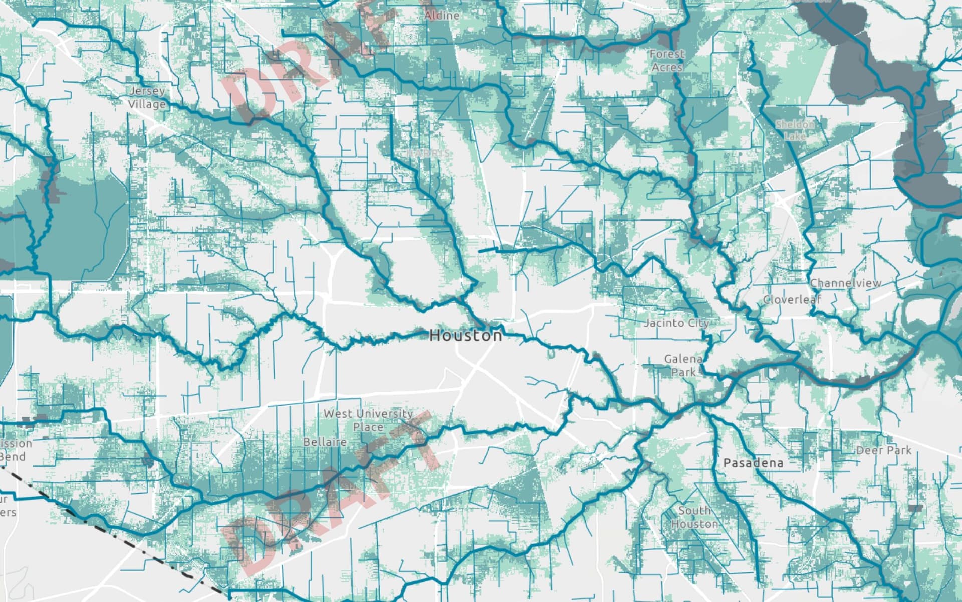
FEMA has posted draft floodplain maps for Harris County that substantially expand areas shown as subject to 100-year flooding, a change driven by updated rainfall estimates, newer topography and advanced modeling. The draft maps are an early version and do not immediately alter flood insurance requirements or development regulations, but they lay out a different baseline for risk that could reshape insurance, permitting and property decisions if finalized.
The mapping uses Atlas 14 rainfall data and MAAPNext modeling, a FEMA-led initiative supported by the Harris County Flood Control District. FEMA and local engineers incorporated higher rainfall rates, updated ground elevations and modern hydrologic analysis. The traditional 24-hour 100-year rainfall estimate of about 13 inches is now closer to 17 inches in parts of the county, a change described as more than a 30 percent increase in rainfall rates. Harris County already uses MAAPNext outputs and the Harris County Flood Education Mapping Tool to explore forward-looking inundation scenarios.
Estimates of how much the 100-year floodplain will grow vary. A Houston Chronicle analysis found the 100-year floodplain could increase by about 130 square miles, a 43 percent rise, while the 500-year floodplain could grow by about 62 square miles and mapped floodways could shrink by roughly 5 percent. County engineers cited by JRH Engineering describe the 100-year footprint expanding from roughly 150,000 acres to around 200,000 acres. Converting acres to square miles shows those acreage figures imply an increase of about 78 square miles; the two published estimates differ numerically but both signal substantial expansion.
The draft maps show notable increases along multiple bayou corridors and around reservoirs. Greens Bayou and Halls Bayou, including upper reaches of those watersheds, are flagged as expanded, as are parts of Keegans Bayou and Brays Bayou in southwest Houston. The backside of Addicks Reservoir and some Bellaire blocks appear on the new maps, and Kingwood and other areas where Houston crosses the county line see new floodplain designations. At the same time, some areas show smaller floodplain footprints; Woodell says the maps “reflect much of the mitigation progress already made since Harvey... reflect the benefits of flood-mitigation projects completed or under construction through 2020,” and that “Elm Grove and Mills Branch floodplains shrank considerably.” Local mitigation cited includes projects funded by the 2018 Bond Program and detention basins developers built at Woodridge Village before transferring them to the flood control district.

Local officials and analysts emphasize process and potential impacts. Blackburn said, “I would flag the northeast part of town, from what I saw. Greens and Halls Bayou flood plains look like they expanded significantly.” Insurance advocates warn many homeowners could face new costs; Brody observed, “People who didn't have to have flood insurance before are all suddenly going to be hit with potentially thousands of dollars.” Harris County engineer Milton Rahman said once maps are approved, “the county will have the best flood data in the region and should ask FEMA for more flood insurance discounts for its residents.”
The maps were posted after years of delay in a mapping effort that began after Hurricane Harvey and follow the last comprehensive county maps issued in 2007. FEMA is soliciting feedback from local officials before a broader public review and formal adoption process. Residents should review their properties on FEMA’s online draft maps and the county’s mapping tool, contact the Harris County Flood Control District or their insurance agent with questions, and watch for announced public comment and appeal dates. How regulators and insurers adopt the draft boundaries will determine whether these new lines translate into higher premiums, new permit conditions or changes in property values.
This article was produced by Prism’s automated news system from verified source data, official records, and press releases, then run through automated quality and moderation checks before publishing. The system is built and supervised by the people who set the standards it runs under. Read our full AI policy.
Did this article answer your question?