Navigation Boulevard underpass floods again, cutting off east Houston route
A low underpass on Navigation Boulevard flooded again after modest rain, blocking an east Houston shortcut and renewing questions about why it keeps failing.
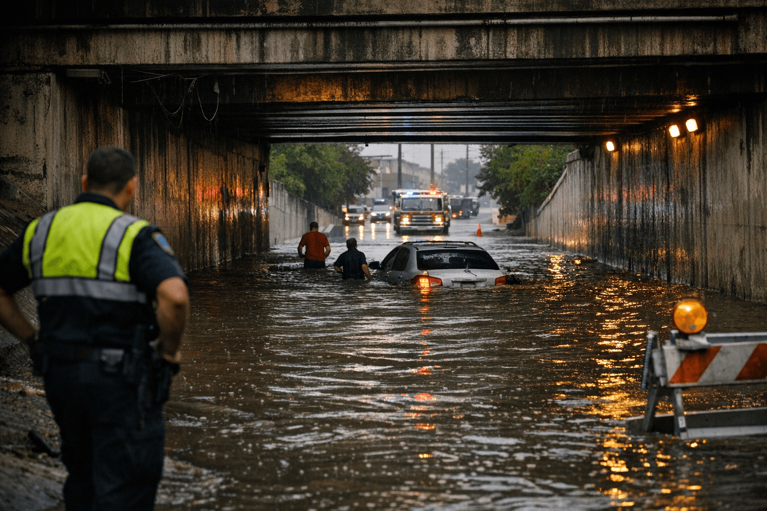
A low underpass on Navigation Boulevard filled again after only modest rain, cutting off a key east Houston route and sending drivers into detours through a corridor many residents already know can fail fast.
The repeated flooding has turned the Navigation Boulevard and Franklin Street crossing in east Downtown Houston into a practical test of the city’s drainage system. It is the kind of spot that can stall commutes, slow buses, and force businesses and workers to reroute around standing water even when the rain is not severe.
Houston Public Works says it is responsible for streets and drainage across 671 square miles of the city, including about 3,900 miles of stormwater lines. The department’s Transportation & Drainage Operations and Stormwater Planning teams are supposed to maintain those systems, identify drainage deficiencies and move projects toward rehabilitation and reconstruction. Houston says it is also developing its first Stormwater Master Plan, a modeling effort meant to pinpoint trouble spots before they become repeat closures.
The city’s response framework exists, but it is built for long timelines. Houston’s Storm Water Action Team, created in 2017 after Hurricane Harvey, was designed to reduce localized drainage problems that are not directly tied to river or bayou flooding. The city says SWAT and the Local Drainage Program typically have a 12- to 18-month turnaround. That leaves little comfort for drivers who are already dealing with the same underpass every time a storm system passes through.
The Navigation and Franklin underpass was already on the city’s list of flood-prone locations. KHOU reported on June 12, 2025, that about 2.5 feet of water accumulated there and that a driver had to be rescued after getting stuck. Houston officials said barricades are generally pre-staged when 4 inches or more of rain are forecast, and Public Works was evaluating a more permanent manual gate as a longer-term fix. ABC13 also reported on June 6, 2025, that heavy rain again blocked roads on Navigation Street east of downtown.
Residents have another tool for pressing the issue: Houston’s 311 flooding heatmaps, which are updated every 15 minutes and track complaints over the past 24 hours, 72 hours, 30 days and 12 months. For a low underpass that keeps closing after relatively little rain, those complaints now point to a larger question. The problem may be the road’s design, a maintenance lapse, or a drainage bottleneck that still has not been fixed.
This article was produced by Prism’s automated news system from verified source data, official records, and press releases, then run through automated quality and moderation checks before publishing. The system is built and supervised by the people who set the standards it runs under. Read our full AI policy.
Did this article answer your question?