Humboldt Bay Boaters Guide: Tides, Slips, and Harbor Safety Tips
Humboldt Bay's tidal swings can ground a skiff before lunch: here's which marina to use, what it costs, and the bar-crossing mistake that catches most visitors off guard.
A skiff bottoming out on a Humboldt Bay mudflat twenty minutes after launch is not a mechanical breakdown story. It is a tide chart story. The Humboldt Bay Harbor District's patrol staff field that call often enough that it might as well be the unofficial opening line of any local boating guide: on this bay, the water visible at noon can disappear by 3 p.m., and a hull drawing as little as two feet can embed itself in soft mud off the Eureka waterfront when the tide bottoms out.
Whether you are trailing a 17-foot skiff down for a half-day on the water, scouting a permanent berth for a larger vessel, or arriving by sea for a one-night transient stop, the choice of facility, the cost, and the timing of your approach all connect back to the same tidal reality that has shaped how this bay is used for generations.
Two Main Marinas, Six Ramps: Knowing Where to Go
Humboldt Bay's two primary marina facilities serve distinctly different user profiles. The City of Eureka operates the Eureka Public Marina on the downtown waterfront, reachable at (707) 268-1973. It holds roughly 150 covered moorage slips, accommodates vessels between 20 and 100 feet in length, and has 18 dedicated car-and-trailer parking spaces alongside a fuel dock, pump-out station, and launch ramp. Its location puts it within walking distance of downtown Eureka's shops and restaurants, making it the practical first choice for day-trippers and trailered boats.
The Woodley Island Marina, operated by the Humboldt Bay Harbor, Recreation and Conservation District, is the largest marina on the bay and its most full-featured facility. Situated on Woodley Island near the center of the bay, it serves commercial fishing vessels, research craft (including the research vessel Coral Sea, which calls Woodley home), and recreational boats from the same basin. Slips come with access to a café, laundry, chandlery, hoists, and a dedicated work area. The marina office can be reached at 707-443-0801. Notably, the National Weather Service forecast office, the U.S. Coast Guard, and the Army Corps of Engineers Eureka field station are all headquartered on Woodley Island, giving the facility an unusual concentration of maritime authority within a short walk.
Beyond the two marinas, improved launch ramps are spread around the bay's perimeter: at Fields Landing to the south, near the Coast Guard Station on the Samoa Peninsula, at the Eureka Bridge ramp under the southern end of the Samoa Bridge off Waterfront Drive, and at Hookton Slough on the Humboldt Bay National Wildlife Refuge. The Hookton Slough ramp is restricted to non-motorized watercraft only. The Arcata Marsh ramp at the bay's northern end is particularly shallow and becomes usable only during higher tidal stages.
Scenario One: Launching a Skiff for the Day
For a small outboard skiff, the Eureka Public Marina ramp and the Samoa Peninsula ramp near the Coast Guard Station are the most practical entry points. The Eureka ramp's 18 car-and-trailer spaces are a hard ceiling, not a suggestion; on summer weekends they fill before 8 a.m. Arriving late means circling or retreating to the Eureka Bridge ramp under the Samoa Bridge as a backup.
Tide timing is not optional. The marina's own guidance specifically flags vessels drawing more than about two feet as vulnerable to grounding on the approach and within the basin during low or negative tides. Humboldt Bay routinely sees tidal swings of six to seven feet, with predicted lows regularly touching -0.7 feet. A shallow-draft skiff launched on a falling tide can find itself sitting in mud before the operator has motored out of sight of the ramp. Plan your launch window around mid-to-high water, not around what time you happened to wake up. Shore gusts off the North Coast complicate docking on return; have fenders rigged and dock lines staged before you reach the slip, not while you're being pushed sideways toward a piling.
Scenario Two: Keeping a Slip
Longer-term moorage at Woodley Island Marina currently operates with a waiting list for permanent slips. The Harbor District's process requires a completed lease application, proof of vessel seaworthiness, current registration, liability insurance, an initial deposit of one month's rent plus a matching security deposit, and a valid credit card on file. Monthly rent is due the first of each month. Current rate schedules are published by the District, and the marina office can walk you through the wait list process and insurance requirements. Given that the waiting list is active, anyone planning a move to a permanent Humboldt Bay berth should start that conversation well before they need the slip.
The Eureka Public Marina handles its own slip assignment process separately and is the contact for both transient and potentially longer-stay moorage inquiries at (707) 268-1973. Demand from commercial fishing traffic, crabbers, and aquaculture operators means availability at both facilities fluctuates with the season. Calling ahead is not a formality; it is how you avoid arriving with a boat and no place to put it.
Scenario Three: Arriving by Water for a Day Visit
Transient boaters approaching from outside the bay should contact Woodley Island Marina before docking. The marina monitors VHF Channel 14, which is its primary hailing and working channel; hailing on 14 before entry is standard local practice and the fastest way to get a slip assignment and confirm berth availability. The marina strongly encourages advance reservations for transient moorage rather than showing up and hoping for space. The Eureka Public Marina also handles transient vessels and can provide slip assignments and local tide guidance on contact.
Day visitors by boat will find Woodley Island worth the stop beyond the slip itself. The embarcadero walkway, the Café Marina, the Table Bluff Lighthouse dating to 1892, and the well-known Fisherman statue are all within a short walk of the docks. A passport stamp is available at the marina office for those keeping travel records.
The Tide and Current Gotchas
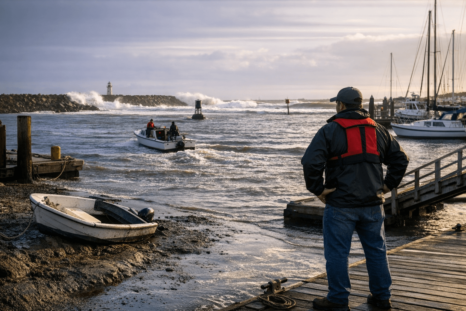
The Humboldt Bay bar carries the second-worst reputation for danger on the entire Pacific Coast, behind only the Columbia River bar. The channel into the bay runs between rock jetties at the ocean entrance, and the interaction of ocean swell with tidal current creates breaking conditions that have capsized fishing vessels, destroyed hulls on the jetties, and ended lives.
The single most well-documented error the harbor patrol and Coast Guard encounter: a boater exits on a high tide ahead of the ebb, spends five or six hours on the water, and then attempts the bar crossing inbound against a strong outgoing tidal current with a large following sea building behind the stern. Small boats are acutely vulnerable to broaching in that configuration. Before any bar crossing, call the U.S. Coast Guard Station at 707-443-2212 or raise them on VHF Channel 22A for a live bar conditions report. The National Weather Service Eureka office also maintains a bar camera on its website, accessible from weather.gov/eureka, allowing a visual check of conditions before committing to the entrance.
Fog compounds the timing problem. The North Coast marine layer moves in and out without much warning; a vessel that launches in clear conditions can return to a wall of zero visibility. Experienced local operators plan their return window before the afternoon fog typically builds, not after it arrives.
VHF Channels and Key Contacts
Keep these immediately accessible before leaving the dock:
- VHF Channel 14: Woodley Island Marina (hailing and working channel)
- VHF Channel 22A: U.S. Coast Guard, bar condition reports
- VHF Channel 78: Bay harbor monitoring, Samoa area and general bay traffic
- USCG Station Humboldt Bay: 707-443-2212 (bar reports and emergencies)
- Eureka Public Marina: (707) 268-1973
- Woodley Island Marina: 707-443-0801
Harbor Safety and Spill Response
The Humboldt Harbor Safety Committee coordinates navigation safety among bay stakeholders and state agencies, working directly with the California Department of Fish and Wildlife's Office of Oil Spill Prevention and Response (OSPR) on pollution planning and incident response. In practice, even a small fuel sheen from a recreational bilge or a fuel fill gone wrong triggers a multi-agency response: containment boom and absorbent materials deployed by OSPR and local harbor responders, coordinated with the Harbor District, the Coast Guard, and state resource trustees.
Any boater who spots a diesel or fuel sheen on the water should report it immediately to the harbor office, county dispatch, and OSPR rather than waiting to see whether conditions dissipate on their own. The bay's eelgrass beds and intertidal habitat are sensitive to even minor hydrocarbon exposure, and early reporting is what converts a recoverable incident into a closed case rather than a protracted environmental cleanup. Carry basic pollution-prevention gear aboard: bilge socks, absorbent pads, and a properly sealed fuel cap. The cost of that kit is negligible compared to the liability of not having it when a sheen appears.
Humboldt Bay is a working estuary whose commercial value, ecological health, and recreational access depend on the same tidal rhythms. Checking the tide chart and pulling up the bar cam before you leave the ramp is where every safe trip on this water begins.
This article was produced by Prism’s automated news system from verified source data, official records, and press releases, then run through automated quality and moderation checks before publishing. The system is built and supervised by the people who set the standards it runs under. Read our full AI policy.
Did this article answer your question?