Major Winter Storm Brings Hail, Low-Elevation Snow and Travel Hazards in Humboldt
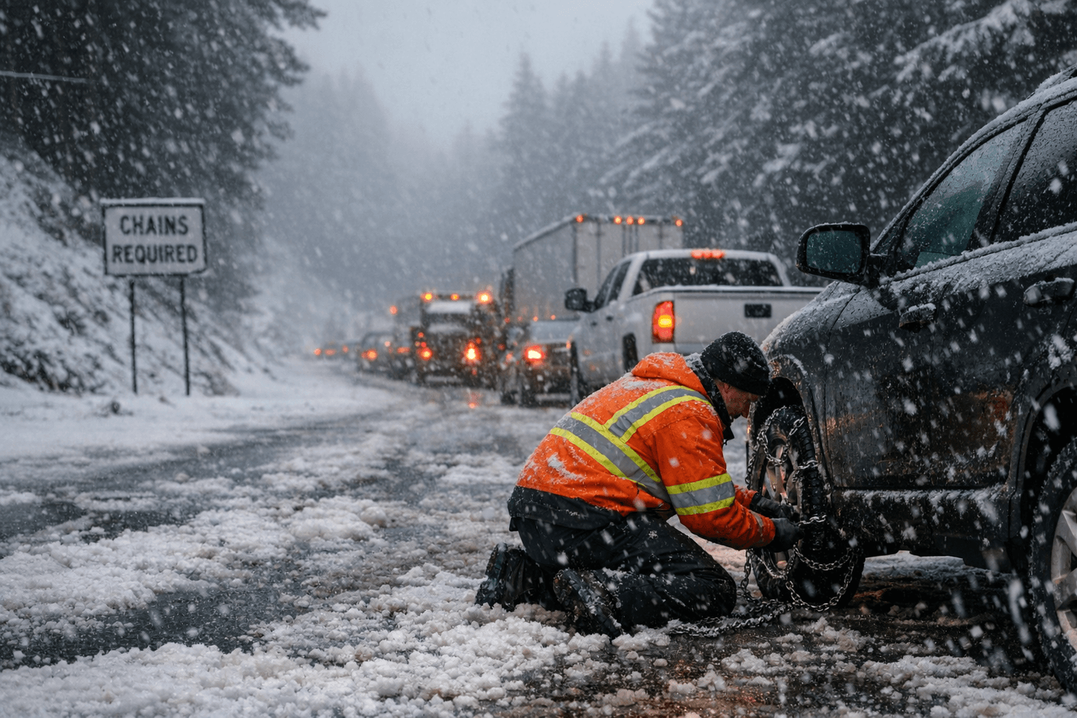
Small hail piled up around Humboldt Bay, making streets slushy and prompting chain controls on CA-299, CA-36 and CA-3 as snow fell as low as 1,500 feet.

Small-diameter hail piled up around Humboldt Bay this morning, creating slushy, slippery road conditions and the look of snow-dappled yards and rooftops as thunder rolled along the Humboldt Coast, NWS meteorologist James White said, calling the event the "first big pulse of an ongoing winter storm."
The National Weather Service in Eureka issued winter-storm messaging warning of heavy wet snow in interior mountain passes and low-elevation snow showers near the coast after snowfall was observed down to 1,500 feet in parts of Humboldt County. Chain controls were activated by Caltrans on state Routes 299, 36 and 3, with chains required as far west as the Lord-Ellis Summit between Blue Lake and Willow Creek, creating delays for drivers heading into higher terrain.
White warned that the disruption was not over, saying that after a "brief reprieve Tuesday evening, a second storm would persist through Thursday and another following closely behind it this weekend." Forecast products accompanying NWS messaging indicated the potential for storms lasting into Thursday to push snow levels even lower, as low as 500 feet and possibly down to the coast, increasing the threat of slushy or icy surfaces on local roads.
Regional forecasts emphasized a colder second storm even if it brings less moisture overall. AccuWeather noted, "Since moisture will be limited with this second storm, widespread heavy rain and mountain snow are not foreseen with it. However, it appears as though it will be a colder storm with lower snow levels that may reach down to intermediate elevations." That pattern could extend problems beyond Humboldt, with low-elevation rain showers and mountain snow forecast from California into Oregon and Washington.
The wider West faces more significant mountain snowfall: AccuWeather projects many Sierra Nevada ski resorts could pick up 3–5 feet of snow into Tuesday, with a general 2–4 feet along Interstate 80 and a high potential for Donner Pass to close for a time from late Sunday night to Monday night. Forecasters also warned of enough snow along I-5 from Northern California into southern Oregon to create slippery travel and raise the risk of road closures, while Southern California faced forecasted localized severe weather risks including damaging wind gusts, hail and isolated tornado or waterspout potential.
Locally, visual evidence of the storm pulse, piled hail around Humboldt Bay and snow on yards and rooftops, underscored immediate hazards for commuters and rural roads. NWS graphic warnings flagged the interior of Humboldt, Del Norte and Trinity counties for potential major impacts, and Caltrans chain controls on CA-299, CA-36 and CA-3 remained the primary on-the-ground mitigation measure for travel into the county’s higher elevations.
This article was produced by Prism’s automated news system from verified source data, official records, and press releases, then run through automated quality and moderation checks before publishing. The system is built and supervised by the people who set the standards it runs under. Read our full AI policy.
Did this article answer your question?