State to Collar Deer and Elk in Humboldt County January 2026
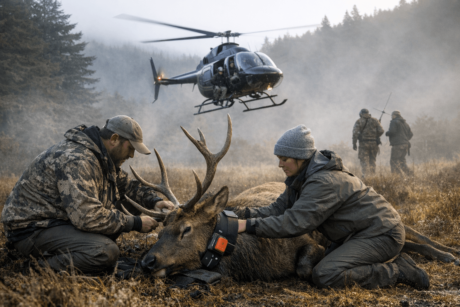
The California Department of Fish and Wildlife announced on December 29, 2025 that helicopter capture and collaring operations will take place in January 2026 and will include portions of Humboldt County. The effort aims to fit GPS collars on mule deer, tule elk and Rocky Mountain elk to improve management knowledge of distribution, habitat use, migration, recruitment and survival, and to share selected wolf location information with livestock producers.

The California Department of Fish and Wildlife announced this week that it will conduct helicopter capture and collaring operations in multiple northern California counties in January 2026, including parts of Humboldt County. Teams will capture and fit GPS collars on mule deer, tule elk and Rocky Mountain elk to collect location data for up to three years. CDFW described the work as part of a statewide effort to refine understanding of distribution, habitat use, migration, recruitment and survival among big game populations.
Separate targeted captures of wolves are planned in Siskiyou, Lassen and Tehama counties and may include additional packs. CDFW said wolf location data will be shared with livestock producers to reduce negative interactions, but the agency clarified that such data will not be provided in real time. Operations will take place on public lands and on private lands when landowner permission has been granted. The agency noted cooperating land managers and referenced its Wolf Tracker mapping tool for situational awareness.
For local residents the operations carry several implications. Helicopter activity may be visible and audible in affected areas during January, which can affect outdoor recreation, livestock handling and daily routines. The multi year collars are intended to provide managers with long term movement data that can inform habitat protections, seasonal access decisions and targeted conflict reduction strategies. The decision to share wolf locations with producers reflects a management emphasis on reducing livestock losses while limiting continuous public dissemination of real time locations.
Institutionally the project highlights CDFW reliance on aerial capture techniques and on partnerships with land managers and private property owners to conduct field research. Data sharing protocols for wolves and big game will shape how managers balance transparency, public safety and producer needs. Residents and landowners who have concerns or who may host operations are advised to contact CDFW for location specific details and permissions as planning continues into January. The collars are expected to transmit for up to three years, providing data that will inform future conservation and land use decisions in Humboldt County.
This article was produced by Prism’s automated news system from verified source data, official records, and press releases, then run through automated quality and moderation checks before publishing. The system is built and supervised by the people who set the standards it runs under. Read our full AI policy.
Did this article answer your question?