Flash Flood Warning Forces Closure of Kūhiō Highway at Hanalei Bridge
Kūhiō (Kuhio) Highway on the Princeville side of the Hanalei River Bridge was closed after Hanalei River waters rapidly rose during heavy rain that fell at 2–3 inches per hour.

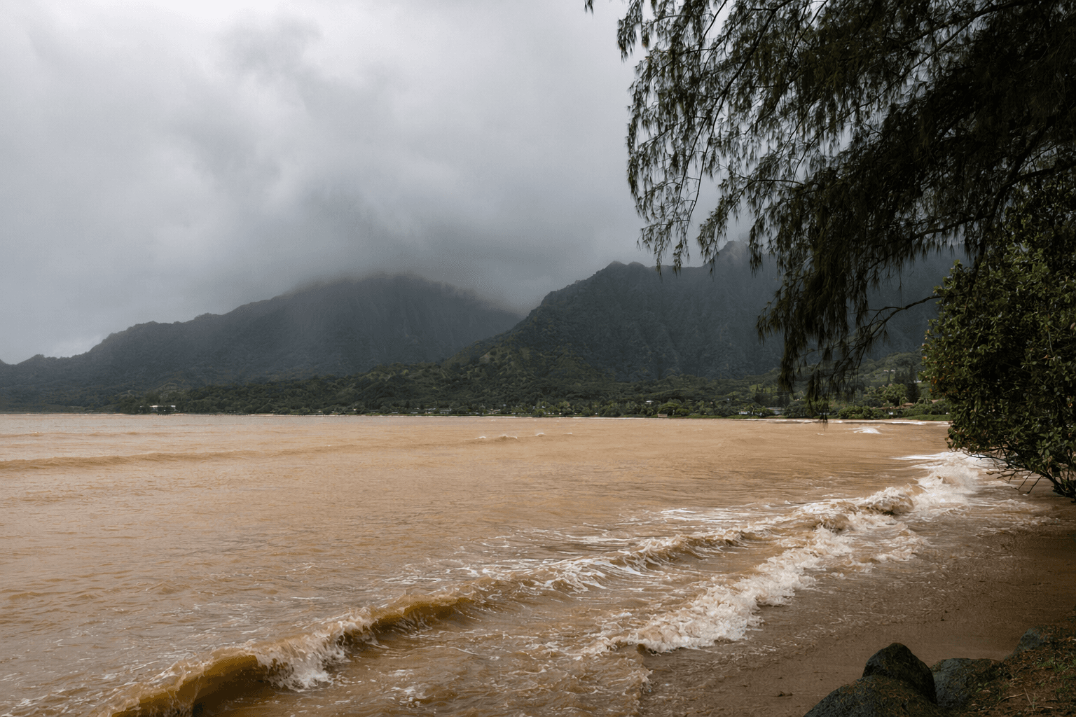
Kūhiō (Kuhio) Highway near the Hanalei River Bridge on the Princeville side was closed early Feb. 21 after heavy overnight rain caused the Hanalei River to rise rapidly, Kauaʻi Emergency Management officials notified residents. Kauaʻi Emergency Management said the highway "will remain closed until further notice because of elevated water levels" and advised motorists that ponding, low visibility and other hazardous driving conditions were expected.
Heavy rainfall began over windward portions of Kaua‘i shortly before 3:00 a.m., and the National Weather Service issued initial flash flood warnings for Kaua‘i and Oʻahu around 3:00 a.m., according to multiple local updates. Kauainownews posted an "Update at 3:28 a.m. Feb. 21, 2026" that "All of Kauaʻi is now under a flash flood warning until 6 a.m. today (Feb. 21) as heavy rain moves over windward sections of the island." Star‑Advertiser radar reporting at 3:49 a.m. said "rain falling at a rate of 2 to 3 inches per hour in the heaviest showers" over windward Kaua‘i as stream levels climbed.
The closure was first reported in near‑real time: Star‑Advertiser noted at 3:49 a.m. that "the Princeville side of Kuhio Highway has been closed near the Hanalei River Bridge due to water over the roadway," and Kauainownews issued a "3:52 a.m. Feb. 21, 2026" update stating "Kauaʻi Emergency Management officials notify the public that Kūhiō Highway near Hanalei Bridge is closed because of flooding." HNN later confirmed the roadway "remains closed until further notice" as flooding persisted.
Warning windows changed through the morning as the system evolved. Kauainownews initially reported the Kauaʻi warning through 6:00 a.m.; HNN posted that as of 8:13 a.m. the Oʻahu warning had been extended until 1:13 p.m. and, as of 8:41 a.m., the flash flood warning for Kauaʻi had been extended until 12:11 p.m. Kauainownews' 9:49 a.m. update said "A flash flood warning in effect for the Garden Island will continue now until noon today" while Wunderground displayed a Flood Watch "Issued: 11:37 AM Feb. 21, 2026 – National Weather Service" and quoted the NWS product warning that "Flash flooding caused by excessive rainfall continues to be possible" through the afternoon.

Impacts reported across the islands matched NWS and local emergency messaging: low‑lying areas, drainage ditches, culverts and flood‑prone roads experienced ponding and closures, and forecasters warned urban areas could see rapid runoff and property impacts. KITV summarized regional conditions: "On Kauai, heavy rain continues across the island. Water levels along the Hanalei River are high enough that Kuhio Highway near the Hanalei River Bridge has been closed. Flooding is affecting low-lying areas, streams, and roads, and additional heavy showers are expected to move onshore this morning." NWS guidance quoted by Star‑Advertiser urged residents "To stay away from streams, rivers, drainage ditches, and culverts, even if they are dry" and warned "Do not cross fast flowing or rising water in your vehicle, or on foot. Turn around, don`t drown."
Meteorologists traced the event to an upper‑level trough swinging through the northwestern islands after an end to an extended period of strong trade winds, with moisture colliding over the state. Kauainownews summarized forecaster guidance from Feb. 20: "the extended period of strong trade winds the state had been experience would come to an end that night, ushering in chances for heavy rain and thunderstorms, fueled by moisture moving east and west over the state meeting an upper level trough swinging through the northwestern islands." Wunderground reproduced NWS product language that the trough "should lift north of the area later this afternoon, which should diminish the flooding threat," and multiple outlets said the flood risk is expected to lessen by Sunday, Feb. 22.
Local monitoring stations appeared on weather displays throughout the morning; Wunderground showed a Lihue station block with elevation 197 ft and coordinates 21.98 °N, 159.37 °W, and a Nawiliwili Ahupua`a Station report listing 71 °F. Kauaʻi Emergency Management reiterated that the public "is advised to stay tuned to local media for updates on road closures" as officials track river levels and determine when Kūhiō (Kuhio) Highway can safely reopen.
Know something we missed? Have a correction or additional information?
Submit a Tip