How Kootenai County protects its sole-source drinking water aquifer
Kootenai County’s taps, growth patterns and spill risks all depend on the hidden Spokane Valley-Rathdrum Prairie Aquifer, making water protection a daily land-use choice.
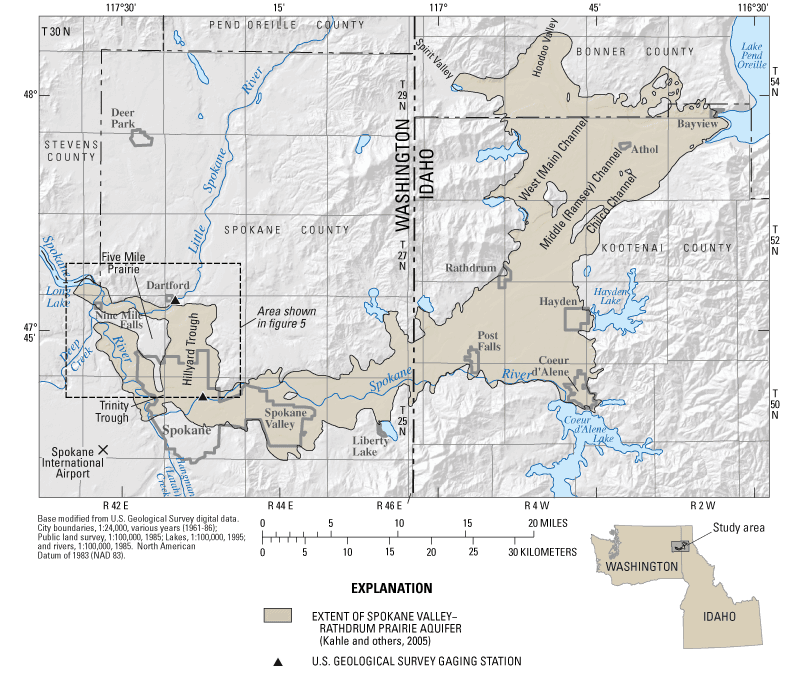
The Spokane Valley-Rathdrum Prairie Aquifer spans about 370 square miles in northern Idaho and eastern Washington, and its coarse Ice Age gravels move water fast enough to supply a large region while also allowing pollution to spread quickly if it is not controlled. The water under the Rathdrum Prairie keeps faucets running in Kootenai County, which is why every subdivision, storm drain and spill response matters.
What makes the aquifer different
The aquifer is built from flood-deposited gravels, cobbles and boulders left behind by Ice Age events, a structure that gives it both strength and risk. Water can move efficiently through those materials, which is why the system can yield clean groundwater for homes and businesses, but it also means contamination does not stay put for long. A 2007 U.S. Geological Survey study found the aquifer extends through Spokane County, Washington, and Bonner and Kootenai counties in Idaho, making it a shared bi-state resource rather than a county-by-county supply.
That shared geography reaches Coeur d'Alene, Hayden, Post Falls and the county’s unincorporated areas through the same drinking-water system. When groundwater quality is protected, residents get reliable drinking water from the same hidden system that supports schools, restaurants, shops and construction projects. When it is stressed, the consequences can show up in household taps, business operations and the cost of developing new land.
Why sole-source status matters at the tap
The U.S. Environmental Protection Agency has designated the aquifer a sole-source aquifer, which means it is the only affordable drinking-water source for the bi-state region it serves. The aquifer received that designation in 1978, one of the first in the nation, a 2004 Spokane Aquifer Joint Board case study found. It supplies drinking water for more than 500,000 people every day, and a 2003 Idaho Department of Water Resources project scope identified it as the sole source of drinking water for more than 400,000 residents in Spokane County, Washington, and Kootenai County, Idaho.
For Kootenai County, that status changes the meaning of growth. A new industrial site, a dense housing development or a poorly managed spill is not only a zoning issue or an environmental concern. It is a potential drinking-water issue for families, employers and public facilities that depend on the aquifer beneath them.
How protection happens before water reaches a faucet
The aquifer has been studied in considerable detail since 1977, and that long paper trail is part of how local protection works. Idaho designated it a “Sensitive Resource Aquifer” in its state Ground Water Quality Rule, and Spokane County and Panhandle Health District initiated a Ground Water Monitoring Program for the aquifer. Wellhead protection planning was updated in 2007, after four years of U.S. Geological Survey bi-state aquifer study, and monitoring results were presented to the public in the 2000s.
Local governments use aquifer protection boards, development review and education for property owners to manage stormwater controls, spill response, septic maintenance and wellhead protection.
A few of the pressure points are easy to see:
- development on recharge areas, where rainfall and snowmelt can move into the aquifer quickly
- spills on roads, lots and job sites, where surface pollution can seep downward fast
- septic and wastewater issues in growing neighborhoods
- stormwater runoff from roofs, pavement and disturbed ground
Growth makes protection harder to ignore
The Idaho Water Resources Research Institute puts county population at 35,332 in 1970, 183,578 in 2022 and more than 319,000 by 2045. That kind of growth means more rooftops, more pavement, more businesses and more pressure on the same underground water system that already serves a large share of the region.
It is one of the limiting factors that decides where growth can happen safely, how dense it can be and what kind of infrastructure must come with it. In practice, that affects where stormwater is handled, how spills are contained, how wells are protected and how much attention local officials pay to land-use decisions in Post Falls, Hayden, Coeur d'Alene and the county’s outlying areas.
Why the Spokane River is part of the same system
The Spokane River is hydrologically connected to the Spokane Valley-Rathdrum Prairie Aquifer, and some river reaches receive water from the aquifer. That means groundwater decisions do not stop at the edge of a well field, because water moving below ground can influence surface water flow and water quality above it.
The same broader water system that supports homes and businesses also shapes the river environment that people use for boating, fishing and shoreline life.
How the region pays for protection and plans ahead
The original SVRP Aquifer Atlas was published in 2000 and updated in 2004, 2009 and 2015, with a fifth edition being prepared in 2023.
Spokane County’s voter-approved Aquifer Protection Area fee funds groundwater monitoring projects and protection initiatives. In Kootenai County, the Aquifer Protection District Advisory Board produced a master plan called “OUR GEM.”
This article was produced by Prism’s automated news system from verified source data, official records, and press releases, then run through automated quality and moderation checks before publishing. The system is built and supervised by the people who set the standards it runs under. Read our full AI policy.
Did this article answer your question?