North Idaho snowpack concerns raise wildfire worries across Kootenai County
Low snowpack in North Idaho could mean faster fire spread, smokier summers and more pressure on water and power planning across Kootenai County.
Low snowpack in North Idaho is already shaping the summer risk picture for Kootenai County homeowners, insurers and recreation businesses, with state and utility officials warning that less snow storage can mean drier fuels, tighter water supplies and more wildfire pressure later in the season.
That warning was laid out before about 100 people at the Hagadone Event Center during the Coeur d’Alene Chamber Regional Chamber’s Breakfast Connect, where Isabel Davis of the Idaho Panhandle Avalanche Center said the region has been dealing with troubling snowpack data, heavy rainfall and atmospheric river patterns that carried over from late 2025 into the new year. Even where the mountains saw feet of snow, much of it has been washed away by rain, leaving less reliable water storage heading into fire season.
The Natural Resources Conservation Service says snowpack is a critical input for spring and summer runoff forecasting, and that those forecasts affect municipal and industrial water supply, flood control, recreation, power generation and water quality management. NRCS publishes its Water Supply Outlook Reports monthly from January through June, putting North Idaho squarely in the middle of the key monitoring window for runoff and fire planning.
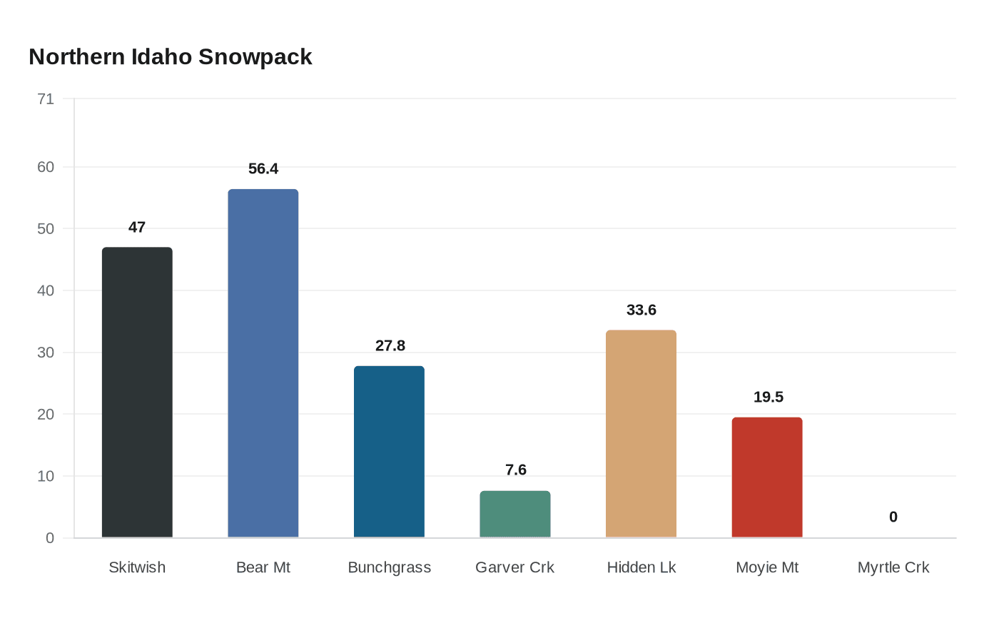
In its March 1 report, NRCS said Northern Idaho basins had both below-normal snowpack and below-normal precipitation. The agency described Idaho as being in a warm snow drought, meaning mild temperatures often pushed precipitation to fall as rain instead of snow. Skitwish Ridge measured 47% of normal on March 1, with 12 inches of snow water equivalent compared with a period-of-record median of 26.8 inches.
The numbers stayed weak into April. An April 17 Idaho SNOTEL update showed several Northern Panhandle sites still below median, including Bear Mountain at 56.4% of median current SWE, Bunchgrass Meadow at 27.8%, Garver Creek at 7.6%, Hidden Lake at 33.6%, Moyie Mountain at 19.5% and Myrtle Creek at 0.0%.
Davis also said January started strong before a 16-day dry stretch, and February brought the winter’s most significant period of natural and human-triggered avalanches. That pattern matters beyond the backcountry. The same weather conditions that drive avalanche danger can also signal broader water and fire concerns across the county, where summer smoke, evacuation readiness and insurance risk can all rise when the winter snowpack underperforms.
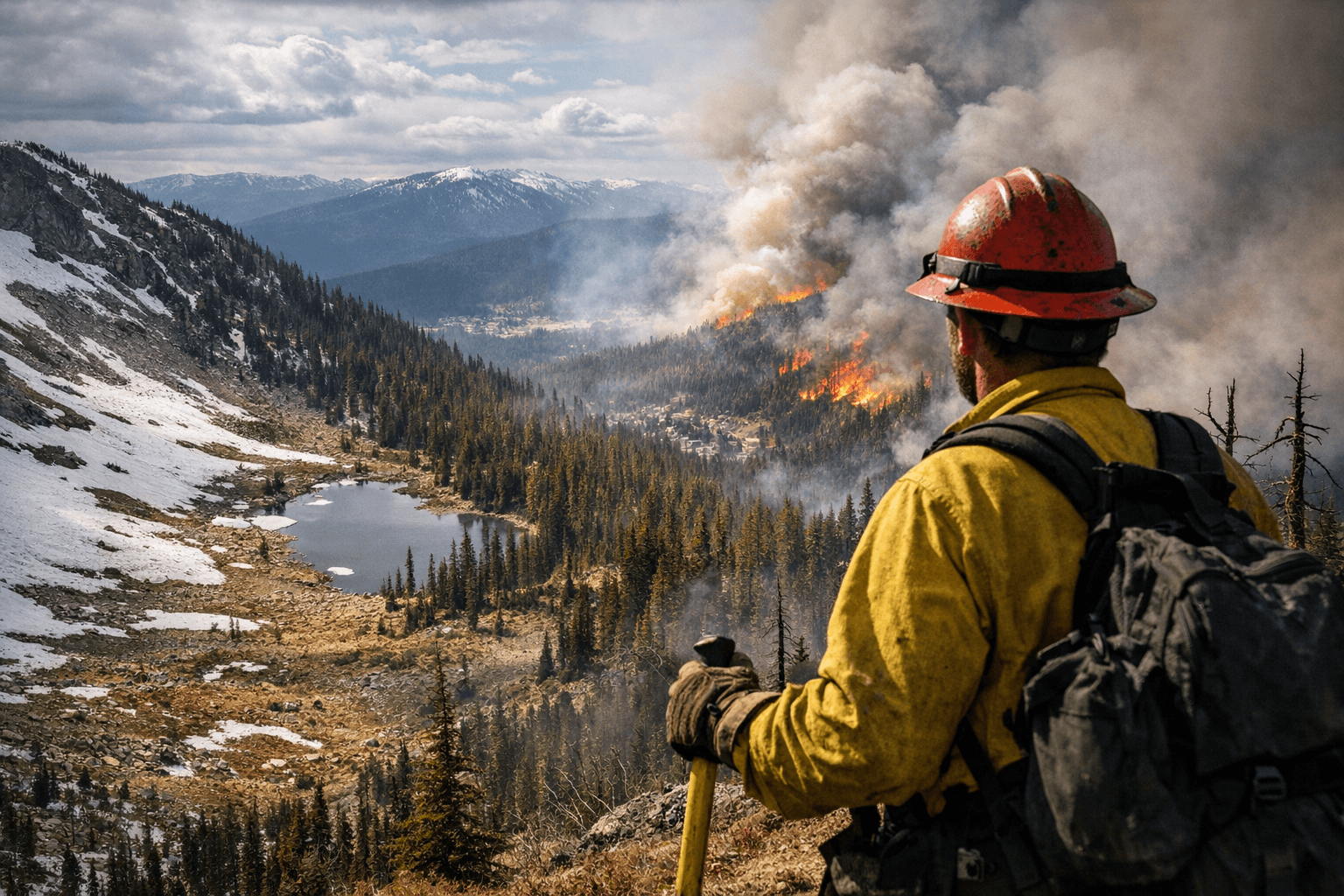
Todd Kiesbuy of Avista added a utility view, saying fires today are burning hotter and faster. He said the company has been hardening its grid and burying power lines where possible, and that its public safety power shutoff protocol is a last resort used only after multi-day monitoring.
The concern comes as Kootenai County is already back in formal mitigation planning. The Coeur d’Alene City Council was considering the 2026 Kootenai County Multi-Jurisdictional All-Hazard Mitigation Plan, a review that happens every five years and was last done in 2020. The county also has recent wildfire experience, including the 2025 fire on Canfield Mountain that Idaho Department of Lands crews fully contained. With snowpack still running low and spring turning quickly toward summer, the stakes now reach well beyond the mountains.
This article was produced by Prism’s automated news system from verified source data, official records, and press releases, then run through automated quality and moderation checks before publishing. The system is built and supervised by the people who set the standards it runs under. Read our full AI policy.
Know something we missed? Have a correction or additional information?
Submit a Tip