La Paz County explains how to trace deeds, liens and parcel history
La Paz County splits property research across three offices. Here is where to look for deeds, liens, parcel maps and tax-deeded listings before you buy land.
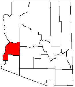
A deed trail in La Paz County runs through the Recorder’s Office, a tax question goes to the Treasurer, and a parcel boundary issue often ends up on the county GIS page. In a county with riverfront lots, desert tracts and parcels where the legal description matters more than a street number, that distinction can decide whether a purchase or estate transfer goes smoothly.
Start with the recorder when the question is ownership or a lien
If you need the paper trail, the county Recorder’s Office is the first stop. The office is responsible for recording and maintaining all documents presented for public record. For La Paz County, that matters because deeds, liens and other recorded instruments are not all sitting in one general property portal.
The practical search path is straightforward: use the county’s recorded-document search instructions, choose Arizona and La Paz, and search by name, business name or legal description. That last option is especially useful in a rural county where a parcel may be identified more reliably by section, township and range than by a mailbox address. The Recorder’s Office is at 1108 Joshua Avenue in Parker, with phone number 928-669-6115.
When a neighbor dispute, an inheritance question or a title issue turns on “who recorded what, and when,” the recorder is the office that can show the document itself.
Use the assessor for parcel identity, value and map context
The Assessor’s office is where parcel research becomes more visual and more technical. La Paz County’s online property records search is EagleWeb. Its stated vision is to ensure all properties in the county are valued fairly and equitably. The office is at 1112 Joshua Ave., Suite 204, Parker, and the main phone number is 928-669-6165. Office hours run Monday through Thursday from 7:00 a.m. to 6:00 p.m.
For parcel history, the assessor’s records help connect ownership references to the county’s appraisal side of the file. That is the right place to confirm how the county is identifying the parcel, what value is attached to it, and whether the record lines up with the legal description you found in the recorder’s system. In a county with incorporated towns such as Parker and Quartzsite as well as river and desert property, the description on paper may be more accurate than the informal way neighbors refer to a lot.
The assessor’s parcel-map materials have also moved online. The county no longer maintains plat books in physical form and directs users to the county GIS page for assessor records and maps. If you are holding a paper plat book expectation, La Paz County no longer treats that as the official route. The GIS page is the current reference, and if a map, boundary line or parcel shape is not clear there, the county’s process points you back to the office rather than to a shelf of bound maps.
Check the treasurer when the question is tax status or payment history
The Treasurer’s office answers the tax side of the story. La Paz County’s parcel search and online payment page is where residents check the tax status connected to a parcel, make payments and handle tax-related questions that do not belong in the recorder’s document file or the assessor’s valuation record. The office is also at 1112 Joshua Ave., #203 in Parker, with phone number 928-669-6145 and fax number 928-669-5393. Its hours are Monday through Thursday from 7:00 a.m. to 6:00 p.m.
A recorded deed can tell you who transferred a parcel; the treasurer’s system tells you whether taxes are current or whether a parcel has moved into a tax problem that may affect a future sale.
The treasurer’s page also supports online payment. If you are trying to avoid a delinquency problem or confirm whether a payment has posted, this is the office to use, not the recorder and not the assessor.
Use the GIS page when the boundary line is the real issue
For parcel boundaries, the county’s GIS resources are the cleanest follow-up once you have the parcel number or legal description. The Assessor’s office no longer keeps plat books in physical form, and all assessor records and maps can be found through the county GIS page. That is the practical answer when a buyer, executor or adjoining landowner needs to see where a parcel sits in relation to roads, waterways or neighboring tracts.
Residents now verify shape, acreage and placement through GIS, especially in a county where parcels may sit along the Colorado River or spread across open desert. If the map on one system does not line up with what a deed suggests, the county’s own workflow suggests the next step is to verify it through the assessor or recorder rather than relying on an old paper plat book.
Tax-deeded property has its own rules
La Paz County keeps tax-deeded property separate from ordinary parcel browsing, and that separation is important for anyone looking at a bargain lot or settling an estate with tax problems. La Paz County will accept offers on tax-deeded properties after a bid sale. The page also points interested parties to the county’s process, forms and contact information.
A tax-deeded parcel sits in a special category with its own rules, and anyone interested in buying such property needs to follow county procedure rather than assuming a private transaction works the same way.
This article was produced by Prism’s automated news system from verified source data, official records, and press releases, then run through automated quality and moderation checks before publishing. The system is built and supervised by the people who set the standards it runs under. Read our full AI policy.
Did this article answer your question?