Poston War Relocation Center, Once Home to 17,800 Japanese Americans, Stands Near Parker
A working sundial monument on Mohave Road marks where 17,867 Japanese Americans were imprisoned on tribal land that the Colorado River Indian Tribes explicitly fought to protect.
Three miles separate each of the camps that once held more people than Parker holds today. The Poston War Relocation Center, located 12 miles south of Parker along what is now Mohave Road, was the largest Japanese American incarceration site in the United States by area, covering roughly 71,000 acres of the Colorado River Indian Reservation in what was then Yuma County and is now La Paz County. Its population peaked at 17,867, the majority of them U.S. citizens, making Poston not merely a footnote in national history but the most consequential event ever to occur on this stretch of western Arizona desert.
A forced removal, built on someone else's land
In the summer of 1942, scant months after the Japanese attack on Pearl Harbor, almost 18,000 Japanese Americans from California, Oregon, and Washington were shipped to what was euphemistically called a "relocation center." The legal authority came from Executive Order 9066, signed by President Franklin D. Roosevelt on February 19, 1942. The camp was built by contractor Del Webb using thousands of workers, and it was constructed on Colorado River Indian Reservation land despite objections by the tribal council, who did not want any part of the center.
Poston was built on the Colorado River Indian Reservation over the objections of the Tribal Council, who refused to be part of doing to others what had been done to their tribe. Army commanders and officials of the Bureau of Indian Affairs overruled the council, seeing the opportunity to improve infrastructure and agricultural development on the War Department budget. The irrigation system internees helped build during their imprisonment remains in use in the surrounding community today.
Three camps, one shared ordeal
The site was composed of three separate camps arranged in a chain from north to south, three miles from each other. Internees named the camps Roasten, Toastin, and Dustin, based on their desert locations. Those dark nicknames captured a real physical reality: temperature extremes were common in the desert, with highs reaching 115°F and lows down to 35°F. Dust was a constant problem. The three units together opened in May and June of 1942 and did not close until November 28, 1945.
Poston was a War Relocation Authority concentration camp located in southwestern Arizona near the town of Parker, close to the border with California. The most populous camp until Tule Lake was turned into a segregation facility, Poston was located on an Indian reservation and, until 1943, was jointly operated with the Office of Indian Affairs. The "Poston Strike" of November 1942 was one of the largest and most successful acts of resistance to WRA control, ending in a negotiated settlement that gave the strikers much of what they had demanded. That strike, triggered by the arrest of two men accused of beating an alleged informer, became one of only two major public confrontations in all ten WRA camps and reshaped the authority's policies for years afterward.
The memorial monument
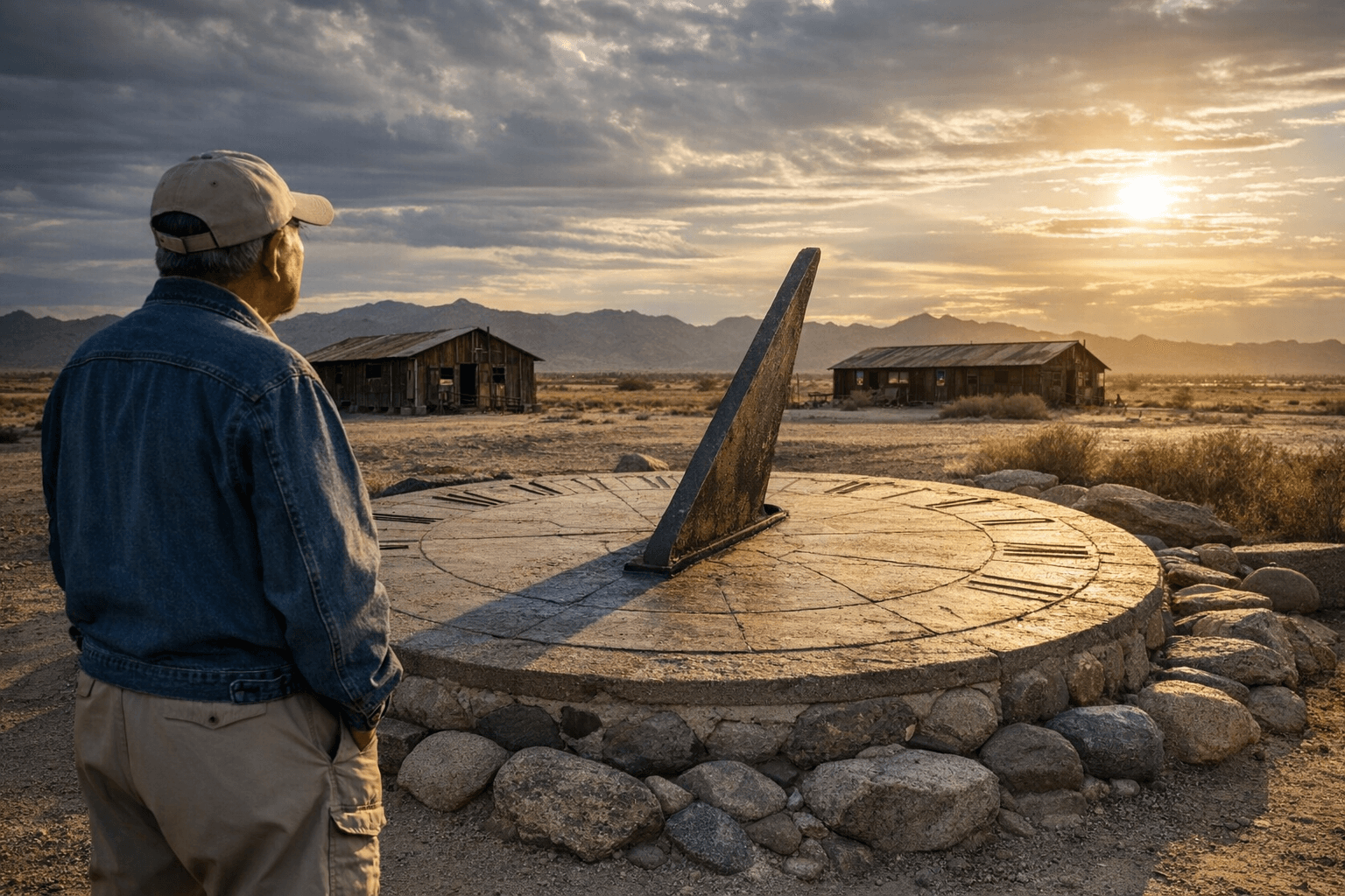
The Poston Memorial Monument marks the site where 17,867 persons of Japanese ancestry, the majority of whom were United States citizens, were interned during World War II from May 1942 to November 1945. The Poston Memorial Monument was built near the site in 1992. More specifically, it was dedicated on October 6, 1992, conceived three years earlier and financed entirely through donations from survivors and their descendants.
The single 30-foot concrete pillar of the monument symbolizes "unity of spirit." The hexagonal base represents a Japanese stone lantern. The 12 small pillars situated around the monument make it a working sundial. Mounted on the pillar base are six plaques; a nearby kiosk carries four additional plaques. The monument's designers, Ray Takata and Stephan Hamamoto, say that the Colorado River Indian Tribal Council granted use of one acre of land on which the monument and kiosk are built. The tribe that once objected to the camp's very existence now stewards the ground where its memory is kept.
Getting there: precise directions
The monument's street address is 23701 Mohave Road, Parker, AZ 85344, and its GPS coordinates are 33° 59.258′ N, 114° 24.073′ W. It is on Mohave Road, 11.7 miles south of Arizona Route 95. From Parker, head south on Arizona Route 95, then turn onto Mohave Road; the pillar is visible from the road on your right when traveling north.
If you are approaching from Interstate 10, take the Ehrenberg exit, then travel Ehrenberg Road in an easterly direction until it turns north towards Parker. The monument is accessible by standard passenger vehicle and offers easy roadside parking.
What to expect on site
Both sides of the main road to the camp are mainly farms owned by tribal members; you should not trespass or wander off the highway without permission. The monument itself sits on that one granted acre of tribal land and can be visited respectfully at any time. Plan to spend 20 to 40 minutes reading all the plaques carefully; visitors who rush past the kiosk miss the photographs and community context that give the pillar its full weight.
The Poston Elementary School at Unit I is a National Historic Landmark, and remnants of foundations and slabs remain at all three camp units for those who want to locate the broader footprint. Come prepared: there is no indoor visitor center or shaded seating at the monument itself. When visiting in summer, temperatures can reach 110°F, so bring a hat and sunscreen. Water is essential. The CRIT Museum in Parker, located near the Safeway on the main commercial strip, maintains a dedicated display on the camp with photographs and historical background and is worth pairing with a monument visit, especially during extreme heat.
What most people don't know
The single most overlooked fact about Poston is that the Colorado River Indian Tribes formally and explicitly refused to allow the camp on their land before construction began. The Colorado River Indian Tribes Tribal Council objected, refusing to take part in what they saw as a grave injustice against another displaced people. Their protests were ultimately overruled by the Office of Indian Affairs and the U.S. Army, and construction proceeded. That refusal is documented and morally significant: this land's Indigenous stewards recognized the injustice clearly, said so on the record, and were ignored. Their eventual decision to donate the acre for the 1992 memorial is one of the more quietly powerful acts of reconciliation in Arizona history.
For a map reference: the monument sits just off Mohave Road, the same road that bisects the former camp footprint and connects Poston to Parker 15 miles to the north and Ehrenberg 28 miles to the south. The three camp units ran along this corridor in sequence.
For primary sources, three archives are essential:
- Poston Preservation (postonpreservation.org) holds oral histories, photographs, and monument documentation assembled by survivors and descendants.
- The Densho Encyclopedia provides the most thorough scholarly overview of the camp's administration, population demographics, and the 1942 strike.
- The Arizona Memory Project, maintained by the Arizona State Library, holds digitized photographs and documents from the 1942 to 1945 period, including materials from the camp's three-unit layout.
An annual Poston Pilgrimage brings survivors, descendants, and community members back to the monument each year, making it one of the few living connections between today's La Paz County residents and the 17,867 people who endured three and a half years in the Sonoran desert because of who they were. That pilgrimage continues because the history it marks has not finished speaking.
This article was produced by Prism’s automated news system from verified source data, official records, and press releases, then run through automated quality and moderation checks before publishing. The system is built and supervised by the people who set the standards it runs under. Read our full AI policy.
Did this article answer your question?