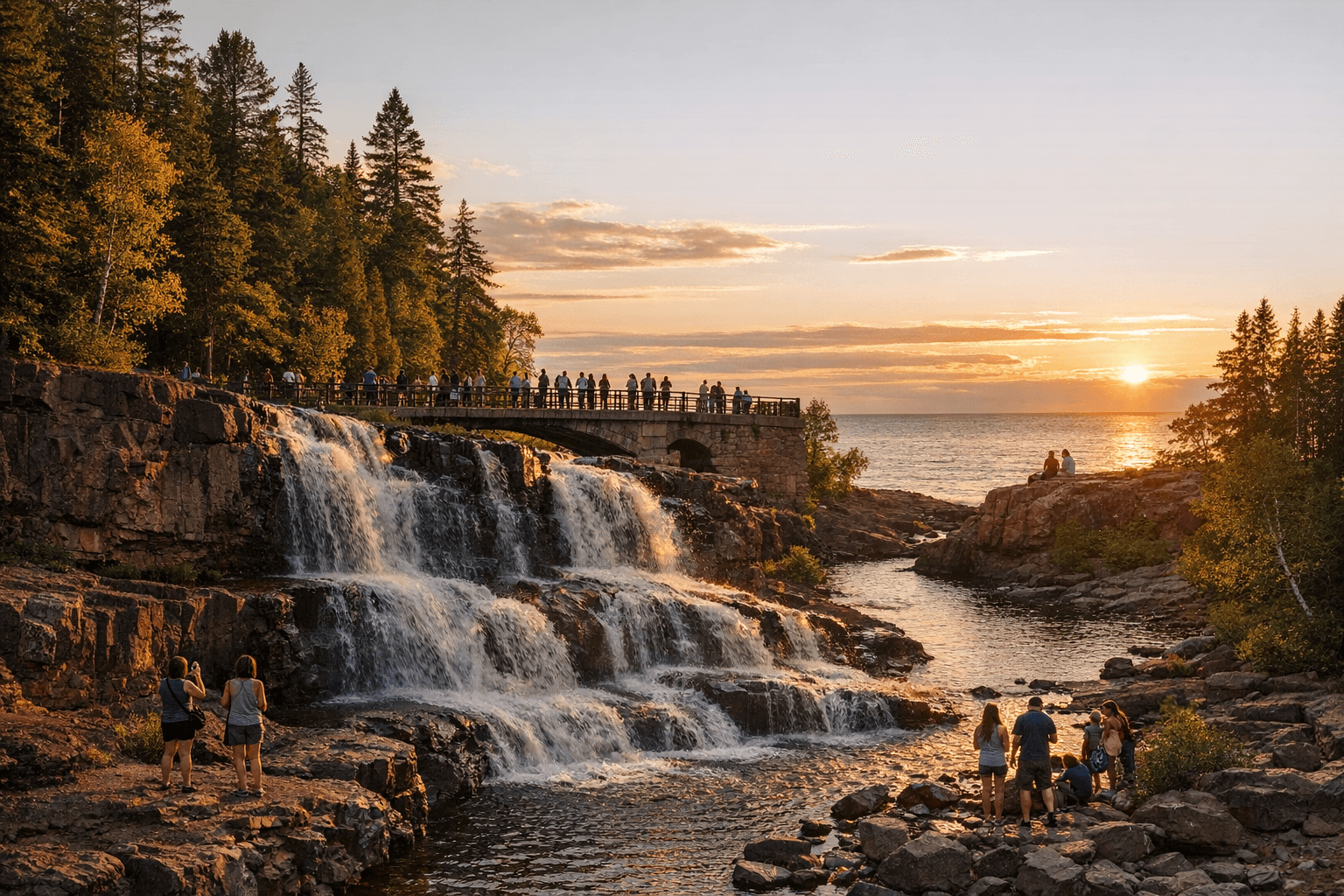
Gooseberry Falls State Park draws visitors with waterfalls and Lake Superior views
Gooseberry Falls is more than a scenic stop. Its easy access, heavy traffic, and trail links make it a major driver of local activity in Lake County.
Why Gooseberry Falls keeps pulling people to Lake County
Gooseberry Falls State Park has become one of Lake County’s most visible public assets because it offers something rare on the North Shore: iconic scenery with easy access. The park’s waterfalls, Lake Superior overlooks, picnic areas, and hiking trails bring in families, photographers, anglers, and day-trippers who can experience the shoreline without a long backcountry commitment. The Minnesota Department of Natural Resources calls it the “gateway to the North Shore,” and that role is still visible in the flow of cars, trail users, and visitors who turn a waterfall stop into a day-long outing.
That steady draw matters well beyond the park boundary. Gooseberry Falls helps anchor the visitor economy in nearby places such as Two Harbors, Silver Bay, and Beaver Bay, where stops for food, fuel, supplies, and lodging often follow a visit to the falls. In a region where seasonal swings can shape staffing and revenue, the park’s dependable foot traffic gives local businesses a reliable stream of customers and keeps pressure on roads, parking areas, trails, and public facilities.
A park built for access, not just scenery
Part of Gooseberry Falls’ appeal is how easy it is to visit. The park is open daily from 8 a.m. until 10 p.m., and the Nature Store/Visitor Center is open daily from 10 a.m. to 4 p.m. No vehicle permit is required to park in the wayside and visitor center lot, which removes one more barrier for casual visitors and makes the park especially convenient for short stops along the shore.
That access is backed by a full set of visitor facilities. The visitor center includes a theater, interpretive displays, a trail center, a nature store, modern bathrooms, vending machines, park offices, and travel information. The displays cover geology, history, plants, animals, watersheds, and the Civilian Conservation Corps, which gives the park a stronger educational function than many roadside attractions. It is not just a place to look at waterfalls; it is a place to understand the North Shore.
Why the park matters to the local economy
Gooseberry Falls is one of those places where natural beauty becomes economic infrastructure. Visitors who come for the falls often continue on to nearby businesses, and the park’s popularity makes it a recurring factor in conversations about traffic, parking, and trail crowding. That is especially important in a county where tourism and outdoor recreation are major parts of the local economy and where a single well-known site can shape spending patterns across a wide area.
The park map notes that parking at the visitor center lots is limited because of frequent high traffic, and it warns that parking longer than two hours is not always available there. That creates a practical challenge for visitors and a planning issue for the county and state alike. High demand can boost business nearby, but it also means congestion at peak times and more wear on public infrastructure, from lots and trailheads to restrooms and access roads.
Trails, shoreline access, and regional connections
Gooseberry Falls is also a transportation link of a different kind. The park includes a 2.5-mile paved segment of the Gitchi-Gami State Trail that connects to Silver Bay, and the DNR says the continuous paved trail runs from Gooseberry to Silver Bay. The park map also shows the trail continuing west toward Beaver Bay and Split Rock Lighthouse State Park. That makes Gooseberry part of a larger corridor for walking and biking along the Lake Superior shoreline, not just a stand-alone destination.
The trails wind through about 1,700 acres of mixed evergreen, aspen, and birch forest bordering Lake Superior. Explore Minnesota says the park offers 20 miles of hiking trails, 12 miles of cross-country ski trails, and 2 miles of snowmobile trails. The DNR says year-round naturalist programs also help extend the park’s value beyond summer tourism. Together, those features keep Gooseberry active in every season and deepen its role as a public space for both recreation and learning.
A landscape shaped by lava, glaciers, and water
The park’s scenery is striking because the geology is dramatic. The basalt at Gooseberry Falls formed from volcanic lava about 1.1 billion years ago, and the park map says the Upper, Middle, and Lower Falls are formed by three lava flows. The Minnesota Historical Society notes that glaciers, wind, water, and lava shaped the cliffs and the Lake Superior basin, giving the park the rugged structure that visitors see today.
That geology is not just scenic background. It helps explain why the falls exist where they do, why the river gorge is so distinctive, and why the shoreline is both beautiful and fragile. The park’s interpretive materials turn that deep history into something visitors can see and understand, which is part of what makes Gooseberry so effective as a public destination.
History that still defines the park
Gooseberry Falls State Park was authorized for preservation in 1933, and Civilian Conservation Corps workers built nearly all of the park’s buildings between 1934 and 1941. The Minnesota Historical Society says Gooseberry was the first of eight state parks developed along Lake Superior’s North Shore, which makes it a foundational site in the region’s conservation history. The park’s log and stone structures still reflect that era and remain part of the landscape visitors experience today.
MNopedia also places the park in the broader rise of North Shore tourism. It notes that tourism expanded in the 1910s and 1920s, and that state highway rerouting in 1925 helped bring more visitors by improving access along the shore. Earlier travel patterns had often bypassed the Gooseberry River, while logging shaped the area in the late 1800s. The park that exists now is the result of those layered changes: industrial use, conservation policy, highway access, and the growth of tourism all left their mark.
Safety, seasons, and stewardship
The DNR and park map also make clear that Gooseberry’s popularity comes with real safety concerns. Slippery rocks, cliffs, and strong currents are recurring hazards, and visitors are told to stay on trails and respect the shoreline conditions. The DNR also says the park is not open for winter fat-tire biking, though hiking, skiing, camping, and naturalist programming remain part of the year-round mix.
That stewardship balance is one of the park’s most important functions. The challenge is to keep the site open and usable while protecting the waterfalls, gorge, and shoreline that make it worth visiting in the first place. Gooseberry Falls succeeds because it combines all of those roles at once: a scenic stop, an outdoor classroom, a tourist magnet, and a lasting piece of Lake County’s public infrastructure.
This article was produced by Prism’s automated news system from verified source data, official records, and press releases, then run through automated quality and moderation checks before publishing. The system is built and supervised by the people who set the standards it runs under. Read our full AI policy.
Did this article answer your question?