Two Storm Systems to Bring Heavy Snow, Freezing Rain to Northland
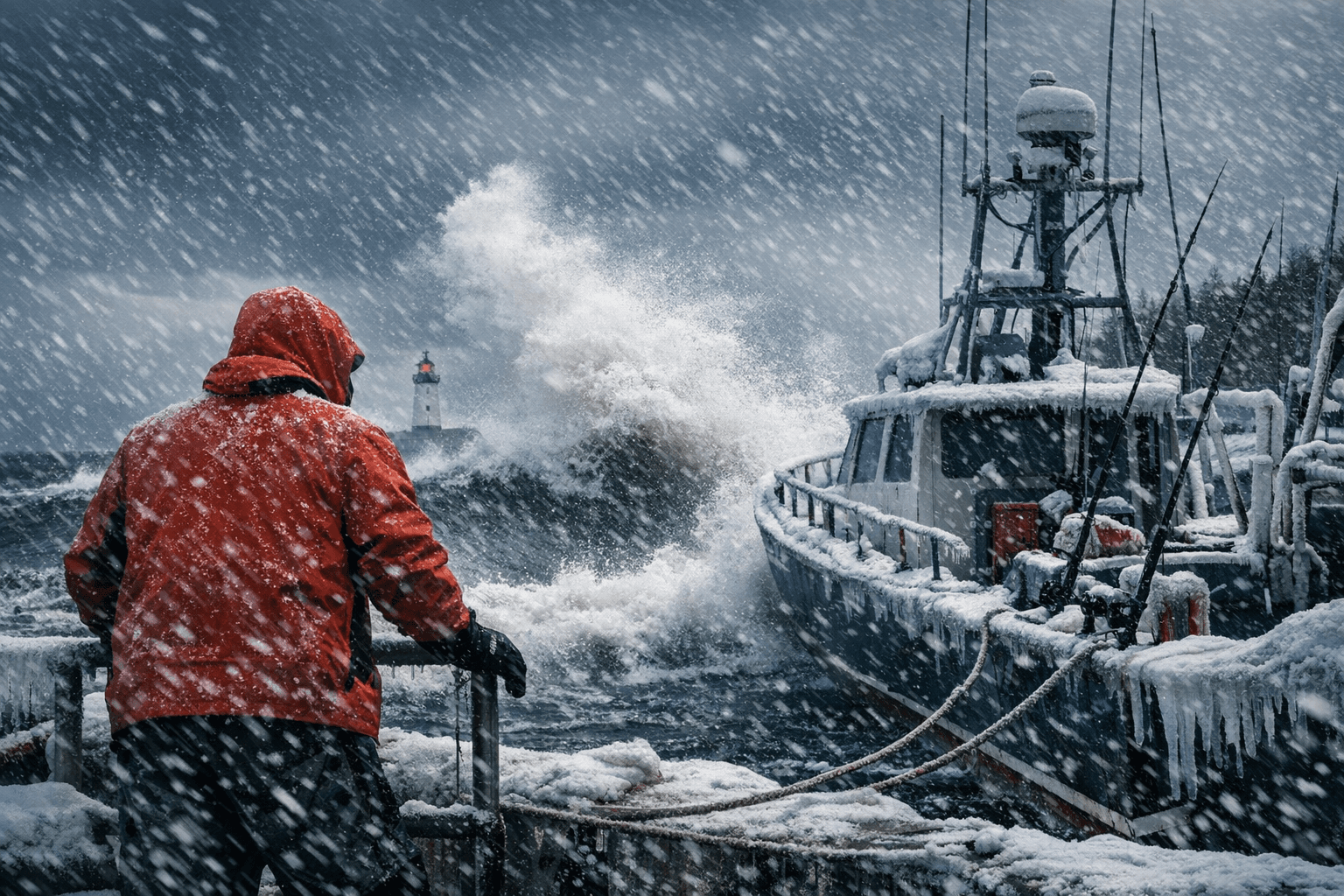
Waves hit 20 feet on Lake Superior and winds topped 50 mph as two April storms buried Lake and Cook counties under up to 11 inches of wet snow, grounding charter fleets for days.
Waves cresting at 20 feet on Lake Superior's open water and northeast winds gusting past 50 mph forced charter operators from Two Harbors to Grand Marais off the water for days as back-to-back storms delivered the North Shore's heaviest April precipitation sequence in years.
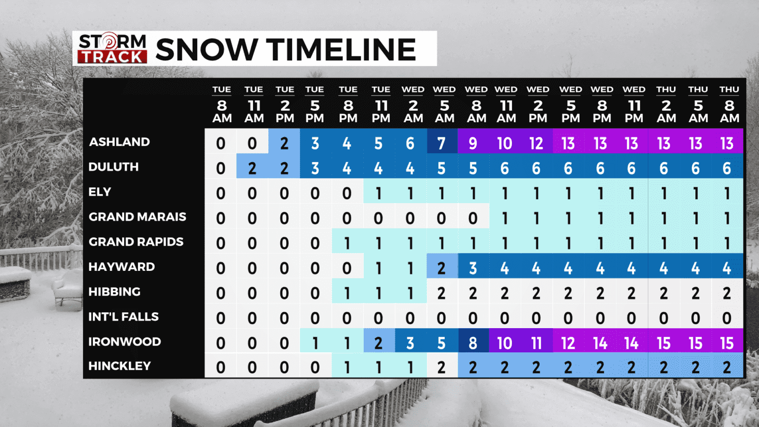
The National Weather Service in Duluth tracked two separate winter systems through the Northland beginning the night of April 1. The first moved through Wednesday night into early Friday morning, dropping 6 to 9 inches across Cook County's Winter Storm Warning zone and 5 to 7 inches across lower-elevation portions of Lake County under the advisory. Snowfall rates peaked at a quarter to a half inch per hour through Thursday. Temperatures hovering near freezing kept snow from bonding firmly to Highway 61 pavement for much of Thursday, but accumulation still mounted on shoulders and uncleared surfaces through the storm period.
A Gale Warning covered Lake Superior throughout both systems. With waves reaching 20 feet in open water and winds gusting above 50 mph along the North Shore, harbor areas from Silver Bay to Grand Portage faced conditions that made any small-craft movement dangerous. The early-April stretch typically marks the start of the spring charter fishing ramp-up, and the sustained gale warning wiped out multiple operating days for commercial and recreational operators alike. High waves battered shoreline stretches on unprotected sections of the lakefront corridor where storms made direct landfall.
Storm 2 activated at 4 p.m. Friday, April 3, with a new Winter Storm Warning covering both Lake and Cook counties, running through 1 a.m. Sunday. NWS Duluth described that system's snow as "likely to be wet and heavy," with total accumulations ranging from 4 to 11 inches across the two-county area. Gusty winds of 20 to 40 mph added blowing snow and stretches of reduced visibility on exposed sections of Highway 61.
The freezing-rain threat fell primarily south of Lake County. The I-35 corridor and parts of northwest Wisconsin accumulated 0.1 to 0.25 inches of ice on roads and power lines, creating a different hazard than the snow load farther up the Shore. Drivers connecting the North Shore to the Twin Cities navigated a shifting precipitation picture as elevation dropped south of Duluth.
Local schedules absorbed disruptions beyond the roads. The Cook County Highway Department rescheduled a community biochar demonstration, originally planned during the storm window, to April 9. For real-time road conditions, NWS Duluth directed travelers to 511mn.org, with current watches and warnings posted at weather.gov/dlh.
This article was produced by Prism’s automated news system from verified source data, official records, and press releases, then run through automated quality and moderation checks before publishing. The system is built and supervised by the people who set the standards it runs under. Read our full AI policy.
Did this article answer your question?