Family-friendly short hikes near Eugene: Spencer Butte, Ridgeline, Mount Pisgah, Delta Ponds
Spencer Butte’s 2,058-foot summit, Ridgeline’s stitched hills, Mount Pisgah and Delta Ponds are all family-friendly outings less than a 15-minute drive from downtown Eugene.
Spencer Butte, Ridgeline, Mount Pisgah and Delta Ponds make for reliable half‑day escapes from downtown Eugene, short drives, varied terrain and clear payoff views. Below are practical details, family tips and the verification items you should check before you go.
- Drive time: Ridgeline, Spencer Butte and Mount Pisgah are described as less than a 15‑minute drive from downtown Eugene.
- Parking snapshot: many trailheads have free parking but lots are often small (typically 10–15 spaces); sources advise arriving before 9 a.m. on sunny weekends. “Show up before 9 a.m. and you’ll have no issues.”
- Gear & family: “Pack layers, weather shifts quickly on the ridge.” For Spencer Butte consider a baby/toddler pack, REI is recommended for purchases and baby carriers often resell quickly.
- Seasonal notes & wildlife: look for camas blooms in spring, hawks, barred owls, sword ferns and Oregon grape on Ridgeline/Spencer Butte; be on the lookout for poison oak on Spencer Butte.
Practical sampler (quick facts)
1. Spencer Butte
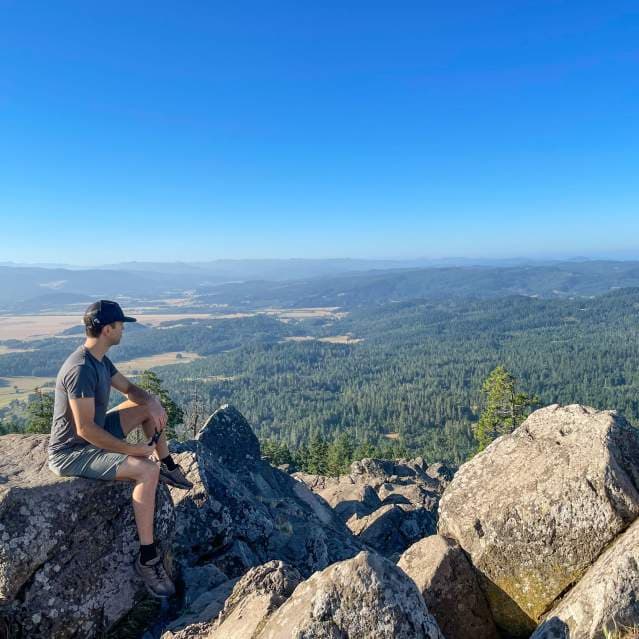
Spencer Butte is frequently called Eugene’s signature hike: “If Eugene has a signature hike, this is it.” The summit reaches 2,058 feet and offers “a sweeping panorama of the entire valley, on a clear day you can see from the Coast Range to the Cascades” and “wonderful panoramic views of Eugene and surrounding farmland, all the way to the Three Sisters mountains.” The summit vista has been described as “the marvelous vista at the top of Spencer Butte.”
Routes and distance: The Main Trail (Classic Summit Hike) is 1.7 miles round trip and rated moderate; it’s the most direct path from South Willamette Street, winding through Douglas fir and ending on volcanic rock outcrops. The West Slope Trail is about 2 miles round trip and is rated difficult; the Fox Hollow approach is longer with switchbacks if you prefer a less steep grade. The butte is part of Eugene’s Ridgeline Trail System (reported as a 12‑mile system), and you can link to adjacent parks such as Blanton Ridge.
Trailheads, parking and crowds: sources list South Willamette Street as the main trailhead and include conflicting street numbers (85219 and 85389 Willamette St are both reported). One source notes South Willamette trailhead has “ample parking, restrooms available,” while another emphasizes that most Ridgeline lots are small (10–15 spaces) and fill on sunny weekends. Arrive early on weekends or plan to park on nearby streets and walk in.
Family and safety notes: hikers report the final approach can be strenuous for small children, “After hiking this trail countless times with my kids at different stages, I would highly recommend a baby or toddler pack.” Pack layers and a headlamp for sunrise/sunset outings; one family cautioned to “be on the lookout for poison oak” after an encounter on the trail. Spring brings camas blooms that make a short wildflower detour worthwhile.
Local market/context note: high weekend demand for this short, high‑value hike drives modest local spending on gear (baby carriers, layers, footwear) and increases pressure on neighborhood parking. Retailers such as REI are specifically recommended by sources for carrier purchases, and second‑hand resale for carriers is active.
2. Ridgeline Trail system
The Ridgeline Trail “stitches together a series of forested hills that wrap around the city’s south end,” offering modular options: pick a short out‑and‑back or connect segments for a long day on rolling terrain and steady climbs. It’s repeatedly listed as one of Eugene’s three classic hikes alongside Spencer Butte and Mount Pisgah.
System length and character: Ridgeline is described as a 12‑mile system that includes Spencer Butte. Expect mixed forest, open ridges, pockets of city views and the chance to see hawks and barred owls.
Popular trailheads and parking (as reported): Blanton Trailhead (Blanton Rd), South Willamette Trailhead (reported as 85219 South Willamette St in one source), Martin Street Trailhead (Martin St & Fox Hollow Rd), Baldy Hill / Spring Blvd Trailhead (Spring Blvd & 57th Ave), and Spencer Butte North Trailhead (listed at 85219 Willamette St). Parking is generally free but often limited to roughly 10–15 spaces at many lots; again, “Show up before 9 a.m. and you’ll have no issues” on busy days.
Family notes: the system’s modular nature is ideal for families, choose a flatter segment or shorter out‑and‑back. Images preserved in the source material include family and dog scenes (e.g., “Golden doodle on hiking trail in autumn”), suggesting the Ridgeline is used for varied, family‑oriented outings.
Policy and access implication: the Ridgeline’s patchwork layout and small lots create uneven parking pressure in residential areas on sunny days. Local park managers may want to consider targeted investments in capacity or shuttles for peak days; users should check City of Eugene parks pages for any parking rules or time limits before visiting.
3. Mount Pisgah
Mount Pisgah is consistently grouped with Spencer Butte and the Ridgeline as a classic, must‑do day hike near Eugene. Sources list it as one of the three signature local hikes but do not provide distances, difficulty ratings, trailhead addresses, elevation, parking capacity or lookout specifics in the supplied material.
What to know now: include Mount Pisgah in your short‑hike itinerary planning, it’s within the same short‑drive geography as the other classic hikes, but verify trail distances, recommended family routes, parking and restroom availability from an authoritative local source before publishing or heading out.
Verification required (before relying on this entry for logistics): trail distances and difficulty, trailhead coordinates and parking capacity, lookout descriptions, and any seasonal advisories.
4. Delta Ponds
Delta Ponds appears in the supplied materials as one of the four featured day walks but the supplied snippets do not include concrete logistics such as distance, difficulty, parking, restrooms, or lookout details. Visual material preserved in the sources describes a flat, smooth gravel path and a wheelchair‑width pedestrian bridge through lush foliage, a scene that fits the Delta Ponds environment, but there’s no explicit trail-length or accessibility confirmation in the supplied excerpts.
What to do: Delta Ponds is a good candidate for families and accessible walks based on the imagery and general characterization, but confirm exact path length, parking and any wheelchair access details with an authoritative source (City parks pages or official Delta Ponds management) before relying on it for planning.
Orientation stop, Skinner Butte (short option) If you want a rapid “lay of the land” without a long climb, Skinner Butte is a quick alternative: you can hike up from the park below or “just drive to the top of Skinner Butte, so much easier!” The butte is described as “This classic 'lovers lookout'” with views over Eugene‑Springfield, Autzen Stadium to the east and Spencer Butte across the valley, ideal for a short family stop or to orient younger hikers before a longer trail.
- Spring on Spencer Butte and Ridgeline: camas blooms and other wildflowers make spring hikes especially rewarding.
- Wildlife: expect hawks, barred owls, and common understory plants like sword ferns and Oregon grape; watch for poison oak on some Spencer Butte approaches.
- Coastal notes preserved in research (not local day hikes): Baker Beach Trail, Hobbit Trail and Sea Lion Caves are coastal attractions mentioned in source material but are outside the Eugene day‑hike geography.
Wildflowers, fauna and seasonal highlights
- Resolve Spencer Butte trailhead address discrepancy (85219 vs. 85389 Willamette St) and confirm which trailheads have “ample parking” versus small 10–15 space lots.
- Verify Mount Pisgah trail distances, difficulty, parking, and lookout details.
- Confirm Delta Ponds trail length, accessibility (wheelchair paths/bridges), parking and restrooms.
- Check whether parking is truly free at each cited trailhead and whether any time limits or permits apply.
- Confirm the Ridgeline system length (reported as 12 miles) and precise connections to named trailheads.
Verification checklist (what to confirm before publishing or visiting)
Closing, with a local angle These four short walks and hikes, from Spencer Butte’s 2,058‑foot signature summit to Delta Ponds’ flat, bridge‑lined gravel paths, are practical half‑day plans for families living in and around Eugene. They combine easy access (all are within short drives of downtown), seasonal rewards (camas in spring, clear summit views to the Three Sisters) and modest gear needs; however, the mismatch in trailhead address data and parking descriptions in source material means trailhead and parking verification is a small but important step before you go. Small investments in planning (arrive early, pack a baby carrier or headlamp, check city parks pages) will keep outings smooth and reduce friction for neighbors and local businesses that see extra foot traffic on sunny weekends.
This article was produced by Prism’s automated news system from verified source data, official records, and press releases, then run through automated quality and moderation checks before publishing. The system is built and supervised by the people who set the standards it runs under. Read our full AI policy.
Did this article answer your question?


