Heavy Rain, Up to 3 Inches, Expected to Soak Eugene-Springfield This Week
A "long duration atmospheric river" is bringing up to 3 inches of rain to Eugene-Springfield through March 13, with a 12% chance totals hit that threshold.
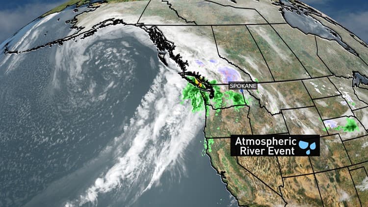
Snow that dusted eastern Lane County on Monday is giving way to something wetter: the National Weather Service has forecast a "long duration Atmospheric River" soaking northwest Oregon from March 11 through March 13, with Eugene-Springfield sitting squarely in its path.
The NWS puts Eugene's three-day rainfall estimate at approximately 1.64 inches, though forecasters were quick to flag the uncertainty baked into that number. Totals could come in below half an inch or climb past 3 inches. The agency put the probability of Eugene receiving 3 inches or more at 12%, and 4 inches or more at 6%.
The heaviest rainfall in the region is expected to fall across southwest Washington and the northern Oregon coast, but the storm's reach extends well down the valley, stretching as far south as Roseburg. The NWS said there is less than a 5% chance that rivers in the Willamette Valley will flood during the event.
Even below the flood threshold, the agency warned that standing water is likely on roads and that low-lying areas with poor drainage could see minor flooding. Sloped terrain faces a different hazard: rockslides, mudslides, and landslides are all possible where rain saturates hillsides.

The meteorology driving the storm is layered. According to weather science outlet The Watchers, two separate atmospheric rivers are affecting the Pacific Northwest beginning late March 10, fed by a plume of tropical and subtropical moisture tracking northward from near Hawaii. A mid-level ridge west of California is interacting with a broad trough over the Gulf of Alaska, generating strong westerly flow that channels that moisture toward Oregon and Washington. The first atmospheric river made landfall over Oregon late Tuesday, with a second, larger pulse arriving by Wednesday, March 12. Forecast models cited by The Watchers indicate the second pulse will deliver the bulk of the precipitation. CW3E model output shows a 75% probability of AR3-category conditions across parts of southwestern Washington and northwestern Oregon between March 11 and March 14, with integrated vapor transport values exceeding 250 kilograms per meter per second in those zones. In the Cascades and other mountainous terrain across the two states, precipitation totals of 180 to 380 millimeters, or roughly 7 to 15 inches, are forecast.
The NWS is the primary source for local guidance, and forecasters are expected to update probabilities as the second pulse moves through. Residents in areas prone to drainage problems or on steep slopes near the McKenzie River corridor and other eastern Lane County terrain should monitor NWS alerts as conditions evolve through Thursday.
This article was produced by Prism’s automated news system from verified source data, official records, and press releases, then run through automated quality and moderation checks before publishing. The system is built and supervised by the people who set the standards it runs under. Read our full AI policy.
Did this article answer your question?


