Highway of Legends links Las Animas County towns and mountain passes
The Highway of Legends turns Las Animas County into one connected travel corridor, linking Trinidad, Aguilar and the mountain passes with places to stop, spend and explore.
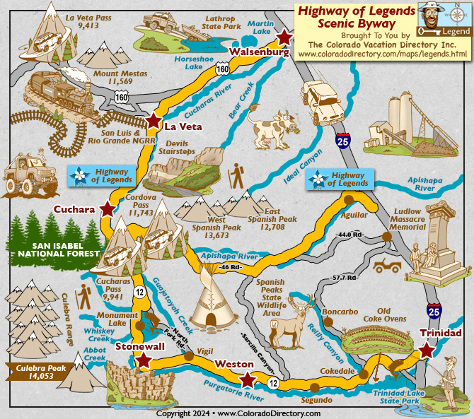
The Highway of Legends runs about 82 miles from Walsenburg to Trinidad in roughly two hours. A 35-mile extension from Aguilar follows County Road 46 through the San Isabel National Forest and reconnects to Colorado Highway 12 at Cucharas Pass. For Las Animas County residents and local officials, the byway is more than scenery. It can carry fuel, food, lodging, museum visits, trail access and mountain travel spending across several communities instead of concentrating it in one stop.
A county-sized route with real economic reach
Las Animas County is Colorado’s largest county, established in 1866 and spanning 4,775 square miles in the southern part of the state. The Highway of Legends helps stitch together places that might otherwise feel far apart: Trinidad, Aguilar, Walsenburg, La Veta and Cuchara all sit within the broader byway network tied to the Spanish Peaks. The result is a route that can support local businesses in multiple towns, not just a single destination at the end of the drive.
The Scenic Highway of Legends was designated a National Scenic Byway in 2021, and it is one of 13 America’s Byways in Colorado. Colorado also has 17 Scenic and Historic Byways designated by the state commission, placing this road among the routes that help shape tourism patterns across the state.
Trinidad is the southern anchor
Trinidad is the place where many travelers will feel the byway most immediately, because the road ties directly into a town with a preserved historic core, archaeology, architecture and a growing creative district. Visitors can turn a scenic drive into spending on restaurants, downtown shopping, lodging and cultural stops before heading out toward the mountain country.
Fishers Peak State Park adds a modern outdoor anchor to the Trinidad end of the route. Fishers Peak State Park became Colorado’s 42nd state park in April 2020, covers 19,200 acres and is defined by rugged topography, healthy ecosystems and abundant wildlife. Fishers Peak rises to 9,633 feet, and the Fishers Peak Trailhead opens access to more than 16 miles of trails for hiking and biking. That combination gives Trinidad a direct link between downtown activity and public-land recreation.
Aguilar opens the road into the forest
The 35-mile extension from Aguilar is where the Highway of Legends becomes a mountain access route in a very literal sense. County Road 46 carries the drive through the San Isabel National Forest and back to Highway 12 at Cucharas Pass, creating a forested leg of the trip that is different from the town-centered sections farther south. For visitors, that means a reason to buy gas, snacks, maps and gear in town before entering the pass country.
Aguilar is the place where the road shifts into a stretch that connects residents and travelers to higher elevations, forest scenery and the pass crossings that define the route’s character. For county leaders thinking about tourism-driven development, that transition can keep spending in local communities before vehicles climb into less-developed terrain.
The passes are the draw
Cucharas Pass sits at 9,994 feet and Cordova Pass at 11,248 feet, giving the byway a dramatic elevation range that takes travelers from town corridors to high-country viewpoints. Highway 12 rises to Cucharas Pass on the shoulder of the Spanish Peaks, where the road becomes part of the landscape rather than simply a way through it.
The Great Dikes of Spanish Peaks Country radiate outward from the Spanish Peaks and are a visible and unusual feature. The byway travels through an area rich in cultural history and offers options to cross Cucharas Pass or Cordova Pass.
History runs alongside the pavement
The route arcs around the Spanish Peaks, where gold-seeking conquistadors, Comanche, Pueblo and Tarahumara peoples once traveled. It ties the present-day drive to centuries of movement, trade, exploration and cultural meaning in southern Colorado.
State tourism materials also recognize the Southern Ute Indian Tribe, the Ute Mountain Ute Tribe and 51 contemporary tribes with historic ties to Colorado.
What makes the route practical for visitors
The Highway of Legends works because it gives travelers more than one reason to stop. In Trinidad, the draw is a historic downtown and cultural sites tied to the city’s creative and architectural identity. In Aguilar, the appeal is access to the forested extension and the pass country beyond it. In the smaller stops along the route, the value lies in the kind of spending that keeps rural main streets alive: coffee, meals, fuel, lodging, supplies and a few extra hours of exploration.
For Las Animas County officials watching tourism as a development tool, it links the county’s largest population center with mountain recreation and preserves a corridor where local business activity can benefit from passing traffic.
Part of a larger southern Colorado network
The Highway of Legends is part of a broader southern Colorado byway network. Frontier Pathways is another National Scenic Byway in southern Colorado, designated in 1998 and running through the Wet Mountains. Put together, the routes show how southern Colorado’s byway system works as a network of travel corridors rather than isolated attractions.
This article was produced by Prism’s automated news system from verified source data, official records, and press releases, then run through automated quality and moderation checks before publishing. The system is built and supervised by the people who set the standards it runs under. Read our full AI policy.
Did this article answer your question?