LANL Outlines Stewardship Efforts Across Soil, Air, Fire, and Water
LANL manages nearly 2,000 cultural sites and 68 radiological air stations across its 40-square-mile footprint, where canyons drain directly to the Rio Grande.
Los Alamos National Laboratory keeps close watch over a site that most people picture as a campus of secure buildings and lab-coated researchers. The full picture is larger: the Lab's facilities are spread across forest-filled canyons and mesas that funnel water to the Rio Grande below, covering roughly 40 square miles of the Pajarito Plateau. A staff-written feature published March 19 laid out how operations and stewardship teams manage that terrain, grouping the work under four headings: Earth, Air, Fire and Water.
The Earth section carries the deepest history. Lab archaeologists Sam Linford and Ali Livesay, who also helped create the Bradbury Science Museum's Homesteaders Exhibit, are among those leading this work. Human activity on the Pajarito Plateau spans more than 10,000 years, and the landscape reflects each era. Sites tied to Ancestral Puebloans, and more recently to homesteaders and the Manhattan Project, are federally protected. In total, the Lab carefully manages nearly 2,000 cultural sites and almost 500 historic buildings. At one homesteader site where Linford and Livesay have worked, part of a fireplace is all that remains of a log cabin. The Bradbury Science Museum exhibit highlights the stories of Pajarito Plateau homesteaders whose land was acquired for Project Y, later known as the Manhattan Project.
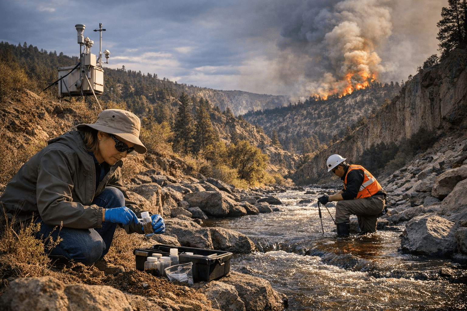
On the Air side, the Lab runs a continuous monitoring network of 68 radiological air sampling stations surrounding the Laboratory and its neighboring communities. Dave Fuehne, an expert in the Lab's environmental compliance programs, has explained the network's dual role: the stations measure air quality during normal operations and perform specialized sampling when wildfires break out. That compliance work satisfies regulatory requirements under permits including the Clean Air Act.
The wildfire-mitigation focus, listed as the Fire component of the stewardship framework, connects directly to that air-monitoring infrastructure. When fire moves through the canyon and mesa terrain, the radiological sampling stations shift to targeted monitoring, tracking what the smoke and ash may carry across the communities that border Lab property.
Water closes the four-part framework, grounded in a straightforward geographic reality: every canyon and mesa on the roughly 40-square-mile site eventually drains downhill toward the Rio Grande. The Lab's stewardship efforts treat the river corridor as an endpoint that concentrates the consequences of what happens on the land above.
The Homesteaders Exhibit at the Bradbury Science Museum was spearheaded by the Lab's Enduring Environmental Stewardship program, managed by Nell Larson, in coordination with Bradbury staff. The Bradbury Science Museum is the chief public facility of Los Alamos National Laboratory, located at 1350 Central Avenue in Los Alamos. Admission is free.
This article was produced by Prism’s automated news system from verified source data, official records, and press releases, then run through automated quality and moderation checks before publishing. The system is built and supervised by the people who set the standards it runs under. Read our full AI policy.
Did this article answer your question?