Los Alamos County trails span 150 miles, link canyons and mesas
Los Alamos County’s 150-mile trail web is built for daily use, with trailheads, leash rules and seasonal closures shaping every outing.
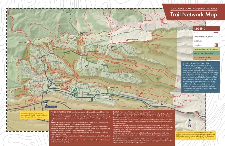
Los Alamos County’s trail system is one of the community’s most practical pieces of infrastructure. More than 150 miles of developed trails tie together canyons and mesas around town, while county Parks maintains 58 miles of trail and handles day-to-day operations on more than 50 miles within county open lands.
A trail system built into daily life
The scale matters because it changes how people use it. Los Alamos County also says it has 29 parks, 20 playgrounds, 600 acres of parks and 4,000 acres of open space, so a walk, run or bike ride does not need to feel like a special trip out of town. In practice, the network functions as a shortcut to fresh air after work, a place for family outings close to home and a way to reach scenic and historic areas without leaving the county.
The county trail network is for non-motorized use only, and its own guidance says many trails are easy to follow but may be rough, steep and challenging. That combination is typical of a mountain setting like Los Alamos, where trail users move between neighborhood edges, canyon bottoms and mesa tops instead of following flat park paths.
Where to begin: trailheads and access points
For residents trying to fit a trail into an ordinary day, the first decision is usually access. County trail pages point to places such as White Rock Canyon trailheads, the Aquatic Center Trailhead, Quemazon Trailhead and broader network maps that help match a route to the time available. Those access points matter because they let you choose between a quick outing close to town and a longer trip into canyon country.
The Aquatic Center Trailhead and Quemazon Trailhead are useful starting points when the goal is a shorter walk, an after-school outing or a bike ride before dark. White Rock Canyon trailheads open the door to a more dramatic landscape, with canyon corridors that make the system feel far larger than a neighborhood trail loop. The county’s historic-trails map adds another layer, showing that some routes follow old roads and historic paths rather than serving only recreational use.
If you are choosing by skill level, the county’s own map language is the best guide. A route that looks simple on paper can still be steep or rough underfoot, so the safest approach is to match the trailhead and the time window to the terrain you want, not just the distance you hope to cover.
Historic corridors and resource protection
Los Alamos trails are tightly linked to the county’s past. The historic-trails map frames the system as more than open-space recreation, because some routes follow historic roads and trails through landscapes that also contain cultural remains. County open-space guidance says cultural resources such as Ancestral Pueblo room blocks, pot sherds, petroglyphs and historical artifacts are protected by federal and state law.
That protection affects how people move through the system. Staying on established trails matters not just for safety, but also for preserving the resources that make these routes distinct from ordinary park paths. The county’s trail network is open for non-motorized travel, but it is also an active preservation landscape where the ground itself can carry historical significance.
Dogs, closures and changing conditions
The county’s open-space rules are specific about pets: dogs must be on a leash when within 100 yards of a trailhead and must be under voice and sight control beyond that point. That rule gives a practical boundary for people heading out with a dog, especially near busy access points where hikers, bikers and families may be starting or ending their outings.
Seasonal and situational closures can also change the day’s plan. PEEC’s trail guide notes that some trails may close because of poor conditions or wildlife alerts, and Los Alamos National Laboratory says construction impacts can affect public trail access, including White Rock area trail access in TA-70 and TA-71 tied to the Electrical Power Capacity Upgrade project. County open-space guidance also points to Stage 2 Fire Restrictions during dry periods, when land protection becomes part of the trail equation alongside recreation.

That means trail planning in Los Alamos is not just about picking a pretty route. It is also about checking conditions, respecting closures and knowing that access can shift because of weather, wildlife, fire risk or infrastructure work. The county system is resilient, but it is also a living network that responds to the landscape around it.
How big the network looks from the outside
Outside mapping services show how extensive the trail culture has become. TrailForks lists 358 trails on an interactive map of the Los Alamos mountain bike network, while TrailLink says Los Alamos has more than 37 trails covering 99 miles. Those numbers do not replace the county’s own mileage totals, but they show how widely the area is mapped and how many different routes people can choose from.
Taken together, the county totals and third-party maps tell the same story: Los Alamos trails are not a side feature. They are part of the county’s everyday mobility, recreation and land stewardship, with access points, terrain and rules that make them useful for a quick outing or a longer trip into the canyons and mesas that define the community.
This article was produced by Prism’s automated news system from verified source data, official records, and press releases, then run through automated quality and moderation checks before publishing. The system is built and supervised by the people who set the standards it runs under. Read our full AI policy.
Did this article answer your question?