Visitor Guide Details Bandelier's Ancestral Pueblo Dwellings and Local Connections
A visitor guide details Bandelier’s Ancestral Pueblo dwellings, trail network, and preservation work, highlighting access, safety, and tribal collaboration important to Los Alamos residents.

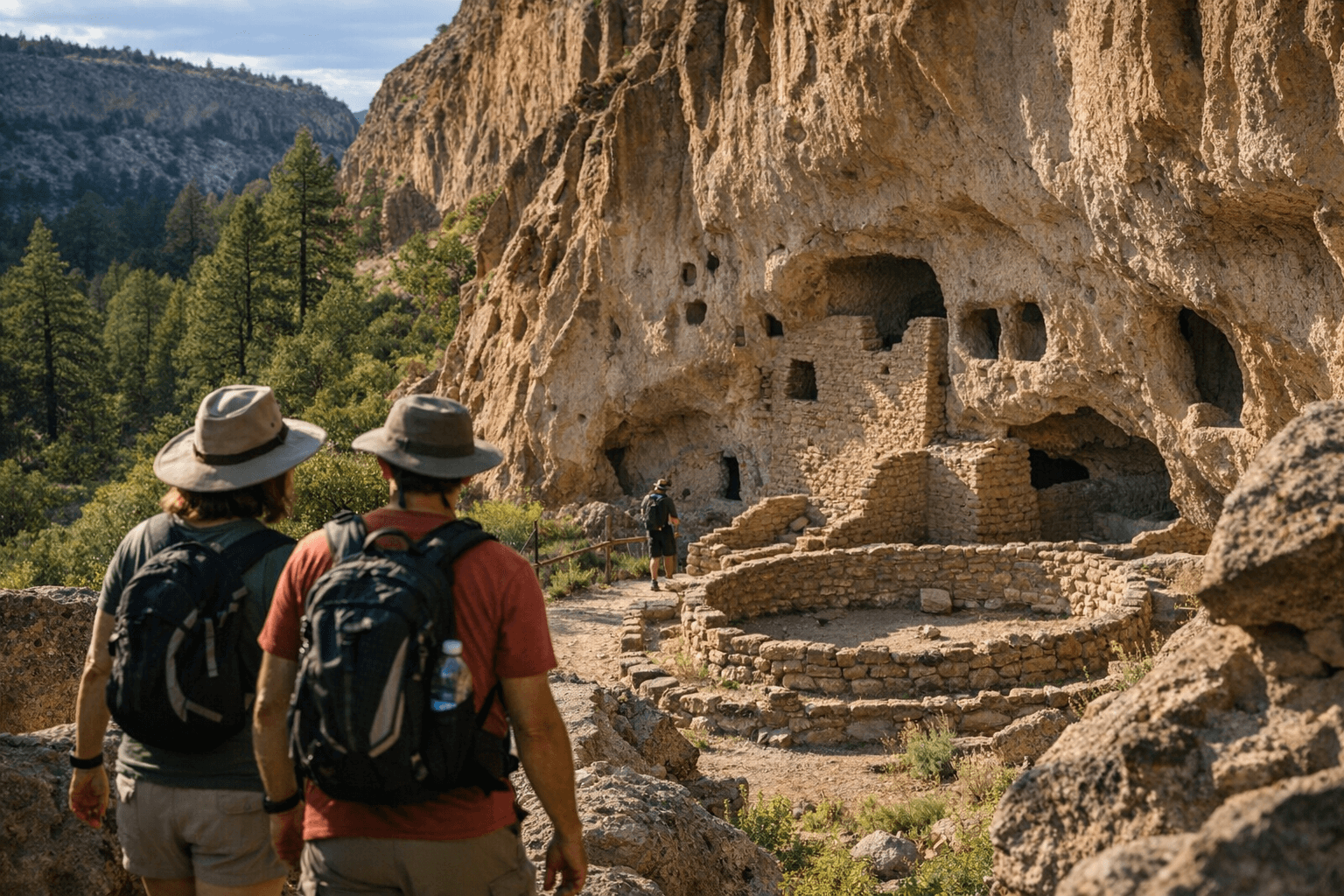
Bandelier National Monument preserves thousands of Ancestral Pueblo dwellings carved into volcanic tuff and remains a major cultural and natural destination for Los Alamos County and northern New Mexico. The monument covers more than 33,000 acres of canyon and mesa country, offers over 70 miles of trails that link into Santa Fe National Forest lands, and contains one of the largest concentrations of Ancestral Pueblo archaeological sites in the American Southwest.
Key sites in the main Frijoles Canyon area include Tyuonyi and the Big Kiva, as well as the cliff dwellings clustered along the Pueblo Loop Trail. The Pueblo Loop Trail, accessed from the visitor center, passes Talus House - the Cliff Dwellings that include four sites - and Long House, which includes six sites. Alcove House sits north of the Long Trail and can be reached by a 140-feet climb on four ladders. For experienced hikers, the recently rebuilt, eight-mile one-way Frijoles Canyon Trail gives the opportunity to travel downhill from the Ponderosa Group Campground to the visitor center.
Trails range from a short 1.4-mile loop to overnight backcountry trips in the Bandelier Wilderness. Popular routes include the Pueblo Loop, Alcove House Trail, and Falls Trail. Before the flash floods of 2011 the Falls Trail continued to the Lower Falls and ultimately to the Rio Grande; current routing and conditions should be confirmed before travel. The park also supports winter recreation, with trails suitable for cross-country skiing when conditions allow.
On-site facilities include the Frijoles Canyon visitor center, which is the hub for Pueblo Loop and Alcove House access and provides information and wilderness permits for backcountry travel. The park store and cafe sit southeast of the visitor center. Cottonwood Picnic Area, RV and backpacker parking lie south of the visitor center along Entrance Road. Juniper Campground sits southeast of Burnt Mesa Trail at about 6,600 feet elevation. The Tsankawi Section is located northeast of the park between Highways 501 and 4, with the White Rock visitor center and overlook to the south. Pajarito Road remains closed to the public.
Preservation and tribal collaboration are central to park management. The monument’s 2024 annual report noted that, "tribal involvement with management decisions was at an all-time high." Managers are addressing soil erosion that threatens cliff dwellings; "Reducing the number of trees and mulching the land allows grasses to grow and stabilize the soil, which also provides a healthy ecosystem." Ranger-led programs, from backcountry hikes to full-moon walks, are offered as staffing permits allow; check the National Park Service website or call the visitor center for current schedules.
Public health and equity considerations intersect with access and safety. The park’s elevation and ladder climbs can pose risks for visitors with heart or respiratory conditions, and the lack of lodging inside the monument means many rely on nearby towns such as Los Alamos, White Rock, Espinosa, or Santa Fe for overnight stays. Park messaging underscores visitor responsibility: "Please be safe, know your limits, and visit with respect." For Los Alamos residents, Bandelier remains both a local backyard for recreation and a shared responsibility to protect Indigenous heritage and fragile landscapes as access and preservation efforts continue.
This article was produced by Prism’s automated news system from verified source data, official records, and press releases, then run through automated quality and moderation checks before publishing. The system is built and supervised by the people who set the standards it runs under. Read our full AI policy.
Did this article answer your question?