Tug Fork Wildlife Management Area offers public access in McDowell County
Tug Fork WMA gives McDowell County a mapped public-land option for hunting, scouting and day trips, with WVDNR rules and seasons guiding every visit.
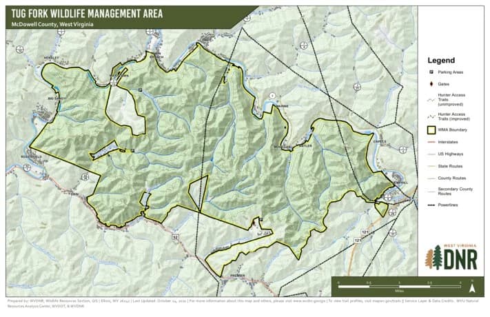
The West Virginia Division of Natural Resources map titled “Tug Fork Wildlife Management Area, McDowell County, West Virginia” gives McDowell County one of its clearest pieces of public ground: a mapped, regulated place where hunters, anglers, families and other outdoor users can plan a trip without guessing where public access ends. In a county often defined by coal heritage, private ridges and narrow hollows, it expands the places where you can legally step off the road and onto managed land.
Start with the map, not assumptions
It shows exactly the kind of terrain local users know well, steep and cut by branches and drainages. The PDF carries a scale of 1:28,000 and a 60-foot contour interval. In McDowell County, where a short drive can turn into a long climb or a narrow hollow, the map helps you judge how rugged a route really is before you head out. The document also labels nearby features such as Tug Fork, Shannon Branch, Spice Creek, Coon Tree Branch and Cub Branch, giving you real landmarks to match against the ground.
The map file is a November 2022 PDF in WVDNR records, so you can treat it as the agency’s current digital reference for the area. Use it to connect roads, drainages and ridge lines before you leave home.
How to get your bearings in McDowell County
Tug Fork WMA sits in McDowell County about 10 miles northwest of Welch, and the old map context places it along the U.S. Route 52 corridor between Welch and Iaeger.
If you are driving in from Welch, Iaeger or nearby communities, the first job is to match the county roads and hollows to the drainage names on the map. The WMA landscape is organized by branches and creeks more than by broad open trail systems, and the same terrain that makes the area attractive for hunting and scouting also makes careless navigation easy to regret.
That map-reading skill helps you understand where public land is, where it is not, and how Tug Fork WMA fits into a county where land ownership and access can change quickly from one ridge to the next.
Check seasons and rules before you go
Before any trip, check WVDNR’s District 4 Wildlife Management Areas page and its Wildlife Management Area Rules & Regulations page. The district page also points users to the state’s “See What’s In Season” tool and the “Check In Game” system, which are the practical tools that keep a trip legal and current.
If you are hunting, the agency’s hunting and trapping regulations summary for July 2025 through June 2026 is the reference to use before you pack the truck. That summary describes hunting and trapping as “longstanding traditions” that contribute to wildlife management, conservation and the cultural heritage of West Virginia, and the rules are built around that managed-use approach rather than simple open public wandering.
- Confirm the season for the species you want
- Make sure your license and any required entries are current
- Check the WMA rules before heading out
- Use the map to match your route with legal access and terrain
The safest habit is the simplest one:
On a WMA, the land is managed for both habitat and recreation. The rules are there to protect the resource and to keep users from assuming every road, hollow or ridge is open the same way it might be on a day hike in a town park.
What Tug Fork WMA offers beyond hunting
Tug Fork WMA is useful for more than a fall hunt. It can be a place to scout for deer and turkey sign, study county geography, learn how public land sits against private property, or just get a better read on McDowell County’s steep backcountry without having to own the ridge yourself.
For anglers, WVDNR’s district fishing guides and statewide fishing regulations show that access is organized around rules, seasons and location-specific details, just like hunting is. That same mindset helps when you are planning a day that may include a drive through the county, a stop near public land and a fishing trip somewhere nearby.
WVDNR’s 2022-2031 Trout Management Plan says nearly 100,000 anglers buy a trout stamp each year in West Virginia, and a West Virginia University survey cited in that plan found trout anglers fish an average of 57 days per year and travel nearly 90 minutes one-way to fish. WVDNR’s 2025 fishing regulations summary also says anglers broke eight state records in the prior year.
This article was produced by Prism’s automated news system from verified source data, official records, and press releases, then run through automated quality and moderation checks before publishing. The system is built and supervised by the people who set the standards it runs under. Read our full AI policy.
Did this article answer your question?