Gallup studies I-40 Exit 16 interchange to ease traffic, boost safety
Gallup still had no construction funding for Exit 16, but the study was weighing safer access and traffic relief for a busy I-40 gateway.
The question hanging over Gallup’s west side is simple: how long will it take to fix Exit 16, and who will pay for it before another round of congestion and crash risk keeps building?
A May 26 council update showed the city is still only studying the I-40 Exit 16 interchange, with planners looking at alternatives to correct physical and operational deficiencies, improve traffic flow, provide safer conditions, expand mobility options, and support regional growth and economic development. The update made clear that construction funding has not been identified and that money still has to be found to complete Phase C, the environmental stage.
That matters because Exit 16 is more than a local ramp. It is the westernmost Gallup interchange serving Route 66 and NM 118, and westbound I-40 drivers reach it through a 900-foot deceleration lane, according to the Gallup Area Transportation Safety Plan. The interchange was reconstructed in the early 1990s, and the city’s update suggests today’s traffic has outgrown some of the original assumptions.

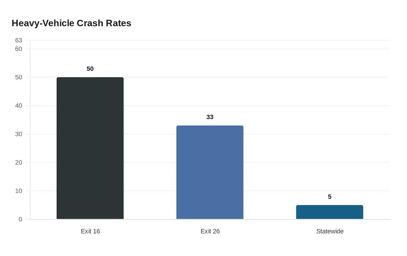
The safety picture is especially sharp. For 2020 through 2022, 50% of crashes at Exit 16 and 33% at Exit 26 involved heavy vehicles, compared with a statewide heavy-vehicle crash rate of 5%. The city also identified fixed-object, sideswipe and rear-end crashes as the main collision types in the corridor. That mix points to a roadway where freight, commuter traffic and local access are all competing for space.
The study is being led by the Northwest New Mexico Council of Governments in partnership with the City of Gallup and McKinley County, with coordination from the New Mexico Department of Transportation and the Federal Highway Administration. The team is doing technical investigations, coordinating with agencies, running public involvement, and developing recommendations based on technical analysis and public comments. That puts residents in the middle of the process before any final interchange plan moves ahead.
The Exit 16 work also sits inside a larger regional planning effort. The city update cited the Gallup Growth Management Plan, Gallup Transportation Master Plan, McKinley County Transportation Master Plan, Northwest New Mexico Regional Transportation Plan, 2021 Navajo Nation Long Range Transportation Plan, 4CITE, the 2019 Gallup Area Transportation Safety Plan, the 2021 ADA Transition Plan, the 2020 McKinley County Comprehensive Plan, the Gallup Economic Development Plan, the Gallup Mobility Hub, the New Mexico Mobility Strategy, the Gallup AV Track Feasibility Study and the Gallup Safety Action Plan.
That broader framework reflects the transportation reality in McKinley County, where Interstate 40 and US 491 cross through a corridor also shaped by BNSF rail infrastructure. The county’s role as a freight and mobility hub means a decision at Exit 16 will affect not just west Gallup drivers, but deliveries, emergency response and the region’s ability to handle future growth without making a dangerous chokepoint worse.
This article was produced by Prism’s automated news system from verified source data, official records, and press releases, then run through automated quality and moderation checks before publishing. The system is built and supervised by the people who set the standards it runs under. Read our full AI policy.
Did this article answer your question?


