Islamorada Eyes Shoreline Fix at Eroded Sea Oats Beach on Lower Matecumbe Key
RES Florida Consulting is studying whether an offshore breakwater or artificial reef could stabilize Sea Oats Beach at MM 74.5, where the Atlantic now reaches the edge of U.S. 1.

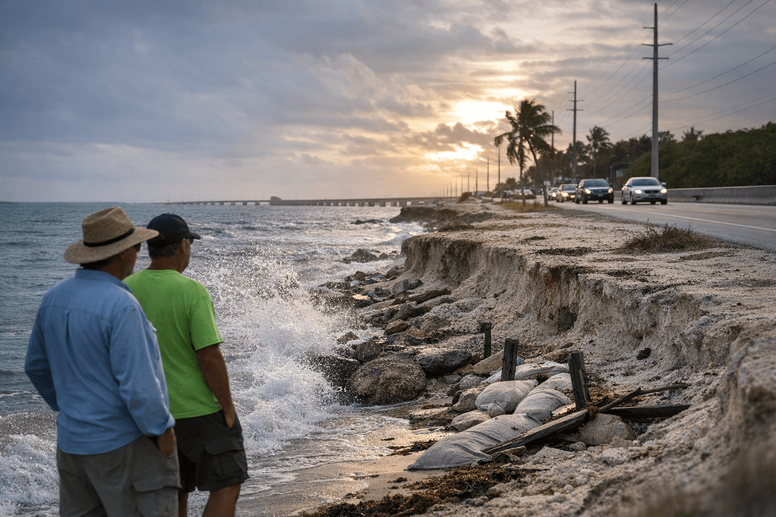
The Atlantic Ocean has been eating away at Sea Oats Beach on Lower Matecumbe Key for years, and the Village of Islamorada is now pursuing one of its most ambitious responses yet: a feasibility study for an offshore breakwater or artificial reef designed to hold what little shoreline remains at MM 74.5 to MM 75.
RES Florida Consulting, LLC submitted a proposal to conduct a feasibility study for a breakwater and artificial reef to implement shoreline stabilization at Sea Oats Beach and Upper Matecumbe Beach. The approach emerged from village meetings on June 24 and July 10, 2024, at which installing an artificial reef in critical areas as a breakwater was identified as a priority, and the village requested RES to provide a scope and fee for the feasibility study.
The Florida Department of Environmental Protection leaves no ambiguity about why the urgency is real. Its August 2024 "Critically Eroded Beaches in Florida" report classifies the Islamorada segment as critically eroded, threatening recreational interests, private development, and U.S. Highway 1 along Sea Oats Beach, from approximately 130 feet southwest of survey monument V345 to the groin approximately 1,900 feet southwest of V346. Sea Oats Beach is among a string of Monroe County shorelines carrying the same designation: a 2.1-mile stretch at Long Key State Park, 1.5 miles of Coco Plum Beach, 0.9 miles along Key Colony Beach, and a 0.5-mile segment at Sombrero Beach on Vaca Key are all listed as critically eroded in the same report.
The beach today has virtually no beach left and no sea oats, and with every storm, large or small, surf pushes sand from Sea Oats Beach directly onto U.S. One. The highway at Sea Oats Beach has been an area of huge concern for decades as the beach has eroded and the ocean at high tide is just feet from the pavement.
The planning record at the village goes back several years. Initial engineering for a stabilization project was submitted on September 23, 2020. At that time, village materials described a design phase expected to take one year and an estimated $10 million construction project slated to start in the spring or summer of 2022. Any additional runoff from the project was to be handled with drainage inlets, swales, trenches, and underground piping.
The road itself has also been a focus of intervention. Costs for raising shoulders and road from MM 73.9 to MM 76 with improved drainage were estimated at around $12.4 million, and FDOT also undertook repairs to the shoreline along Sea Oats Beach as part of a larger $6 million Hurricane Irma repair project up and down the Keys. FDOT's plan called for the highway by Sea Oats Beach to be raised by 2 feet, compared with 1 to 1.5 feet in most other locations along the MM 73.7 to MM 77.5 corridor. That plan drew pointed skepticism from residents, with one voice in the community framing the gap starkly: "There is no way to raise the road to address a 15-foot-high storm surge," Iglesias said. He had earlier urged patience, noting, "We understand you want to see something done quickly, but it has to be done the right way."
More than three years after Hurricane Irma, FDOT moved to stabilize the shoreline by repairing the embankment washout at Sea Oats Beach, re-using the erosion control articulating block mat installed during a 2008 highway shoulder stabilization, adding another layer, and placing rip-rap below grade.
Utility infrastructure at the beach faced parallel pressure. Once surrounded by more beach, FKEC transmission poles were being encroached on by the Atlantic Ocean; during Hurricane Irma, waves battered the equipment, nearly pushing over one pole and requiring emergency repairs. To significantly storm-harden the section, FKEC announced it would install new, improved poles on the opposite side of U.S. 1 between the Overseas Highway and a small side road on the bayside, improving both reliability and public safety by reducing the risk of a pole falling onto the highway. The project entered its beginning survey phase in April 2022.
Now, the proposed breakwater and artificial reef would use erosion control techniques to safeguard against storm surges at Sea Oats Beach and Upper Matecumbe Key Beach. The design is intended to protect sea turtle critical habitat identified by the U.S. Fish and Wildlife Service, including loggerhead sea turtle nesting areas, and would incorporate habitat components to aid water quality enhancements and shoreline protection, including seagrass. RES will also conduct a permit review to investigate whether a nearshore breakwater has previously been permitted in the Florida Keys.
The village's broader restoration work on Lower Matecumbe extends well beyond the beach. Islamorada contains 64 canals totaling approximately 24 miles across its four islands: Plantation Key, Windley Key, Upper Matecumbe, and Lower Matecumbe Key. The village is currently in various phases of canal restoration projects that include backfills, culvert pipe installations, air curtains, and injection well feasibility work. The most recent phase involves the Sandy Cove culvert project on the southern end of Lower Matecumbe, where Key Colony Beach-based LPS Contracting installed culvert pipes beneath Sandy Cove Avenue to hydrologically connect canals 155 and 157. The village is also seeking similar culvert connections for Lower Matecumbe Key canals 150, 151, 152, and 155. "I've been working on this for four years between the permitting and securing grant funding," said Peter Frezza, the village's environmental resources manager, describing the effort as the most expensive canal restoration project the village has undertaken.
At Sea Oats Beach, whether a breakwater built of artificial reef materials can succeed where decades of incremental fixes have fallen short remains the core question RES Florida Consulting is now being asked to answer.
This article was produced by Prism’s automated news system from verified source data, official records, and press releases, then run through automated quality and moderation checks before publishing. The system is built and supervised by the people who set the standards it runs under. Read our full AI policy.
Did this article answer your question?

