Amargosa Valley residents warn proposed conservation area would expand federal control
Amargosa Valley leaders backed an Ash Meadows conservation area, but residents say a 198,000-acre designation could hand more control to Washington and BLM.
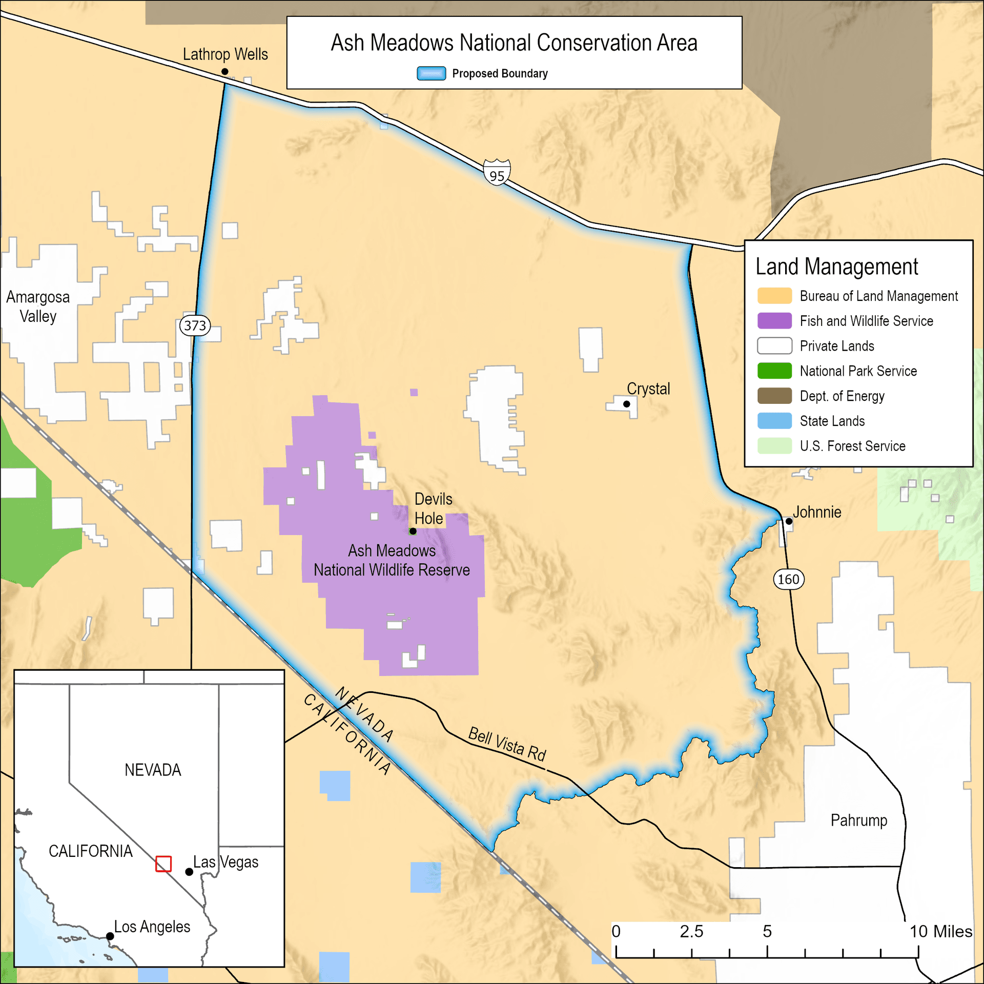
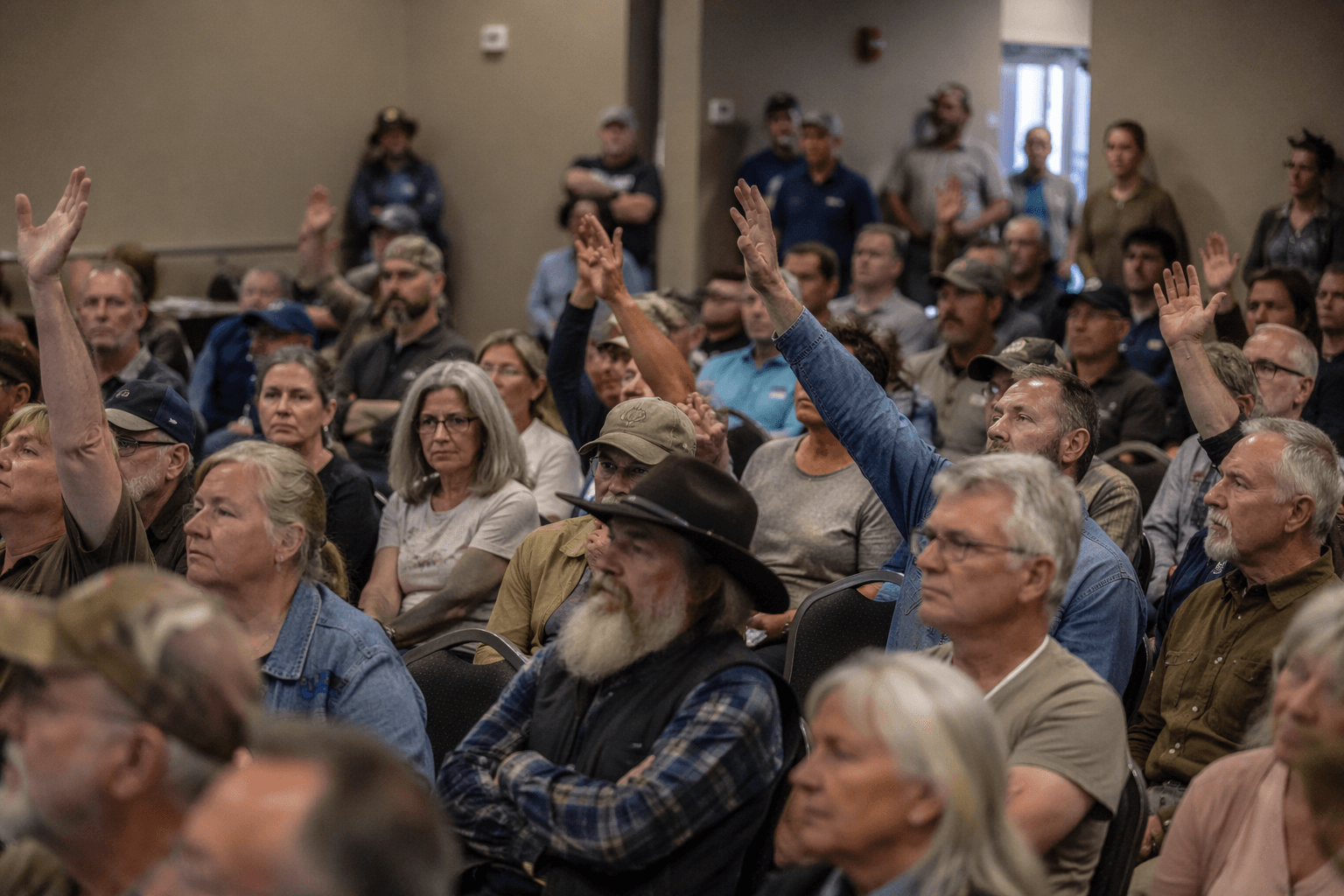
Amargosa Valley residents are warning that a proposed 198,000-acre conservation area around Ash Meadows would tighten federal control over land already 98% under federal management, with big consequences for access, permitting and future development in western Nye County. Critics say the plan would not just protect springs and wildlife, but could also give the Bureau of Land Management a stronger hand in deciding what happens across a landscape where private use is already limited.
The proposal has become a property-rights fight as much as a conservation debate. A recent report described a boundary of more than 185,000 acres around Ash Meadows National Wildlife Refuge, designed in part as a buffer against new solar farms. Local supporters say the designation is needed to protect the refuge’s fragile hydrology and the ancient groundwater that feeds its springs. Opponents say it would deepen federal influence over Amargosa Valley and surrounding Nye County at a time when residents are already wary of outside control over rural land.
Ash Meadows carries unusual weight in the region because of what is already there. The U.S. Fish and Wildlife Service says the refuge was established on June 18, 1984, covers more than 23,000 acres of spring-fed wetlands and alkaline desert uplands, and protects threatened and endangered species found nowhere else in the world, including pupfish that survive only in the refuge’s springs. The Nature Conservancy bought 12,613 acres slated for development in 1984 and transferred the land to the Fish and Wildlife Service to help create the refuge, a precedent supporters cite as proof that intervention has worked before.
The latest push comes as the basin faces repeated development pressure. Rover Critical Minerals had proposed up to 30 boreholes, 250 to 300 feet deep, near Ash Meadows before the Bureau of Land Management put the drilling on hold in 2023 pending a full environmental review. BLM’s 2024 Western Solar Plan also opened about 12 million acres in Nevada for solar development, including 220,000 acres in the Amargosa River watershed, adding to fears that the region could become easier to target once Greenlink transmission lines are built out.
The Amargosa Valley Town Board backed the conservation idea unanimously on March 26, 2026, saying it would help protect water resources and guide land use. The Nye County Commission later voted unanimously to support Ash Meadows protections as well, citing concern over the declining water table and saying the pressure on wells, wildlife and springs has become unacceptable. Even so, residents who oppose the proposal say a federal conservation area would leave local officials with less say over the land that surrounds them and the water that sustains the valley.
This article was produced by Prism’s automated news system from verified source data, official records, and press releases, then run through automated quality and moderation checks before publishing. The system is built and supervised by the people who set the standards it runs under. Read our full AI policy.
Know something we missed? Have a correction or additional information?
Submit a Tip