Beatty Serves as Southern Nye County's Gateway to Death Valley Adventures
Beatty, Nevada's only full-service town near Death Valley, sees dramatic seasonal traffic swings that affect fuel prices, emergency services, and road safety on U.S. 95 and Daylight Pass Road.
Sitting at 3,300 feet along U.S. 95, about 115 miles north of Las Vegas, Beatty is the last full-service town before Death Valley National Park swallows the landscape whole. For the roughly 1,000 people who live here year-round, that geography is both an economic engine and a recurring burden. Every surge of park visitors fills local gas stations and motel rooms, but it also floods local roads, strains a small emergency services footprint, and sends unprepared tourists into one of the most dangerous environments in North America, sometimes requiring rescues that fall on Nye County resources.
Understanding how Beatty actually functions, for both residents and the visitors passing through, is the practical starting point for anyone traveling this corridor.
The Local Stakes: What Tourism Traffic Means on the Ground
Seasonal visitor surges produce real swings in Beatty's service economy. Gas prices at the town's stations track closely with park visitation cycles; filling up here is almost always cheaper than the limited fuel options inside Death Valley, and locals notice when out-of-state demand spikes during spring and fall peak season. Lodging, similarly, compresses available rooms during popular travel windows, pushing prices upward and reducing options for workers and residents who need accommodations for extended stays.
On U.S. 95 and State Route 374 (the Daylight Pass Road corridor into the park), increased vehicle volume directly correlates with accident and breakdown calls. Daylight Pass Road runs perfectly straight for about nine miles after leaving the edge of Beatty, crossing the Amargosa Desert before entering California, where it becomes Daylight Pass Road proper. The road is visually deceptive: it looks simple, but summer heat, wildlife crossings, and drivers unfamiliar with desert distances create hazards that local EMS and law enforcement absorb. Cell service is unreliable or completely absent along much of this corridor and throughout large portions of Death Valley itself, meaning stranded visitors often cannot call for help and rescues require physical response.
Wild burros, which roam through and around Beatty, add another layer of road hazard, particularly at dawn and dusk. They require humane treatment and are not to be fed or approached aggressively; the animals draw visitors who sometimes stop unpredictably on U.S. 95, creating rear-end collision risks.
The 5 Mistakes That Generate Rescues and Tow Calls
Based on the consistent patterns of emergency responses in this corridor, these are the specific errors that put visitors in distress and require local intervention:
- Skipping the fuel stop in Beatty. Fuel inside Death Valley is scarce and priced at a significant premium. Travelers who pass through Beatty without topping off, assuming they can fill up later, frequently run dry on remote park roads where no services exist for 20 to 40 miles in any direction.
- Underestimating water needs. The National Park Service advises at least one liter of water per hour of physical activity in summer heat. Visitors who bring a single water bottle for a day hike, or who rely on finding water inside the park, create the majority of heat-related emergency calls in this region.
- Driving conventional vehicles onto ATV-only terrain. The Amargosa Dunes, southwest of Beatty, are specifically off-limits to conventional vehicles including four-wheel-drive trucks; only ATVs and dune buggies are appropriate. Chloride Cliff, accessible via a rough five-mile dirt road off SR-374, similarly demands high-clearance vehicles. Standard sedans and minivans driven onto these routes produce tow calls.
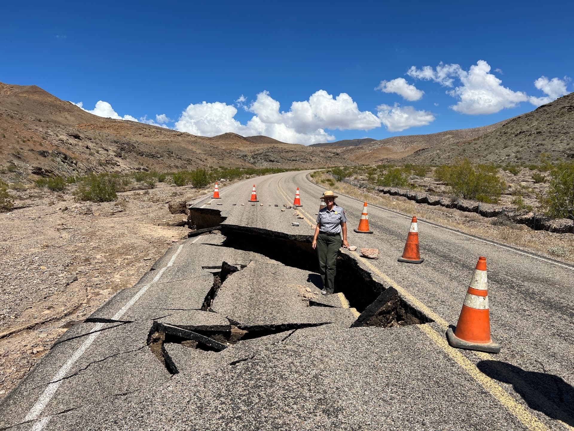
- Ignoring road condition updates before departure. Death Valley's road network remains vulnerable to flash flooding. Hurricane Hilary's remnants dropped 2.2 inches of rain on August 20, 2023, the park's single rainiest day on record, and damaged 1,400 miles of roads. Daylight Pass and the Beatty Cutoff were closed for months. Travelers who do not check current NPS road status before leaving Beatty can find themselves blocked at a closure or, worse, on a compromised road with no way to turn around safely.
- Assuming cell service is available for emergencies. Most of SR-374 and extensive areas inside Death Valley have no cellular coverage. If your vehicle breaks down in a dead zone, the protocol is to stay with your vehicle, raise the hood, and mark your location visibly. Driving or hiking away from a stranded vehicle in summer heat is how visitors die. A satellite communicator or personal locator beacon is the single most effective safety upgrade for this drive.
Getting Here and Getting Around
Beatty sits at the junction of U.S. 95 and SR-374. From Las Vegas, the drive north on U.S. 95 takes approximately 90 minutes under normal conditions. SR-374 west from Beatty is the primary road into Death Valley, connecting to Daylight Pass and giving access to the park's northern and central features. The road is paved and passable by standard passenger vehicles under normal conditions, but drivers should always verify current status with the NPS before heading out, given the route's flood history.
For travelers coming from the north on U.S. 95, Beatty is the last reliable stop before heading south toward Pahrump or turning west into the park. Six miles north of Beatty on U.S. 95, Baily's Hot Springs offers a 104-degree geothermal soak, a quieter stop that many visitors overlook.
What to See: Beatty's Immediate Attractions
The anchor attraction within reach of Beatty's town center is Rhyolite Ghost Town, located about two to three miles west on SR-374 and administered by the Bureau of Land Management. Rhyolite peaked in 1908 as a bustling mining center and collapsed nearly as quickly; what remains are photogenic ruins that reward early-morning visits when light and temperature are both manageable. Admission is free.
Directly adjacent to Rhyolite is the Goldwell Open Air Museum, addressed at 1 Golden Street in Rhyolite, about five miles west of Beatty. The outdoor sculpture park is open 24 hours a day, seven days a week, with free admission and on-site parking. The combination of Rhyolite and Goldwell makes for a half-day itinerary that requires no park entry fee and minimal driving.
Inside Death Valley, the major draws accessible via Beatty include Badwater Basin (the lowest point in North America at 282 feet below sea level) and Mesquite Flat Sand Dunes. Both require planning around temperature: summer visits to the valley floor are genuinely dangerous, and the park service is explicit about restricting strenuous activity to early morning hours from May through October. Beatty's 3,300-foot elevation keeps it meaningfully cooler than the valley floor during the hottest months, which is one practical reason to stay in town rather than inside the park.
The Beatty Museum and Historical Society offers local context for the region's mining and settlement history, useful grounding for visitors who want to understand why this string of ghost towns and desert outposts exists at all.
For active recreation beyond the park, Trails OV is in the process of developing approximately 300 miles of trail, including paved routes, in and around Beatty, with current options listed on Trail Forks. Rockhounding on BLM lands surrounding the area is permitted within standard federal rules: no motorized equipment, reasonable collection limits for personal use, and strict respect for posted private property boundaries.
Beatty's Amenities: Hours, Distances, and What to Count On
The Stagecoach Hotel and Casino, established in 1983, anchors Beatty's lodging and dining options. Its attached Denny's operates 24 hours, making it one of the few reliable meal options at odd hours in this stretch of U.S. 95. The casino itself runs 24-hour gambling year-round. Additional motels and RV parks serve visitors at price points generally well below what Death Valley's in-park lodging charges.
Gas stations in Beatty are the last affordable fuel before entering the park. Fill completely before departing, regardless of your current gauge reading. There is no shortcut back if you miscalculate distance in the park's interior.
For travelers with questions about current road conditions, ranger advisories, or local events, the NPS maintains a ranger station in Beatty. The agency's road status pages are the authoritative source for Daylight Pass and Beatty Cutoff conditions, and checking them the morning of any park visit is a habit that separates the prepared visitor from the one who generates a rescue call.
The civic organizations and local boards that govern Beatty's infrastructure manage a constant balance between promoting tourism and protecting the town's water supply, road quality, and desert surroundings. For a community this size, every spike in visitation has a direct and measurable effect on that balance, which is why the most useful thing a visitor can do, beyond personal preparation, is move through thoughtfully and spend locally.
This article was produced by Prism’s automated news system from verified source data, official records, and press releases, then run through automated quality and moderation checks before publishing. The system is built and supervised by the people who set the standards it runs under. Read our full AI policy.
Did this article answer your question?