Ohio River gauge warns Perry County of road, flood impacts
Perry County’s Ohio River gauge now turns water levels into plain road warnings, showing when Highway 66, locks, levees and riverfront access are in real trouble.

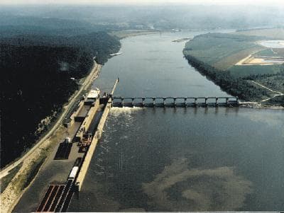
The Ohio River at Cannelton Lock and Dam page gives Perry County something river forecasts often do not: a direct read on when rising water starts to cut into everyday travel. For people driving Highway 66, reaching riverfront homes, or moving through Cannelton, Derby and nearby low-lying areas, the gauge translates river stage into immediate consequences on roads, locks, farms and recreation sites.
How to read the Cannelton gauge
The value of this gauge is not the number alone, but the local meaning attached to each stage. NOAA and the National Weather Service use river observations and forecasts as a color-coded monitoring tool across more than 6,500 streamgages nationwide, and the Cannelton Lock and Dam station is part of that network. USGS says the station is operated in cooperation with the U.S. Army Corps of Engineers Louisville District, which makes it an interagency river-monitoring point rather than a generic weather graphic.
That matters in Perry County because river height is not abstract here. It tells you when the Ohio is still below nuisance levels, when it is starting to threaten access roads, and when flood control structures and transportation links begin to fail in ways that affect daily routines. For residents who live near the river, work along Highway 66, or depend on crossings between Indiana and Kentucky communities, the gauge is a practical planning tool.
The thresholds that matter on the ground
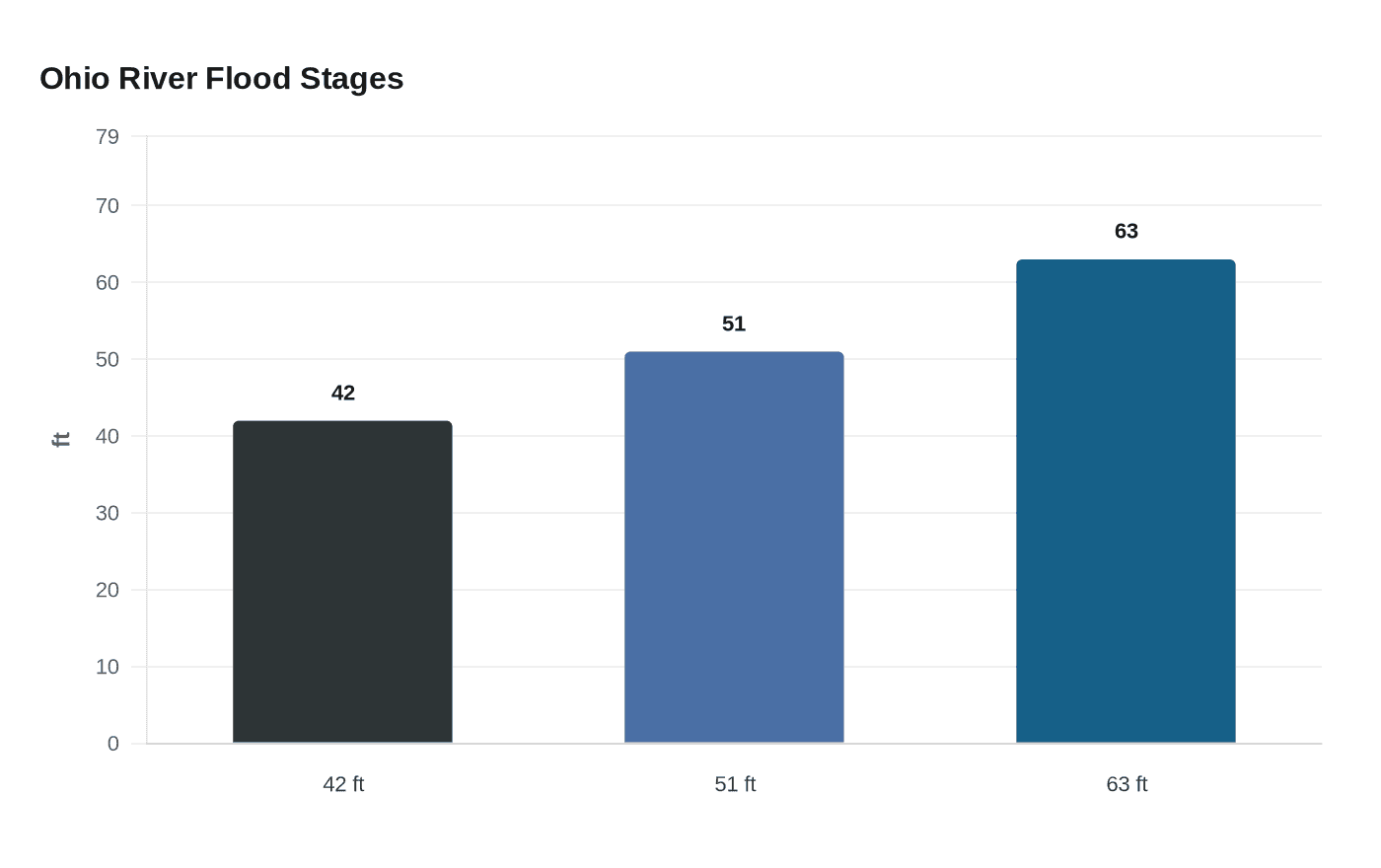
The most important number on the page is 42 feet. At that stage, agricultural flooding begins near Cloverport and Cannelton, Highway 66 floods near Derby and Dexter, and Rocky Point Girl Scout Camp is affected. That makes 42 feet an early warning point for people who keep vehicles in low spots, travel the river corridor every day, or depend on farm ground and camp access near the river bottom.
At 51 feet, the situation becomes much more disruptive. The locks are closed, large sections of Highway 66 flood, and Highway 60 floods between Cloverport and Hawesville. For commuters, freight operators and emergency responders, that is the stage when routine travel starts turning into rerouting, delays and possible isolation of river-adjacent roads. If you have errands, deliveries or shift work that depends on Highway 66, that is the point to expect serious disruption and adjust plans fast.
At 63 feet, the page says water reaches the top of the levee at Hawesville, Kentucky. That threshold is especially significant because it signals direct pressure on flood protection infrastructure on the Kentucky side and an elevated risk for river communities on both sides of the Ohio. Once the river is that high, people should think less about convenience and more about whether roads, access points and low-lying property can still be used safely.
What Perry County residents can use it for
For Cannelton, Derby and the nearby river communities, the gauge works best as a travel and property decision tool. If water is rising toward 42 feet, that is the time to check whether you need to move vehicles out of low driveways, avoid parking near river access points and reconsider nonessential trips through flood-prone stretches of Highway 66. When the river climbs toward 51 feet, the priority shifts to avoiding flooded road sections and tracking whether locks or adjacent routes are already shut down.
That practical value is what makes the page more useful than a general weather alert. It connects river level to specific places people know, including Highway 66, Highway 60, Cannelton, Cloverport, Hawesville, Derby and Dexter. Instead of guessing what a forecast means, residents can see when a rising river is likely to interrupt farm work, camp access, freight movement or the drive to town.
Who watches conditions and how official action follows
The county and state offices that matter most here are Perry County Emergency Management Agency and Indiana Department of Transportation. Perry County EMA says its mission is to mitigate, prepare for, respond to, and recover from emergencies and disasters affecting residents and communities, which places it squarely in the chain of agencies likely to track rising river conditions. INDOT also maintains a state restrictions-and-closings page and advises commercial drivers to consult bridge load restriction information, a reminder that flooding on and around State Road 66 has transportation and freight consequences, not just neighborhood flooding.
That state oversight is not theoretical. INDOT issued emergency declarations in 2025 for Perry County roads damaged by flooding, including State Road 166 and State Road 145. Those declarations show how high water can lead to longer-term roadway problems, including damage that remains after the river falls. When the gauge starts pointing toward flood-stage impacts, the likely official response is not just a warning, but road restrictions, closures and recovery work.
Why the recent flood history matters
Perry County has already seen how quickly heavy rain can turn into a countywide problem. NOAA’s Paducah office said multiple rounds of heavy rain and thunderstorms affected the lower Ohio Valley from April 2 through April 5, 2025. Indiana then issued a state disaster emergency on April 11, 2025, covering 18 counties, including Perry County. On July 22, 2025, a federal major disaster declaration covered severe storms, straight-line winds, tornadoes and flooding from March 30 to April 9, 2025.
The broader outlook also explains why the river is watched so closely. The National Weather Service’s spring hydrologic outlook in 2025 said flood potential across the Ohio Valley and its tributaries was normal to slightly above normal. In a county organized in 1814 and long shaped by the Ohio River corridor, that kind of outlook carries real weight because flood problems can move from forecast to road closure quickly.
The Cannelton gauge is therefore not just a technical river page. It is a local warning system for a county where 42 feet, 51 feet and 63 feet each mark a different level of trouble for roads, locks, camps and levees. For Perry County, the number on that page is often the first clear sign that the river is about to change the day’s plans.
This article was produced by Prism’s automated news system from verified source data, official records, and press releases, then run through automated quality and moderation checks before publishing. The system is built and supervised by the people who set the standards it runs under. Read our full AI policy.
Know something we missed? Have a correction or additional information?
Submit a Tip