College Park trails connect to wider Anacostia network, county says
College Park’s hiker-biker paths link into the Anacostia Tributary Trail System, turning local walks into countywide rides and giving neighbors more ways to move.
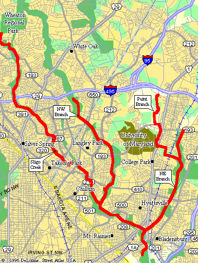
College Park’s trail map matters because it does not stop at the city line. The city says its residents and visitors have “miles and miles” of interconnected hiker-biker trails, and those paths plug into the Anacostia Tributary Trail System, making everyday walks and rides part of a much larger county network.
College Park as a gateway, not a dead end
The city’s trails and walking tours page names the connections that make the system useful in real life: the Paint Branch Trail, the Trolley Trail and the Indian Creek Trail. That matters for anyone trying to turn a neighborhood loop into a longer ride, or a quick campus-area stroll into an outing that reaches parks and adjoining communities.
TrailLink and AllTrails reinforce that larger picture. TrailLink lists the Paint Branch Trail as part of Prince George’s County’s trail inventory, while AllTrails describes it as a 9.1-mile out-and-back trail near College Park and places it inside the Anacostia Tributary Trail System. AllTrails also says it connects to the Indian Creek Trail and Northeast Branch Trail to the south, showing how one local route can feed into a regional corridor instead of ending at a parking lot or cul-de-sac.
Why the county treats trails as transportation
Prince George’s County’s own planning materials show that trails are not treated as a side project. The county released a public review draft of its Trails Master Plan in May 2016, then published a Strategic Trails Plan in July 2018 focused on bicycle and pedestrian trail development priorities. Those documents frame trails as part of countywide mobility, not just park access.
The county’s Adopt-A-Trail brochure makes that purpose explicit. It says pedestrian trails are used for leisure, recreation, transportation, bird watching, exercise and many other uses. In other words, the same corridor can support a morning bike commute, an after-dinner walk, a nature outing and a weekend family ride.
The institutional structure behind that work is just as important. Prince George’s County’s 2022 Land Preservation, Parks, and Recreation Plan says the Maryland-National Capital Park and Planning Commission is a bi-county agency created by the Maryland General Assembly in 1927. That long-running regional framework helps explain why the trail network looks the way it does today: the system is being shaped by planning bodies with countywide reach, not only by individual neighborhoods acting alone.
The specific routes residents actually use
For College Park, the practical question is not whether trails exist, but where they go. The city’s page identifies connections to the Paint Branch Trail, the Trolley Trail and the Indian Creek Trail, giving residents a route choice that can serve different trip lengths and purposes. That makes the network useful for students, families and workers who want to walk or bike without having to piece together a route from scratch.
The Paint Branch Trail is the clearest example of how the system works as one connected whole. At 9.1 miles, it is long enough to support exercise rides and longer recreational trips, while its connection south to the Indian Creek Trail and Northeast Branch Trail expands its reach beyond College Park itself. For a local resident, that means a trip can begin near home and continue into a wider trail spine that reaches other parts of the county.
What the Trolley Trail adds beyond recreation
College Park has also used the trail corridor for placemaking, not just movement. The city’s Trolley Trail Heritage Arts Project sits on the northern section of the Trolley Trail between Amherst Road and Greenbelt Road, and it was launched in partnership with the Anacostia Trails Heritage Area. That puts public art directly on the trail route people use to walk, bike and explore the area.
The placement matters because it turns a corridor into a civic space. A trail with murals, landmarks and visible activity feels different from a path that is treated as leftover land. In College Park, the Trolley Trail is not only a connector between neighborhoods and nearby roads. It is also a place where the city has decided to invest in identity and visibility.
Transit access and the University of Maryland connection
Trail planning in College Park also runs into transit and campus life. A 2022 Discovery District Multi-Use Trail Transit Access Plan was prepared for the City of College Park Discovery District working group, signaling that trail design is being tied to access for transit riders as well as walkers and bicyclists. That kind of planning matters in a city where many trips start or end near the University of Maryland and its surrounding districts.
SustainableUMD also frames the area around the university as a place where trails and green space matter for students, faculty, staff and visitors. That context helps explain why College Park’s trails function as more than leisure infrastructure. They serve a college town with a steady mix of daily commuters, campus users and people moving between residential blocks, parks and nearby commercial areas.
What makes the network feel complete, or incomplete
A real trail network depends on more than scenic segments. It needs clear connections, wayfinding and enough continuity that users can move from one corridor to another without guessing. Prince George’s County trail project materials reference Anacostia Tributary Trail System wayfinding signage, which is the kind of detail that helps a path feel like part of a larger system instead of a disconnected ribbon of pavement.
That is why College Park’s trail assets are best understood as a network of access points, not isolated amenities. The city’s own trail page points people toward specific regional routes, county planning documents show long-term investment in bicycle and pedestrian development, and the regional trail system gives those local paths countywide utility. For a resident heading out for a morning walk, a parent planning a family bike ride, or a commuter looking for a car-free connector, that difference determines whether the trails feel like a convenience or a true piece of public infrastructure.
College Park’s trail system works because it links neighborhood use to regional planning. The result is a set of paths that can carry everyday life, not just weekend recreation, and that makes the city one of the county’s most useful points of entry into the Anacostia Tributary Trail System.
This article was produced by Prism’s automated news system from verified source data, official records, and press releases, then run through automated quality and moderation checks before publishing. The system is built and supervised by the people who set the standards it runs under. Read our full AI policy.
Did this article answer your question?