Prince George's County green infrastructure plan maps habitat conservation priorities
Prince George’s County’s green infrastructure map is already shaping where land is protected, where growth can push, and where flooding risk stays highest. Its countywide habitat network now sits at the center of future zoning, stormwater, and tree-loss fights.
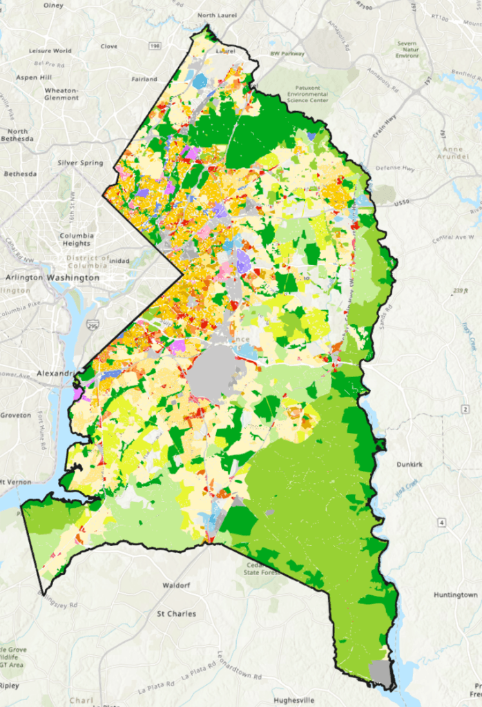
Approved on June 14, 2005, Prince George’s County’s Green Infrastructure Plan decides which forests, stream corridors, and habitat patches matter most when new roads, subdivisions, and public investments come into view.
It is a comprehensive vision for conserving significant environmental ecosystems in Prince George’s County, Maryland. It identifies interconnected sensitive habitats of countywide significance and pairs that map with implementation recommendations, making the plan a practical tool for land-use decisions rather than a purely environmental statement.

How the county draws the line between protection and growth
At the center of the plan is a simple idea with major consequences: not all green space is equal. The plan connects sensitive habitats into a countywide network, which means a wooded parcel, stream valley, or wetland edge may matter less as an isolated site than as part of a larger ecological system that links water quality, wildlife movement, and stormwater control.
That is why the plan reaches beyond parks. Its implementation section includes ordinance changes, policy guidance in master plans and sector plans, guidance for state and local land acquisition programs, and mitigation and development incentives. In practice, that gives planners and elected officials more than one lever when a development proposal lands near protected land or a drainage corridor.
The implementation time frame for the functional master plan is 2025, which keeps the plan active in current county decision-making. Environmental stewardship by private and public landowners is important to success, a reminder that the map only works if owners maintain tree cover, limit degradation, and cooperate with conservation goals.
What the plan says about water, trees, and flood risk
County planning materials put implementation of the 2005 Green Infrastructure Plan at 87%, while reporting that 52% of Prince George’s County was covered by forests and trees and estimating the annual stormwater value of canopy coverage at $12.8 billion.
In one county planning version, 93% of watersheds in 2005 had poor or very poor water quality, while a 2024 planning version uses 90% for the same year.
The 2010 Water Resources Functional Master Plan traces water quality damage to centuries of forest conversion to agriculture and to recent urbanization, resulting in degraded streams, declining forest and wetland habitats, and reduced recreational and economic opportunities from healthy water resources.
Where the plan meets development pressure
The Green Infrastructure Plan matters most when a parcel sits in the path of growth. County rules call for new development applications to be evaluated for their impact on the green infrastructure network, which means the county can press harder on subdivision layout, tree preservation, drainage design, and the siting of roads or stormwater facilities.
That puts the plan directly into future zoning fights. Areas mapped as sensitive habitat or connected ecological corridors are more likely to face pressure from property owners and builders who want to convert land, while neighbors and conservation advocates will point to the county’s own map when arguing for stronger protections, larger buffers, or different building footprints. The plan also influences park access and public acquisition priorities, because land identified as part of the network can become a candidate for conservation purchase or stronger preservation rules.
The county’s broader planning system reinforces that role. The Approved Prince George’s County Resource Conservation Plan, a countywide functional master plan approved in March 2017, embedded green infrastructure into a larger conservation framework.
Why the tree canopy numbers still matter
Tree cover in green infrastructure network regulated areas decreased from 74.1% in 2014 to 71.9% in 2018, according to Prince George’s County’s climate materials.
A separate county mapping source shows Prince George’s County had 53% canopy cover in both 2011 and 2021, while regulated-area tree cover declined from 74.1% in 2014 to 71.9% in 2018.
The county’s 2023 tree-canopy assessment for 2009-2020 says trees reduce stormwater runoff, cool pavement in summer, and provide wildlife habitat. It also says healthy canopy can improve social cohesion, reduce crime, and raise property values.
The long-range vision behind the map
The 2005 Green Infrastructure Plan set a 2035 vision of clean air, clean water, abundant wildlife habitat, and a healthy landscape.
Prince George’s County Planning Department and The Maryland-National Capital Park and Planning Commission remain the lead institutions behind that framework, with the Department of the Environment adding climate and canopy data that help show where the pressures are changing.
This article was produced by Prism’s automated news system from verified source data, official records, and press releases, then run through automated quality and moderation checks before publishing. The system is built and supervised by the people who set the standards it runs under. Read our full AI policy.
Did this article answer your question?