Marks Community Park revitalization takes shape at Marks gateway
Marks Community Park is being reshaped to do more than welcome drivers. The plan tackles flooding, downtown access, and daily use at the city's gateway.
At the corner of Mississippi Highways 3 and 6, Marks Community Park sits at the town’s entrance on flood-prone ground. The project is meant to serve as a gateway into Marks, while also giving the city a place that can handle stormwater, daily use, and the kind of upkeep a small Delta park needs after heavy rain.
What the park is meant to do
The park is currently unnamed in the formal plan, even though locals know it as “The Mule Train” Park. The site marks the entrance to town, supports recreation, and sits in a flood-prone spot where design choices have to solve a real drainage problem rather than just improve appearances.
The Mississippi Department of Transportation owns the property, and the city of Marks leases it for an annual fee. City crews manage the park now, handling turf work and litter control, so the revitalization is building on an existing maintenance role rather than starting from scratch.
How the project grew beyond a sign
The park effort did not begin as a full redesign. Velma Wilson, Quitman County’s economic and tourism director, first reached out to Mississippi State University’s Department of Landscape Architecture about improving the entry sign into Marks. That request expanded into a broader park concept once the school began looking at the site’s layout, drainage, and long-term use.
A sign alone would not fix what residents know from experience after storms: the water hangs around too long. The landscape management plan identifies flooding, and the length of time water remains on the site after a storm, as the park’s biggest constraint.
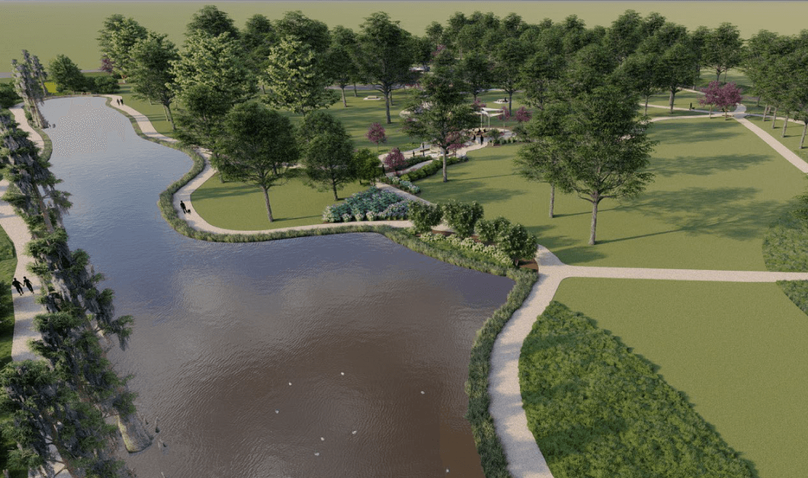
Why drainage is the heart of the design
The plan points to a practical toolkit for making the park work better. Proposed improvements include walking trails, interpretive signage, a wet pond, stormwater management tied to Cassidy Bayou, a learning garden, seating, and trash receptacles. It also calls for better vegetation care, including trees, shrubs, perennials, and open turf, along with seasonal maintenance calendars that spell out how the site should be cared for across the year.
The wet pond and Cassidy Bayou drainage work are intended to help manage water on a site where standing water is already part of the problem, while the trails and seating make the park useful when the ground is dry enough for people to linger.
How the Mule Train story fits the site
Quitman County’s interpretive trail planning was supported by a $50,000 National Park Service African American Civil Rights grant, which backed a three-year planning and implementation process for the Marks Mule Train and Martin Luther King Jr.’s Poor People’s Campaign trail. That process included town hall meetings, community mapping, and voting that selected eleven locations for the trail.
The earlier “Marking the Mule” project at Mississippi State received a $25,000 National Endowment for the Arts Our Town grant in July 2015. That work drew on oral histories, outreach at a blues festival, a hands-on design charrette, and repeated feedback loops with residents, historians, planners, architects, and preservation officials. It also produced a trailhead marker that doubled as a welcome sign at Highway 6, U.S. Highway 278, and M.L.K. Jr. Drive.
Quitman County places the Mule Train’s arrival in Washington, D.C. on June 19, 1968.
Why downtown Marks changes the stakes
The park is not standing alone. On March 15, 2024, the National Park Service certified Downtown Marks as a Historic District. The district covers about one square mile and includes 88 buildings and structures, with 67 contributing resources and 21 non-contributing resources. That designation places the park project inside a broader effort to shape how people enter, move through, and understand the town center.
Cassidy Bayou Landing and Jamison Landing in the Marks area once handled steamboat traffic and ferry service until the railroad expanded.
This article was produced by Prism’s automated news system from verified source data, official records, and press releases, then run through automated quality and moderation checks before publishing. The system is built and supervised by the people who set the standards it runs under. Read our full AI policy.
Did this article answer your question?