Valles Caldera showcases volcanic history, wildlife and scenic access
The supervolcano in Sandoval County’s backyard is dormant, but not extinct. Valles Caldera’s road rules, cashless fees and seasonal access decide how much of the preserve you actually get to see.

The supervolcano in Sandoval County’s backyard is dormant, but not extinct. Valles Caldera National Preserve covers about 88,900 acres in the Jemez Mountains, and the easiest family day trip starts on NM-4 at the Valle Grande entrance, where the main gate and Volcano Discovery Center set the pace for the rest of the visit.
Why this landscape pulls people back
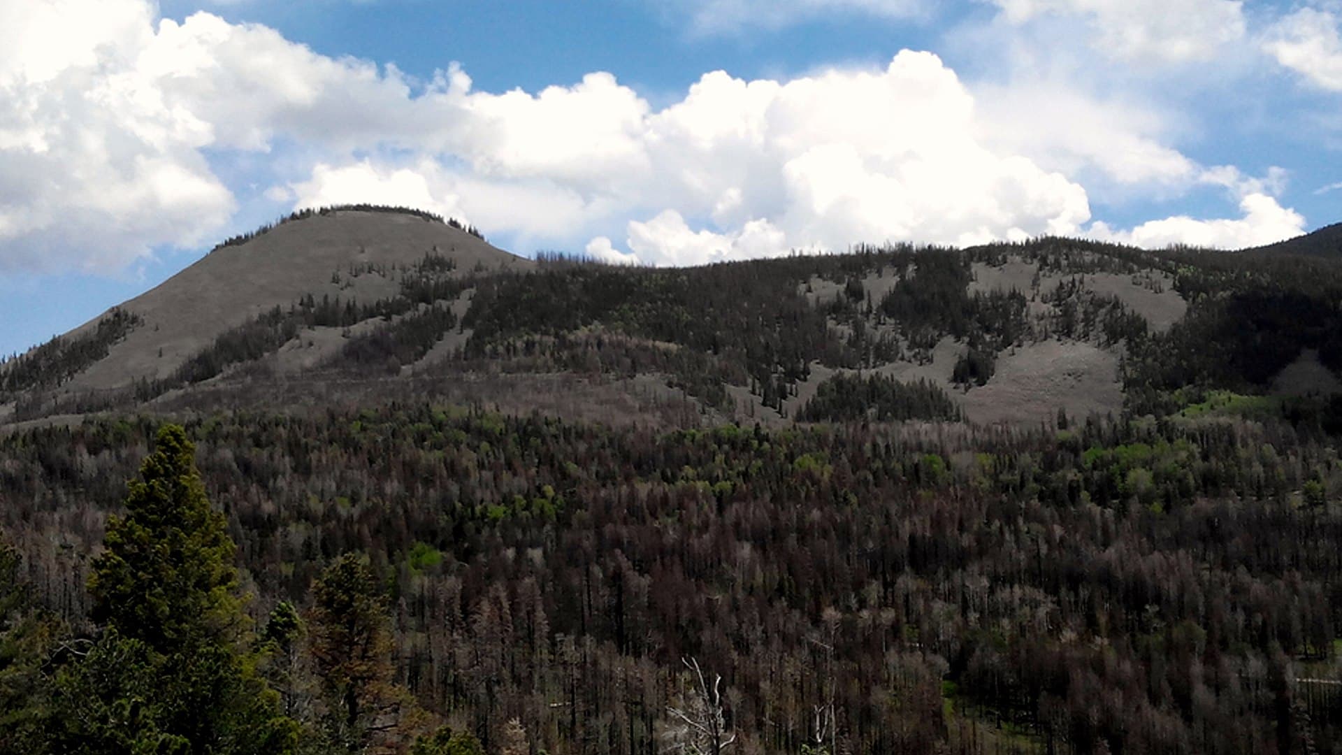
About 1.2 million years ago, a massive eruption created the caldera, and the preserve now sits inside almost all of that volcanic bowl, with hot springs and fumaroles still marking the geologic system as active. Redondo Peak rises to 11,254 feet, and the high-elevation mix of grasslands, forested domes, streams and ponderosa pine gives the park a look you do not get at Bandelier or in the nearby national forest lands around it.
Several thousand elk live here, along with mountain lions, bears, bobcats and coyotes. At least 40 bird species of conservation concern and 3 endangered wildlife species are known to occupy the preserve, according to the National Park Service. The preserve also emphasizes night skies and watershed protection.
How to get in without wasting a trip
For Sandoval County families, the main entrance is the Valle Grande gate on NM-4, near mile marker 39.2 and about halfway between Jemez Springs and Los Alamos. Motorized vehicles can enter almost every day from 9 a.m. to 5 p.m., with summer hours stretching to 8 a.m. to 6 p.m. from Memorial Day to Labor Day. The pedestrian pass-through gates stay open from dawn to dusk every day of the year, and travel along NM-4 itself is available year-round when weather allows. Thanksgiving and Christmas are scheduled vehicle-gate closure days, and dangerous driving conditions can trigger additional delays or closures.
Once you are inside, the useful first stop is only 4 miles down the entrance road in the Cabin District. The Volcano Discovery Center is the preserve’s sole public visitor-services building, with rangers, maps, a park store, interpretive signs, spotting scopes and an immersive eruption simulation that runs every hour on the half-hour. There is no flush restroom or potable water there, only portable toilets in nearby parking areas. Accessible parking and a wheelchair ramp are available at the back entrance.
What access really looks like on the ground
Road surface is the biggest trip-up for first-time visitors. The roads into and through Valles Caldera are gravel and dirt, with ruts and potholes common enough that caution is essential and high-clearance vehicles are a good idea beyond the Cabin District. Weather can change those roads quickly, and winter driving on NM-4 in the Jemez Mountains can turn treacherous, with snow-pack and ice lasting for days or weeks. The VC09, South Valle Toledo, Posos Trail is closed for restoration, so do not assume every route shown on a map is open today.
The backcountry route is seasonal, which means timing matters if you want more than the front-country view. From May 15 to November 15, motorized vehicles can reach the backcountry with a pass, but only 40 vehicle passes are issued per day, and remaining passes are first come, first served at the Volcano Discovery Center. The route is closed to vehicles from November 15 to May 14, so a fall plan can turn into a dead end if you do not check the calendar before leaving home.

What it costs
The preserve is cashless, so do not count on paying with bills at the entrance station. A private vehicle pass costs $25 and covers seven consecutive days for the driver and passengers in that vehicle; a motorcycle pass is $20 for seven days; and pedestrians or cyclists age 16 and older need their own pass at $15 for seven days. Valles Caldera also sells an annual park pass for $45, and America the Beautiful passes are accepted.
The two experiences that make the drive worthwhile
If you only have a few hours, start at the Volcano Discovery Center and then take the short walk or porch pause with a straight view over Valle Grande. The center’s eruption simulation is the easiest way to understand the landscape before you head outside, and the front porch looks straight out over Valle Grande, where spotting scopes help with elk and bird watching. If you want a quieter, easier second stop, the Cabin District Interpretive Trail and History Grove are close enough to fit into the same visit, and History Grove sits about 0.8 miles beyond the center as one of the preserve’s last remaining pockets of old-growth forest.
For people willing to keep driving, the backcountry is the version that justifies planning ahead. The route runs from the Cabin District through the middle of the preserve and into Valle San Antonio and Valle Toledo when conditions allow, with grasslands, volcanic domes and long views of Redondo Peak.
The deeper story behind the scenery
Valles Caldera carries 12,000 years of human history, and it is culturally connected to at least 38 affiliated tribal nations, according to the park. The preserve is especially important to the Pueblo of Jemez, and its self-guided Hemish connections tour features voices from Chris Toya, Brophy Toledo, Byron Andrew and Mark Magdalena. The land was also long known as Baca Ranch or Baca Location No. 1, later becoming a public preserve after federal acquisition in 2000, congressional re-designation in 2014 and National Park Service management beginning on October 1, 2015.
Grasslands here historically burned every 3 to 12 years, and current management includes resting and burning grazing areas about every ten years to mimic that natural fire behavior and improve grassland health. The preserve’s 2011 and 2013 wildfires burned two-thirds of the land. Prescribed burns can send smoke toward nearby roads and towns, and people with respiratory problems or heart disease should take that seriously when smoke is visible in the Jemez.
This article was produced by Prism’s automated news system from verified source data, official records, and press releases, then run through automated quality and moderation checks before publishing. The system is built and supervised by the people who set the standards it runs under. Read our full AI policy.
Know something we missed? Have a correction or additional information?
Submit a Tip