How Seminole County classifies and builds its trail network
Seminole County's trail plan is a map of access, not just miles: big regional corridors, neighborhood links and wilderness paths each serve different daily trips.
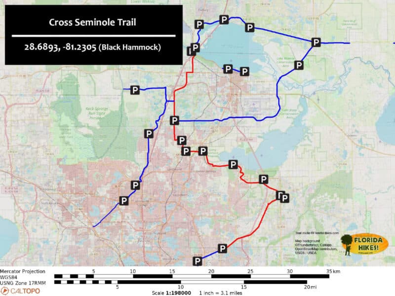
The Cross Seminole Trail stretches about 27.69 miles through Oviedo, Winter Springs, Longwood, Lake Mary and Sanford, a scale Seminole County treats differently from the short connectors that link a subdivision to a school in its 2021 Trails Master Plan.
How Seminole County organizes its trails
The plan lays out a countywide logic: Seminole County trails history, the 2020 public engagement process and summary findings, the hierarchy of the trails system, implementation, and attachments. The structure treats trails as infrastructure with rules, priorities and tradeoffs, not as scattered amenities.
Seminole County’s Leisure Services Department, through Parks, Trails and Natural Lands, oversees more than 7,300 acres of parks and natural lands and 130+ miles of paved and wilderness trails. At that scale, a classification system is what helps the county decide which routes should function as regional backbones, which should carry local trips, and which should preserve a more natural experience. The county’s 2024 Recreation and Open Space Element adds another layer: state law requires the county’s recreation-and-open-space chapter to identify a comprehensive system of public and private recreation sites, including natural preservation areas, parks, playgrounds, parkways, beaches, public access to beaches, open spaces, waterways and other recreational facilities.
What each trail type means on the ground
Seminole County divides trails into five categories: Signature Trails, Pathway Trails, Connector Trails, Wilderness Trails and Destination Trails. Each category maps to a different kind of trip in Oviedo, Winter Springs, Longwood, Lake Mary, Sanford and the unincorporated areas in between.
Signature Trails are the big regional corridors. These are the names most residents know, including the Cross Seminole Trail and the Seminole Wekiva Trail, and they are the backbone of the countywide network. The 2022 Cross Seminole Trail land management plan lists the corridor as 14 feet wide in most areas. It also states that 11.3 miles are owned by the Board of Trustees of the Internal Improvement Trust Fund in two segments, and FDOT owns 1.85 miles of the corridor.
For everyday use, Signature Trails are the routes most likely to support longer bike rides, distance runs and cross-town trips. They are also the trails where maintenance, access points and continuity matter most, because a break in one segment can affect the usefulness of the whole corridor.
Pathway Trails are more local. The plan uses them for routes that connect neighborhoods, schools, parks and civic spaces, which makes them the most obvious fit for family walks, short bike rides and trips that begin or end near home. If a resident wants a trail that feels close to daily life rather than a special trip, Pathway Trails are the category designed for that need.
Connector Trails close gaps between separate systems or link a neighborhood to a larger corridor, and that makes them some of the most consequential pieces of the network even when they are not the most visible. In practical terms, these are the links that can turn a disconnected trail segment into a useful route for commuting, errands or a safer ride to another part of the county.
Wilderness Trails serve a different purpose altogether. These are natural-surface trails inside preserves and conservation areas, which makes them the best match for residents who want a less built environment and for users who value a quieter, more ecological setting. They are not built for the same kind of constant through-traffic as a paved corridor; they are built to move people into Seminole County’s natural lands without turning those places into urban infrastructure.
Destination Trails are trails worth a trip on their own because they lead to a distinct place or experience rather than just functioning as daily transportation.
Why the county’s 2020 update process matters
Seminole County updated the 2021 master plan after a 2020 public engagement process and released chapter videos on history, terminology and introductions as part of the update. Trail planning is not only about design standards; it is also about which gaps residents notice, which routes they trust and which links they want built next.
Trail priorities in Seminole County are shaped not just by geography and land ownership, but by input on how people actually move through the county and where the network feels incomplete. In a place with more than 130 miles of paved and wilderness trails, the most important decisions are often about connecting what is already there.
Where residents feel the difference
The county’s trail hierarchy is most useful when it turns abstract planning into everyday movement. Families care about whether a pathway trail reaches a park without forcing a car trip. Commuters care about whether connector trails close the gap between their neighborhood and a regional corridor. Runners and cyclists care about continuity across longer Signature Trails, and nature seekers care whether Wilderness Trails preserve the surface and setting that make a preserve feel like a preserve.
The county’s classification system is a map of access and tradeoffs. A paved regional corridor can move a different mix of users than a narrow natural-surface trail in a conservation area, and a short connector can change the usefulness of an entire neighborhood trail cluster.
The long view for Seminole County
Seminole County has been planning trails for decades, and the 2021 update sits inside a longer effort to knit together recreation, transportation and conservation. The county’s planning documents place trails within a broader land-use system through hierarchy, implementation and public input.
This article was produced by Prism’s automated news system from verified source data, official records, and press releases, then run through automated quality and moderation checks before publishing. The system is built and supervised by the people who set the standards it runs under. Read our full AI policy.
Did this article answer your question?