Severe thunderstorm warning issued for south central St. Louis County
A warning covered Duluth, Cloquet and Superior through 6 p.m. Tuesday, with 60 mph gusts, quarter-size hail and the risk of outages.
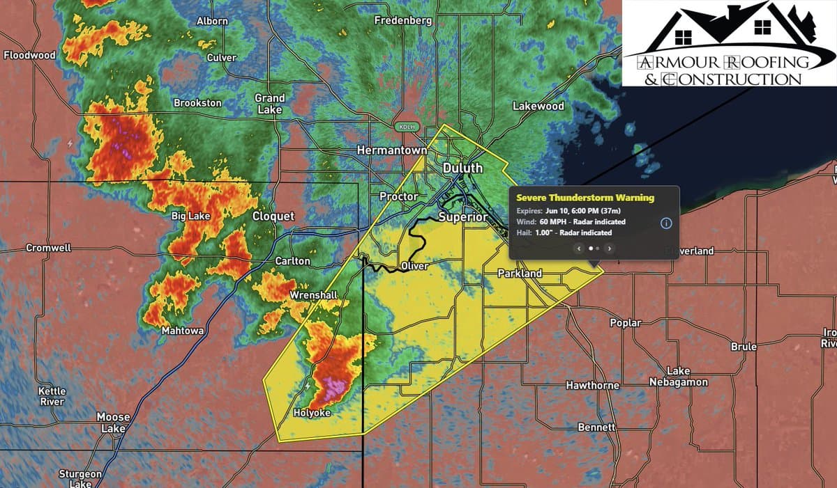
A severe thunderstorm warning covered south central St. Louis County, including Duluth, Cloquet and Superior, through 6 p.m. June 10 as a storm system pushed northeast at 30 mph with wind gusts up to 60 mph and quarter-sized hail. For a county that includes Duluth and its transportation network along Lake Superior, the biggest immediate risks were downed limbs, power outages, hail damage and dangerous driving.
National Weather Service Duluth said the warning came amid several rounds of thunderstorms expected across the Northland that afternoon and evening. Forecasters said numerous severe storms were possible, with all severe hazards on the table, including large to very large hail, damaging wind gusts, tornadoes and locally heavy rainfall. A severe thunderstorm watch had also been in effect earlier for St. Louis County and Carlton County, along with parts of northwestern Wisconsin.
The storm threat was not limited to one corner of the county. National Weather Service Duluth later recorded a preliminary hail report of 1.00 inch in Nett Lake at 6:50 p.m. June 10. That report noted strong winds, but no evidence of wind damage, underscoring how fast-moving storms can bring large hail even where major structural damage does not immediately appear.

The broader weather pattern was active across Minnesota and the Upper Midwest. National Weather Service Twin Cities said widespread rain showers were expected June 11, followed by a much cooler and drier air mass settling over the region. In its forecast discussion, it said below-normal temperatures were likely, with highs in the 70s, and a break from the heat and humidity over the next week.
That cooler pattern was expected to follow additional shower and storm chances in the Northland. National Weather Service Duluth said more non-severe showers and storms were expected June 11 and June 12, then cooler temperatures into the weekend and early next week. Its text products also warned that severe thunderstorms and showers could still produce large hail, a few strong tornadoes, damaging winds over 75 mph and localized flash flooding across parts of the Mid and Upper Mississippi Valley and Midwest.

The same storm period also hit the state’s power grid. More than 54,000 Xcel Energy customers in Minnesota lost electricity after overnight storms, a sign that utility crews could face additional cleanup as the system moved on. For St. Louis County, where even brief outages can ripple through neighborhoods, traffic signals and business corridors, the warning was another reminder that severe weather in the Northland can turn disruptive fast.
This article was produced by Prism’s automated news system from verified source data, official records, and press releases, then run through automated quality and moderation checks before publishing. The system is built and supervised by the people who set the standards it runs under. Read our full AI policy.
Did this article answer your question?