Twin Ports Faces More Heavy Snow After Major St. Louis County Storm
Southern St. Louis County is under a winter storm warning as a second major storm threatens 6-12 more inches for Duluth days after 9.3 inches buried the region.

The Twin Ports barely finished clearing roads from one significant snowstorm before a second, larger system bore down on the region, placing southern St. Louis County under a winter storm warning and threatening Duluth with an additional 6 to 12 inches through Monday morning.
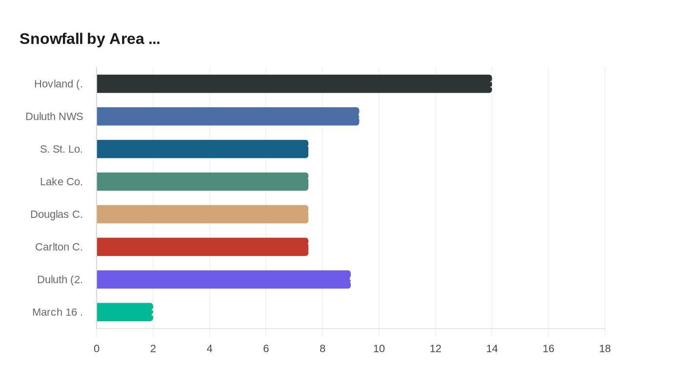
Snowfall that began Thursday evening had already deposited 9.3 inches at the National Weather Service's Duluth offices by 9:30 a.m. Friday. Observers across southern St. Louis, Lake, Douglas and Carlton counties reported accumulations in the range of 6 to 9 inches from that first storm, while the North Shore saw considerably more: a maximum of 14 inches was observed northeast of Hovland in Cook County. On March 16, Duluth recorded an additional 2 inches, compounding the accumulation burden on roads and infrastructure still being worked by plows.
Attention then shifted to an incoming system that the Duluth News Tribune characterized as "a second, much-bigger storm system," though one expected to deliver a glancing blow to most of the Northland. The bulk of the storm was projected to track south and west of Duluth, but the city was still predicted to absorb 6 to 12 inches through Monday morning alongside strong north winds.

The geographic footprint of warnings reflected where the heaviest impacts were expected to concentrate. Southern St. Louis County was placed under a winter storm warning, while the North Shore up to Silver Bay fell under a winter weather advisory. Freezing spray and gale warnings were active along Lake Superior, where large waves rolled in and struck rocks along the shoreline. Grand Rapids and the Iron Range were forecast to see only mild to moderate snow, with impacts dropping off substantially to the north.
Southern Carlton and northern Douglas counties were expected to see slightly more accumulation than the Twin Ports. The heaviest totals in the broader region were forecast well to the south and east: snowfall could total a foot or more along a corridor stretching from St. Cloud through Hinckley, Solon Springs and into Ashland.
The second storm arriving within four days of the first left the region with little recovery window. Street crews that had been working to clear the initial accumulation faced the prospect of starting again before the job was finished.
This article was produced by Prism’s automated news system from verified source data, official records, and press releases, then run through automated quality and moderation checks before publishing. The system is built and supervised by the people who set the standards it runs under. Read our full AI policy.
Did this article answer your question?