Old Hardesty tells Texas County’s vanished-town story
Old Hardesty shows how a cattle stop became a lost town, then an archaeological site, when rail lines and federal projects rewrote Texas County.
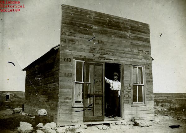
Old Hardesty sits about four miles northeast of today’s Hardesty, but its story reaches much farther than a vanished townsite. The first settlement rose in 1886 at the confluence of Coldwater Creek and the Beaver River, where cattle trails, railroad maps, and federal land policy all collided in the Oklahoma Panhandle. What remains there now is not just a curiosity from the past, but evidence of how Texas County communities were built, rerouted, and sometimes erased.
A town built where the county was still being claimed
Old Hardesty took shape near the Jones and Plummer Cattle Trail, which funneled cowboys through the area on the way to Kansas. The wider region was still coming out of No Man’s Land, and settlement had been delayed until the federal government ruled in 1882 that the area was public domain, then softened the way for settlement after the 1885 squatter-rights ruling. In that setting, the U.S. Post Office Department approved a Hardesty post office in 1887, and the town took the name of rancher A. J. “Jack” Hardesty.
By 1889, the place had a newspaper, the Hardesty Times, and later papers included the Hardesty Herald and the Hardesty Kicker. That matters because it shows Old Hardesty was never just a camp on the prairie; it was trying to function like a real town, with mail, print, trade, and a local public life. The town’s early growth followed the same logic that shaped so many Panhandle settlements: people and businesses gathered where routes converged and where the next shipment, herd, or headline might arrive.
The railroad that moved the map
The turning point came in 1901, when the Chicago, Rock Island and Pacific Railway bypassed Old Hardesty and laid its line roughly 18 miles west, creating Sanford, later Guymon. Businesses and residents moved with the rail connection, and the town’s economic center went with them. The U.S. Army Corps of Engineers later described Old Hardesty as abandoned in 1901 after a 17-year existence, and by 1906 one local writer said the old town was gone.
The decline did not stop there. By 1911, the original site had been reduced to a country post office, a thin remnant of the community that once tried to anchor this corner of Texas County. That sequence is the hard lesson in Old Hardesty’s history: in the Panhandle, a railroad adjustment could decide which town grew, which one withered, and which one became a footnote.
Why the name returned
The Hardesty name came back in 1929, when a second railroad line was built through Texas County and investors revived the community under the same name. The present town incorporated in 1947, but it was not a simple continuation of the old settlement. It was a new Hardesty shaped by the same regional forces, especially rail access, agricultural trade, and the constant pressure of small-town economics.
The census numbers show how modest that recovery remained. Hardesty’s population was 201 in 1950, 187 in 1960, and 223 in 1970. Those figures tell you that this was never a boom town in the modern sense; it was a small community held together by the kinds of institutions that still matter in Texas County, including local roads, schools, churches, and the routines that keep a town viable even when it never gets large.
What archaeology preserved
The old townsite was partially excavated in 1975 before Optima Lake was created. Archaeological Research Associates carried out the test excavations under contract with the Tulsa District of the U.S. Army Corps of Engineers, turning a lost settlement into a documented site. The Old Hardesty Archaeological Site is listed in the National Register of Historic Places as NR 74001669, which helps keep the town visible even though the original buildings are long gone.
That excavation gives the site its lasting value. Old Hardesty is not only about nostalgia for a vanished town; it is about what the ground can still show after a community disappears. For Texas County, the site offers a record of frontier settlement, rail-era business decisions, and the everyday lives that rarely survive in official maps but do survive in archaeology.
The land around it still tells the story
The modern landscape around Old Hardesty also carries the mark of another big change. The Optima Lake project was authorized by the Flood Control Act of 1936, Congress approved preconstruction money in 1962, construction began in 1966, and Optima Dam was completed in 1978. The lake never filled as expected, which left much of the old landscape more visible than planners likely imagined.

That same area became home to the 4,333-acre Optima National Wildlife Refuge in 1975. The U.S. Fish and Wildlife Service manages it for resident wildlife and migratory birds, and the refuge was established to provide habitat on the planned Optima Lake. In practical terms, the land around Old Hardesty moved from cattle trail country to railroad country to an archaeological site and a wildlife refuge, each layer changing how people use and remember the place.
Why Old Hardesty still matters in Texas County
Old Hardesty is a local story about more than one town. It shows how the Panhandle’s boom-bust pattern has always been tied to infrastructure, whether that infrastructure was a cattle trail, a railroad, a post office, or a dam. It also shows how land use in Texas County can change faster than local identity does: the original town vanished, but its name, its records, and its footprint still shape how Hardesty, Guymon, and the surrounding county understand themselves.
That is why the old site still matters now. It explains where the county came from, how federal decisions and private investment redrew its map, and why the ground northeast of Hardesty still deserves a place in the story of Texas County.
This article was produced by Prism’s automated news system from verified source data, official records, and press releases, then run through automated quality and moderation checks before publishing. The system is built and supervised by the people who set the standards it runs under. Read our full AI policy.
Did this article answer your question?