NTSB: La Grande Pilot's Helicopter Struck Slackline, Killing Four
A La Grande pilot's helicopter struck a suspended slackline near Superior, Arizona, killing four. The NTSB preliminary report raises questions about line marking and NOTAM notifications.

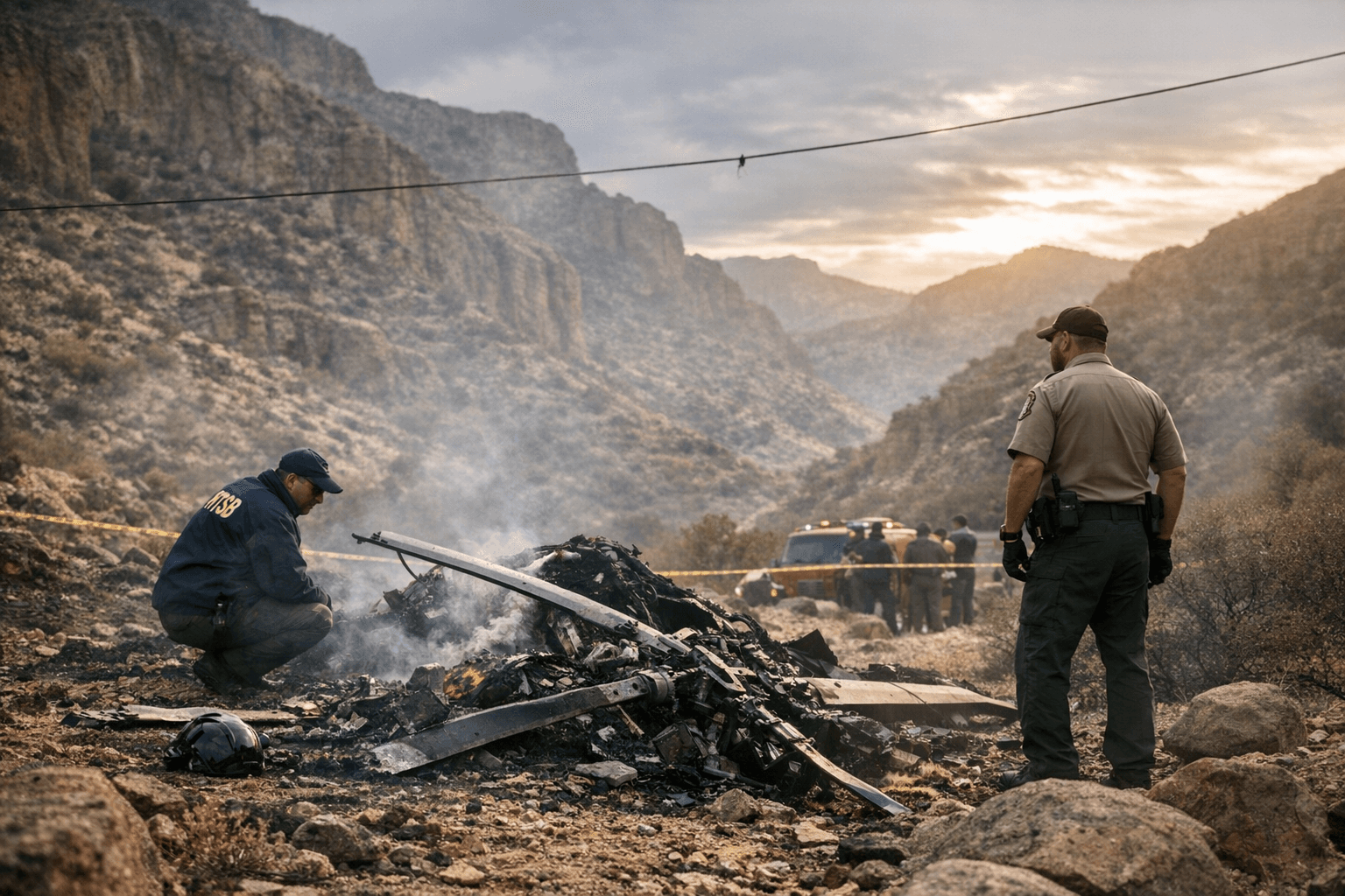
A helicopter piloted by David McCarty, 59, of Baker County struck a suspended slackline and crashed near Superior, Arizona, killing McCarty and three passengers: Rachel McCarty, 23; Faith McCarty, 21; and Katelyn Heideman, 21. The helicopter was operated by McCarty, who owns Columbia Basin Helicopters in La Grande and maintained a home in Queen Creek, Arizona.
The National Transportation Safety Board preliminary report describes the equipment involved and the sequence that led to the impact. “Slacklining is a sport where a participant balances on a 1 to 3 inch wide piece of webbing made from synthetic fiber that is suspended between two fixed points. A subset of the sport, called highlining, entails rigging the slackline at higher altitudes above terrain, and often involves longer slacklines. Typically, a highline/slackline consists of a mainline that the participant balances on, and a backup line that the participant connects their safety harness to. The mainline is tensioned between two anchors, and the backup line is loosely attached to the mainline with intermittent connectors.”
Investigators found that slackliners had anchored lines on bluffs about 0.74 mile apart and raised a signalization line carrying five windsocks and about ten LED lights. The mainline and backup line were estimated to be about 600 feet above the ground at their highest point in terrain with elevations between 2,600 and 3,500 feet mean sea level. Witnesses told investigators the lines had been lowered on Dec. 30 ahead of high winds and rain, then were being redrawn on the morning of Jan. 2 when a helicopter approached and struck the lines.
According to the NTSB summary, a witness saw the helicopter impact the lines; the aircraft appeared to slow or reverse direction, pitched nose up, and yawed to the right. The tailboom separated, the fuselage inverted, and the tailboom and fuselage struck terrain about 150 and 350 feet from the lines. Examined wreckage contained material consistent in appearance to highline/slackline webbing embedded in the upper part of the vertical stabilizer; striations matching the webbing weave were visible on the vertical and horizontal stabilizers and on two main rotor blades. Emergency responders later observed a second helicopter fly about 10 feet under the still-suspended signalization line.
The report notes that a friend of the slackliners filed a Notice to Airmen on Dec. 21 alerting pilots to a “tight rope” about three nautical miles south of the Superior airport, effective Dec. 26 through Jan. 6. That NOTAM was listed for the Superior airport but was not listed for Pegasus Airpark in Queen Creek, where McCarty began the flight.
The International Slackline Association posted a public statement on Jan. 3: “The International Slackline Association (ISA) is heartbroken to learn of a tragic incident that occurred in the United States on January 2nd 2026 in which a helicopter collided with a 1km long highline. The highline had aviation markers attached to it. The FAA had been informed of the highline and a NOTAM (Notice to Air Missions) had been issued before the collision. The FAA and the National Transportation Safety Board are investigating the incident. Four passengers aboard the helicopter have been confirmed deceased. No highliners were on the line at the moment of the incident. We extend our deepest sympathy and condolences to all of those affected by this tragic event. Further information will be shared as it becomes available through official sources.”
For Union County residents and the local aviation community, the crash underscores practical safety and policy questions: how temporary aerial hazards are notified across nearby airfields, how recreational groups coordinate with aviation authorities, and how local operators verify NOTAM coverage before flight. NTSB spokesman Keith Holloway said a final report likely will be released within 12 to 24 months. In the near term, pilots should verify NOTAMs through FAA channels before departure, and recreation organizers and landowners should confirm notification and marking procedures so aircraft and outdoor users can share airspace and terrain safely.
This article was produced by Prism’s automated news system from verified source data, official records, and press releases, then run through automated quality and moderation checks before publishing. The system is built and supervised by the people who set the standards it runs under. Read our full AI policy.
Did this article answer your question?