Valencia County's Unified Fire Reaches 50% Containment After Crews Strengthen Lines
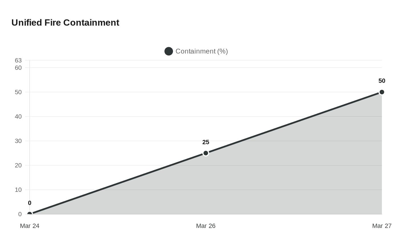
Containment lines on the Unified Fire held against 25-40 mph wind gusts, pushing the 300-acre bosque blaze to 50% contained — but suppression crews warned interior heat remained active.
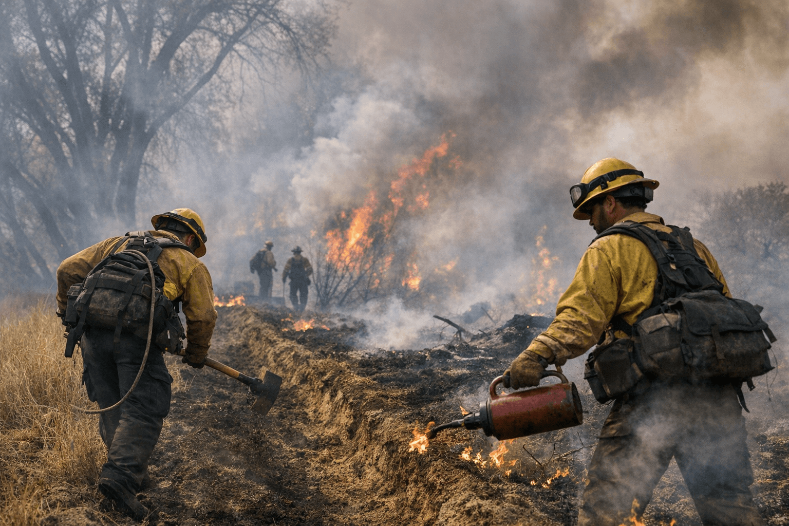
Half of the 300-acre Unified Fire burning through the bosque near Madrone was successfully boxed in after containment lines survived a serious test from wind gusts forecast at 25 to 40 mph out of the east-southeast. But the milestone carried its own caution: the other half of the fire's perimeter remained unsecured, crews were still hunting pockets of interior heat within the burned footprint, and forecasters warned the same wind pattern that challenged lines on March 26 could return.
The fire ignited at 10:49 a.m. on Tuesday, March 24, east of Interstate 25 and south of Rio Communities in the Casa Colorada area, burning through a volatile mix of grass, brush, timber and timber understory. Its cause remains under investigation. Within hours, residents along Madrone Flyway and Lagrima Road near the river were evacuated, State Highway 304 was closed at Sonnenburg Loop and Baca Road, and emergency shelters opened at 108 Rio Communities Blvd. and the Belen Community Center at 305 Eagle Lane. By the first night, the fire had grown to an estimated 125 acres with zero containment and a threat to multiple structures.
The early reporting of 500 acres proved an overcount. More precise mapping on March 26 confirmed the fire at 300 acres, the same day crews widened and improved control lines across four divisions and brought containment to 25%. The following day, those lines held against the wind, and the NM Forestry Division issued what it called the final notification on the Unified Fire, with containment at 50%, unless significant changes occurred.
With evacuations fully lifted, residents returning to Madrone Flyway and surrounding areas faced a less visible but persistent risk: smoke. The New Mexico Department of Health's 5-3-1 Visibility Method offers a field guide for gauging when outdoor exposure becomes dangerous, and the interactive air quality map at fire.airnow.gov provides real-time smoke conditions by zip code. Anyone with respiratory conditions should check both before spending time outside, particularly near the bosque corridor where suppression crews were still working.
The response drew from across the region. At the height of suppression operations, 150 personnel were deployed with three hand crews, four dozers, five water tenders and 15 type-6 engines. Command transitioned to a Type-3 Team under the NM Forestry Division on March 25. Before the fire was finished, 23 separate departments and organizations had contributed, including the Valencia County Office of Emergency Management, Valencia County Sheriff's Office, Rio Communities and Belen fire departments, Albuquerque Fire and Rescue, Bernalillo County, Santa Fe, Los Lunas, Peralta, Cochiti and Northern Socorro fire departments, NM State Police, the NM Livestock Board, Valencia Animal Control, NM Gas, PNM and Socorro Electric.
Valencia County Fire Chief Matt Propp briefed publicly on the first afternoon, when the fire sat at 125 acres with zero containment, underscoring that wildland crews were working to prevent further spread even as formal containment lines had not yet been established.
The question of what ignited the fire near Madrone, a bosque stretch that funnels strong east-west winds off the Manzano Mountains directly toward the river corridor, remains open. The same geography that made the fire difficult to contain is what made it dangerous from the first hour: dense riparian fuels, shifting winds and 35 homes sitting within the fire area. Resource advisors were conducting surveys along the perimeter at the time of the final update to assess what suppression repair work the land would require before the next dry spring in Valencia County.
This article was produced by Prism’s automated news system from verified source data, official records, and press releases, then run through automated quality and moderation checks before publishing. The system is built and supervised by the people who set the standards it runs under. Read our full AI policy.
Did this article answer your question?

